Afghanistan


Introduction
Background
Ahmad Shah DURRANI unified the Pashtun tribes and founded Afghanistan in 1747. The country served as a buffer between the British and Russian Empires until it won independence from notional British control in 1919. A brief experiment in increased democracy ended in a 1973 coup and a 1978 communist countercoup. The Soviet Union invaded in 1979 to support the tottering Afghan communist regime, touching off a long and destructive war. The USSR withdrew in 1989 under relentless pressure by internationally supported anti-communist mujahidin rebels. A series of subsequent civil wars saw Kabul finally fall in 1996 to the Taliban, a hardline Pakistani-sponsored movement that emerged in 1994 to end the country's civil war and anarchy. Following the 11 September 2001 terrorist attacks, a US, Allied, and anti-Taliban Northern Alliance military action toppled the Taliban for sheltering Usama BIN LADIN.
A UN-sponsored Bonn Conference in 2001 established a process for political reconstruction that included the adoption of a new constitution, a presidential election in 2004, and National Assembly elections in 2005. In December 2004, Hamid KARZAI became the first democratically elected president of Afghanistan, and the National Assembly was inaugurated the following December. KARZAI was reelected in August 2009 for a second term. The 2014 presidential election was the country's first to include a runoff, which featured the top two vote-getters from the first round, Abdullah ABDULLAH and Ashraf GHANI. Throughout the summer of 2014, their campaigns disputed the results and traded accusations of fraud, leading to a US-led diplomatic intervention that included a full vote audit as well as political negotiations between the two camps. In September 2014, GHANI and ABDULLAH agreed to form the Government of National Unity, with GHANI inaugurated as president and ABDULLAH elevated to the newly-created position of chief executive officer. The day after the inauguration, the GHANI administration signed the US-Afghan Bilateral Security Agreement and NATO Status of Forces Agreement, which provide the legal basis for the post-2014 international military presence in Afghanistan. After two postponements, the next presidential election was held in September 2019.
The Taliban remains a serious challenge for the Afghan Government in almost every province. The Taliban still considers itself the rightful government of Afghanistan, and it remains a capable and confident insurgent force fighting for the withdrawal of foreign military forces from Afghanistan, establishment of sharia law, and rewriting of the Afghan constitution. In 2019, negotiations between the US and the Taliban in Doha entered their highest level yet, building on momentum that began in late 2018. Underlying the negotiations is the unsettled state of Afghan politics, and prospects for a sustainable political settlement remain unclear.
Visit the Definitions and Notes page to view a description of each topic.
Geography
Location
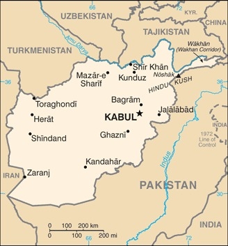
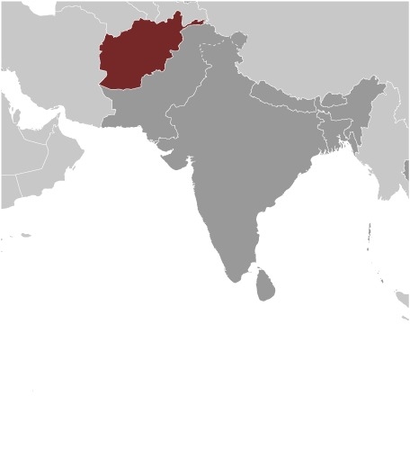
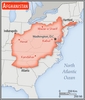
Southern Asia, north and west of Pakistan, east of Iran
Geographic coordinates
33 00 N, 65 00 E
Map references
Asia

Land boundaries
total: 5,987 km
border countries (6): China 91 km, Iran 921 km, Pakistan 2670 km, Tajikistan 1357 km, Turkmenistan 804 km, Uzbekistan 144 km
Coastline
0 km (landlocked)
Maritime claims
none (landlocked)
Climate
arid to semiarid; cold winters and hot summers
Terrain
mostly rugged mountains; plains in north and southwest
Elevation
highest point: Noshak 7,492 m
lowest point: Amu Darya 258 m
mean elevation: 1,884 m
Natural resources
natural gas, petroleum, coal, copper, chromite, talc, barites, sulfur, lead, zinc, iron ore, salt, precious and semiprecious stones, arable land
Land use
agricultural land: 58.1% (2018 est.)
arable land: 11.8% (2018)
permanent crops: 0.3% (2018)
permanent pasture: 46% (2018)
forest: 1.85% (2018 est.)
other: 40.1% (2018)
Irrigated land
32,080 sq km (2012)
Major watersheds (area sq km)
Indian Ocean drainage: Indus (1,081,718 sq km)
Internal (endorheic basin) drainage: Amu Darya (534,739 sq km); Tarim Basin (1,152,448 sq km)
Major lakes (area sq km)
Salt water lake(s): Ab-e Istadah-ye Muqur (endorheic basin) - 520 sq km
Major rivers (by length in km)
Amu Darya (shared with Tajikistan [s], Turkmenistan, and Uzbekistan [m]) - 2,620 km; Helmand river source (shared with Iran) - 1,130 km
note – [s] after country name indicates river source; [m] after country name indicates river mouth
Population distribution
populations tend to cluster in the foothills and periphery of the rugged Hindu Kush range; smaller groups are found in many of the country's interior valleys; in general, the east is more densely settled, while the south is sparsely populated
Natural hazards
damaging earthquakes occur in Hindu Kush mountains; flooding; droughts
Geography - note
landlocked; the Hindu Kush mountains that run northeast to southwest divide the northern provinces from the rest of the country; the highest peaks are in the northern Vakhan (Wakhan Corridor)
People and Society
Nationality
noun: Afghan(s)
adjective: Afghan
Ethnic groups
Current reliable statistical data on ethnicity in Afghanistan are not available; Afghanistan's 2004 Constitution cited Pashtun, Tajik, Hazara, Uzbek, Turkman, Baluch, Pachaie, Nuristani, Aymaq, Arab, Qirghiz, Qizilbash, Gujur, and Brahwui ethnicities; Afghanistan has dozens of other small ethnic groups
Languages
Afghan Persian or Dari (official, lingua franca) 77%, Pashto (official) 48%, Uzbeki 11%, English 6%, Turkmani 3%, Urdu 3%, Pachaie 1%, Nuristani 1%, Arabic 1%, Balochi 1%, other <1% (2020 est.)
major-language sample(s):
کتاب حقایق جهان، مرجعی ضروری برای اطلاعات اولیە (Dari)
د دنیا د حقائېقو کتاب، بنیادی معلوماتو لپاره ضروری سرچینه- (Pashto)The World Factbook, the indispensable source for basic information.
note 1: percentages sum toi more than 100% because many people are multilingual
note 2: Uzbeki, Turkmani, Pachaie, Nuristani, Balochi, and Pamiri are the third official languages in areas where the majority speaks themDari audio sample:Pashto audio sample:
Religions
Sunni 84.7 - 89.7%, Shia 10 - 15%, other <0.3% (2009 est.)
Age structure
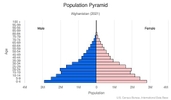
0-14 years: 40.62% (male 7,562,703/female 7,321,646)
15-24 years: 21.26% (male 3,960,044/female 3,828,670)
25-54 years: 31.44% (male 5,858,675/female 5,661,887)
55-64 years: 4.01% (male 724,597/female 744,910)
65 years and over: 2.68% (male 451,852/female 528,831) (2020 est.)

Dependency ratios
total dependency ratio: 88.8
youth dependency ratio: 75.3
elderly dependency ratio: 4.8
potential support ratio: 21 (2020 est.)
Median age
total: 19.5 years
male: 19.4 years
female: 19.5 years (2020 est.)
Population distribution
populations tend to cluster in the foothills and periphery of the rugged Hindu Kush range; smaller groups are found in many of the country's interior valleys; in general, the east is more densely settled, while the south is sparsely populated
Urbanization
urban population: 26.3% of total population (2021)
rate of urbanization: 3.34% annual rate of change (2020-25 est.)
Major urban areas - population
4.336 million KABUL (capital) (2021)
Sex ratio
at birth: 1.05 male(s)/female
0-14 years: 1.03 male(s)/female
15-24 years: 1.03 male(s)/female
25-54 years: 1.03 male(s)/female
55-64 years: 0.97 male(s)/female
65 years and over: 0.85 male(s)/female
total population: 1.03 male(s)/female (2020 est.)
Mother's mean age at first birth
19.9 years (2015 est.)
note: median age at first birth among women 25-49
Maternal mortality ratio
638 deaths/100,000 live births (2017 est.)
country comparison to the world: 11Infant mortality rate
total: 106.75 deaths/1,000 live births
male: 115.21 deaths/1,000 live births
female: 97.86 deaths/1,000 live births (2021 est.)
Life expectancy at birth
total population: 53.25 years
male: 51.73 years
female: 54.85 years (2021 est.)
Contraceptive prevalence rate
18.9% (2018)
note: percent of women aged 12-49
Drinking water source
improved: urban: 95.9% of population
rural: 61.4% of population
total: 70.2% of population
unimproved: urban: 3.2% of population
rural: 38.6% of population
total: 38.6% of population (2017 est.)
Current Health Expenditure
9.4% (2018)
Physicians density
0.28 physicians/1,000 population (2016)
Hospital bed density
0.4 beds/1,000 population (2017)
Sanitation facility access
improved: urban: 83.6% of population
rural: 43% of population
total: 53.2% of population
unimproved: urban: 16.4% of population
rural: 57% of population
total: 46.8% of population (2017 est.)
HIV/AIDS - adult prevalence rate
<.1% (2020 est.)
HIV/AIDS - deaths
<1,000 (2020 est.)
Major infectious diseases
degree of risk: intermediate (2020)
food or waterborne diseases: bacterial diarrhea, hepatitis A, and typhoid fever
vectorborne diseases: Crimea-Congo hemorrhagic fever, malaria
Literacy
definition: age 15 and over can read and write
total population: 37.3%
male: 52.1%
female: 22.6% (2021)
School life expectancy (primary to tertiary education)
total: 10 years
male: 13 years
female: 8 years (2018)
Unemployment, youth ages 15-24
total: 16.2%
male: 14.5%
female: 21.1% (2020)
Environment
Environment - current issues
limited natural freshwater resources; inadequate supplies of potable water; soil degradation; overgrazing; deforestation (much of the remaining forests are being cut down for fuel and building materials); desertification; air and water pollution in overcrowded urban areas
Environment - international agreements
party to: Biodiversity, Climate Change, Climate Change-Kyoto Protocol, Climate Change-Paris Agreement, Comprehensive Nuclear Test Ban, Desertification, Endangered Species, Environmental Modification, Hazardous Wastes, Marine Dumping-London Convention, Nuclear Test Ban, Ozone Layer Protection
signed, but not ratified: Law of the Sea, Marine Life Conservation
Air pollutants
particulate matter emissions: 53.17 micrograms per cubic meter (2016 est.)
carbon dioxide emissions: 8.67 megatons (2016 est.)
methane emissions: 90.98 megatons (2020 est.)
Climate
arid to semiarid; cold winters and hot summers
Land use
agricultural land: 58.1% (2018 est.)
arable land: 11.8% (2018)
permanent crops: 0.3% (2018)
permanent pasture: 46% (2018)
forest: 1.85% (2018 est.)
other: 40.1% (2018)
Urbanization
urban population: 26.3% of total population (2021)
rate of urbanization: 3.34% annual rate of change (2020-25 est.)
Revenue from forest resources
forest revenues: 0.2% of GDP (2018 est.)
country comparison to the world: 93Major infectious diseases
degree of risk: intermediate (2020)
food or waterborne diseases: bacterial diarrhea, hepatitis A, and typhoid fever
vectorborne diseases: Crimea-Congo hemorrhagic fever, malaria
Food insecurity
severe localized food insecurity: due to civil conflict, population displacement, and economic slowdown - the food security situation worsened in recent months due to the impact of COVID‑19 as informal labor opportunities and remittances declined; between November 2020 and March 2021, about 13.15 million people were estimated to be in severe acute food insecurity and to require urgent humanitarian assistance, including 8.52 million people in "Crisis" and 4.3 million people in "Emergency"; the food security of the vulnerable populations, including IDPs and the urban poor, is likely to deteriorate as curfews and restrictions on movements to contain the COVID‑19 outbreak limit the employment opportunities for casual laborers (2021)
Waste and recycling
municipal solid waste generated annually: 5,628,525 tons (2016 est.)
Major lakes (area sq km)
Salt water lake(s): Ab-e Istadah-ye Muqur (endorheic basin) - 520 sq km
Major rivers (by length in km)
Amu Darya (shared with Tajikistan [s], Turkmenistan, and Uzbekistan [m]) - 2,620 km; Helmand river source (shared with Iran) - 1,130 km
note – [s] after country name indicates river source; [m] after country name indicates river mouth
Major watersheds (area sq km)
Indian Ocean drainage: Indus (1,081,718 sq km)
Internal (endorheic basin) drainage: Amu Darya (534,739 sq km); Tarim Basin (1,152,448 sq km)
Total water withdrawal
municipal: 203.4 million cubic meters (2017 est.)
industrial: 169.5 million cubic meters (2017 est.)
agricultural: 20 billion cubic meters (2017 est.)
Total renewable water resources
65.33 billion cubic meters (2017 est.)
Government
Country name
conventional long form: Islamic Republic of Afghanistan
conventional short form: Afghanistan
local long form: Jamhuri-ye Islami-ye Afghanistan
local short form: Afghanistan
former: Republic of Afghanistan
etymology: the name "Afghan" originally referred to the Pashtun people (today it is understood to include all the country's ethnic groups), while the suffix "-stan" means "place of" or "country"; so Afghanistan literally means the "Land of the Afghans"
Government type
presidential Islamic republic
Capital
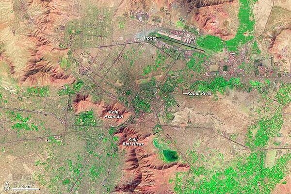
name: Kabul
geographic coordinates: 34 31 N, 69 11 E
time difference: UTC+4.5 (9.5 hours ahead of Washington, DC, during Standard Time)
daylight saving time: does not observe daylight savings time
etymology: named for the Kabul River, but the river's name is of unknown origin
Administrative divisions
34 provinces (welayat, singular - welayat); Badakhshan, Badghis, Baghlan, Balkh, Bamyan, Daykundi, Farah, Faryab, Ghazni, Ghor, Helmand, Herat, Jowzjan, Kabul, Kandahar, Kapisa, Khost, Kunar, Kunduz, Laghman, Logar, Nangarhar, Nimroz, Nuristan, Paktika, Paktiya, Panjshir, Parwan, Samangan, Sar-e Pul, Takhar, Uruzgan, Wardak, Zabul
Independence
19 August 1919 (from UK control over Afghan foreign affairs)
National holiday
Independence Day, 19 August (1919)
Constitution
history: several previous; latest drafted 14 December 2003 - 4 January 2004, signed 16 January 2004, ratified 26 January 2004
amendments: proposed by a commission formed by presidential decree followed by the convention of a Grand Council (Loya Jirga) decreed by the president; passage requires at least two-thirds majority vote of the Loya Jirga membership and endorsement by the president
Legal system
mixed legal system of civil, customary, and Islamic (sharia) law
International law organization participation
has not submitted an ICJ jurisdiction declaration; accepts ICCt jurisdiction
Citizenship
citizenship by birth: no
citizenship by descent only: at least one parent must have been born in - and continuously lived in - Afghanistan
dual citizenship recognized: no
residency requirement for naturalization: 5 years
Suffrage
18 years of age; universal
Executive branch
chief of state: president (vacant); President Ashraf GHANI departed the country on 15 August 2021; CEO Abdullah ABDULLAH, Dr. (since 29 September 2014); First Vice President Abdul Rashid DOSTAM (since 29 September 2014); Second Vice President Sarwar DANESH (since 29 September 2014); First Deputy CEO Khyal Mohammad KHAN; Second Deputy CEO Mohammad MOHAQQEQ; note - the president is both chief of state and head of government
head of government: president (vacant); President Ashraf GHANI departed the country on 15 August 2021; CEO Abdullah ABDULLAH, Dr. (since 29 September 2014); First Vice President Abdul Rashid DOSTAM (since 29 September 2014); Second Vice President Sarwar DANESH (since 29 September 2014); First Deputy CEO Khyal Mohammad KHAN; Second Deputy CEO Mohammad MOHAQQEQ
cabinet: Cabinet consists of 25 ministers appointed by the president, approved by the National Assembly
elections/appointments: president directly elected by absolute majority popular vote in 2 rounds if needed for a 5-year term (eligible for a second term); election last held on 28 September 2019
election results: Ashraf GHANI declared winner by the Independent Election Commission on 18 February 2020; Ashraf GHANI 50.6%, Abdullah ABDULLAH, Dr. 39.5%, other 0.9%
note: Ashraf GHANI left the country on 15 August 2021; on 7 September 2021, Mullah Mohammad HASSAN was announced as the head of an interim government
Legislative branch
description: bicameral National Assembly consists of:
Meshrano Jirga or House of Elders (102 seats; 34 members indirectly elected by absolute majority vote in 2 rounds if needed by district councils to serve 3-year terms, 34 indirectly elected by absolute majority vote in 2 rounds if needed by provincial councils to serve 4-year terms, and 34 appointed by the president from nominations by civic groups, political parties, and the public, of which 17 must be women, 2 must represent the disabled, and 2 must be Kuchi nomads; presidential appointees serve 5-year terms)
Wolesi Jirga or House of People (250 seats, including 68 reserved for women; members directly elected in multi-seat constituencies by proportional representation vote to serve 5-year terms)
elections: Meshrano Jirga - district councils - within 5 days of installation; provincial councils - within 15 days of installation; presidential appointees - within 2 weeks after the presidential inauguration (last held 10 January 2015); note - in early 2016, President Mohammad Ashraf Ghani extended their mandate until parliamentary and district elections are held.
Wolesi Jirga - last held on 20 October 2018) (next to be held in 2023)
election results:
Meshrano Jirga - percent of vote by party - NA; seats by party - NA; composition - men 85, women 17, percent of women 16.7%
Wolesi Jirga - percent of vote by party NA; seats by party - NA; composition - men 182, women 68, percent of women 27.2%; note - total National Assembly percent of women 24.1%
note: the constitution allows the government to convene a constitutional Loya Jirga (Grand Council) on issues of independence, national sovereignty, and territorial integrity; it consists of members of the National Assembly and chairpersons of the provincial and district councils; a Loya Jirga can amend provisions of the constitution and prosecute the president; no constitutional Loya Jirga has ever been held, and district councils have never been elected; the president appointed 34 members of the Meshrano Jirga that the district councils should have indirectly elected
Judicial branch
highest courts: Supreme Court or Stera Mahkama (consists of the supreme court chief and 8 justices organized into criminal, public security, civil, and commercial divisions or dewans)
judge selection and term of office: court chief and justices appointed by the president with the approval of the Wolesi Jirga; court chief and justices serve single 10-year terms
subordinate courts: Appeals Courts; Primary Courts; Special Courts for issues including narcotics, security, property, family, and juveniles
Political parties and leaders
note - the Ministry of Justice licensed 72 political parties as of April 2019
International organization participation
ADB, CICA, CP, ECO, EITI (candidate country), FAO, G-77, IAEA, IBRD, ICAO, ICC (NGOs), ICCt, ICRM, IDA, IDB, IFAD, IFC, IFRCS, ILO, IMF, Interpol, IOC, IOM, IPU, ISO (correspondent), ITSO, ITU, ITUC (NGOs), MIGA, NAM, OIC, OPCW, OSCE (partner), SAARC, SACEP, SCO (dialogue member), UN, UNAMA, UNCTAD, UNESCO, UNHCR, UNIDO, UNWTO, UPU, WCO, WFTU (NGOs), WHO, WIPO, WMO, WTO
Diplomatic representation in the US
chief of mission: Ambassador Adela RAZ (since July 2021)
chancery: 2341 Wyoming Avenue NW, Washington, DC 20008
telephone: [1] (202) 483-6410
FAX: [1] (202) 483-6488
email address and website:
info@afghanembassy.us
https://www.afghanembassy.us/
consulate(s) general: Los Angeles, New York, Washington, DC
Diplomatic representation from the US
chief of mission: Ambassador (vacant); Charge d'Affaires Ross WILSON (since 18 January 2020)
embassy: Bibi Mahru, Kabul
mailing address: 6180 Kabul Place, Washington DC 20521-6180
telephone: [00 93] (0) 700-10-8000
FAX: [00 93] (0) 700-108-564
email address and website:
KabulACS@state.gov
https://af.usembassy.gov/
Flag description
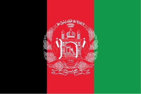
three equal vertical bands of black (hoist side), red, and green, with the national emblem in white centered on the red band and slightly overlapping the other 2 bands; the center of the emblem features a mosque with pulpit and flags on either side, below the mosque are Eastern Arabic numerals for the solar year 1298 (1919 in the Gregorian calendar, the year of Afghan independence from the UK); this central image is circled by a border consisting of sheaves of wheat on the left and right, in the upper-center is an Arabic inscription of the Shahada (Muslim creed) below which are rays of the rising sun over the Takbir (Arabic expression meaning "God is great"), and at bottom center is a scroll bearing the name Afghanistan; black signifies the past, red is for the blood shed for independence, and green can represent either hope for the future, agricultural prosperity, or Islam
note: Afghanistan had more changes to its national flag in the 20th century - 19 by one count - than any other country; the colors black, red, and green appeared on most of them
National symbol(s)
lion; national colors: red, green, black
National anthem
name: "Milli Surood" (National Anthem)
lyrics/music: Abdul Bari JAHANI/Babrak WASA
note: adopted 2006; the 2004 constitution of the post-Taliban government mandated that a new national anthem should be written containing the phrase "Allahu Akbar" (God is Greatest) and mentioning the names of Afghanistan's ethnic groups
Economy
Economic overview
Prior to 2001, Afghanistan was an extremely poor, landlocked, and foreign aid-dependent country. Increased domestic economic activity occurred following the US-led invasion, as well as significant international economic development assistance. This increased activity expanded access to water, electricity, sanitation, education, and health services, and fostered consistent growth in government revenues since 2014. While international security forces have been drawing down since 2012, with much higher U.S. forces’ drawdowns occurring since 2017, economic progress continues, albeit uneven across sectors and key economic indicators. After recovering from the 2018 drought and growing 3.9% in 2019, political instability, expiring international financial commitments, and the COVID-19 pandemic have wrought significant adversity on the Afghan economy, with a projected 5% contraction.
Current political parties’ power-sharing agreement following the September 2019 presidential elections as well as ongoing Taliban attacks and peace talks have led to Afghan economic instability. This instability, coupled with expiring international grant and assistance, endangers recent fiscal gains and has led to more internally displaced persons. In November 2020, Afghanistan secured $12 billion in additional international aid for 2021-2025, much of which is conditional upon Taliban peace progress. Additionally, Afghanistan continues to experience influxes of repatriating Afghanis, mostly from Iran, significantly straining economic and security institutions.
Afghanistan’s trade deficit remains at approximately 31% of GDP and is highly dependent on financing through grants and aid. While Afghan agricultural growth remains consistent, recent industrial and services growth have been enormously impacted by COVID-19 lockdowns and trade cessations. While trade with the People’s Republic of China has rapidly expanded in recent years, Afghanistan still relies heavily upon India and Pakistan as export partners but is more diverse in its import partners. Furthermore, Afghanistan still struggles to effectively enforce business contracts, facilitate easy tax collection, and enable greater international trade for domestic enterprises.
Current Afghan priorities focus on the following goals:
- Securing international economic agreements, many of which are contingent on Taliban peace progress;
- Increasing exports to $2 billion USD by 2023;
- Continuing to expand government revenue collection;
- Countering corruption and navigating challenges from the power-sharing agreement; and
- Developing a strong private sector that can empower the economy.
Real GDP (purchasing power parity)
$77.04 billion note: data are in 2017 dollars (2020 est.)
$78.56 billion note: data are in 2017 dollars (2019 est.)
$75.6 billion note: data are in 2017 dollars (2018 est.)
note: data are in 2017 dollars
Real GDP growth rate
2.7% (2017 est.)
2.2% (2016 est.)
1% (2015 est.)
Real GDP per capita
$2,000 note: data are in 2017 dollars (2020 est.)
$2,100 note: data are in 2017 dollars (2019 est.)
$2,000 note: data are in 2017 dollars (2018 est.)
note: data are in 2017 dollars
GDP (official exchange rate)
$20.24 billion (2017 est.)
GDP - composition, by sector of origin
agriculture: 23% (2016 est.)
industry: 21.1% (2016 est.)
services: 55.9% (2016 est.)
note: data exclude opium production
GDP - composition, by end use
household consumption: 81.6% (2016 est.)
government consumption: 12% (2016 est.)
investment in fixed capital: 17.2% (2016 est.)
investment in inventories: 30% (2016 est.)
exports of goods and services: 6.7% (2016 est.)
imports of goods and services: -47.6% (2016 est.)
Agricultural products
wheat, milk, grapes, vegetables, potatoes, watermelons, melons, rice, onions, apples
Industries
small-scale production of bricks, textiles, soap, furniture, shoes, fertilizer, apparel, food products, non-alcoholic beverages, mineral water, cement; handwoven carpets; natural gas, coal, copper
Labor force - by occupation
agriculture: 44.3%
industry: 18.1%
services: 37.6% (2017 est.)
Population below poverty line
54.5% (2016 est.)
Gini Index coefficient - distribution of family income
29.4 (2008)
country comparison to the world: 153Household income or consumption by percentage share
lowest 10%: 3.8%
highest 10%: 24% (2008)
Budget
revenues: 2.276 billion (2017 est.)
expenditures: 5.328 billion (2017 est.)
Fiscal year
21 December - 20 December
Current account balance
$1.014 billion (2017 est.)
$1.409 billion (2016 est.)
Exports
$1.48 billion note: data are in current year dollars (2020 est.)
$1.52 billion note: data are in current year dollars (2019 est.)
$1.61 billion note: data are in current year dollars (2018 est.)
note: not including illicit exports or reexports
Exports - partners
United Arab Emirates 45%, Pakistan 24%, India 22%, China 1% (2019)
Exports - commodities
gold, grapes, opium, fruits and nuts, insect resins, cotton, handwoven carpets, soapstone, scrap metal (2019)
Imports
$6.98 billion note: data are in current year dollars (2020 est.)
$7.37 billion note: data are in current year dollars (2019 est.)
$7.98 billion note: data are in current year dollars (2018 est.)
Imports - partners
United Arab Emirates 23%, Pakistan 17%, India 13%, China 9%, United States 9%, Uzbekistan 7%, Kazakhstan 6% (2019)
Imports - commodities
wheat flours, broadcasting equipment, refined petroleum, rolled tobacco, aircraft parts, synthetic fabrics (2019)
Reserves of foreign exchange and gold
$7.187 billion (31 December 2017 est.)
$6.901 billion (31 December 2015 est.)
Exchange rates
afghanis (AFA) per US dollar -
7.87 (2017 est.)
68.03 (2016 est.)
67.87 (2015)
61.14 (2014 est.)
57.25 (2013 est.)
Unemployment, youth ages 15-24
total: 16.2%
male: 14.5%
female: 21.1% (2020)
Energy
Electricity access
electrification - total population: 99% (2018)
electrification - urban areas: 100% (2018)
electrification - rural areas: 98% (2018)
Electricity - installed generating capacity
634,100 kW (2016 est.)
country comparison to the world: 138Electricity - from fossil fuels
45% of total installed capacity (2016 est.)
country comparison to the world: 159Electricity - from nuclear fuels
0% of total installed capacity (2017 est.)
country comparison to the world: 32Electricity - from hydroelectric plants
52% of total installed capacity (2017 est.)
country comparison to the world: 34Electricity - from other renewable sources
4% of total installed capacity (2017 est.)
country comparison to the world: 110Refined petroleum products - consumption
35,000 bbl/day (2016 est.)
country comparison to the world: 117Natural gas - proved reserves
49.55 billion cu m (1 January 2018 est.)
country comparison to the world: 62Communications
Telephones - fixed lines
total subscriptions: 134,636
subscriptions per 100 inhabitants: less than 1 (2019 est.)
Telephones - mobile cellular
total subscriptions: 22,580,071
subscriptions per 100 inhabitants: 63.18 (2019 est.)
Telecommunication systems
general assessment: before the Taliban takeover in August 2021, Afghanistan had successfully rebuilt infrastructure to create a functional telecom sector that covered nearly all of the population; due to mountainous geography, country relies on its mobile network; mobile broadband penetration growing, but is still low compared to other countries in Asia; operator launched LTE in Kabul; World Bank and other donors support development of a nationwide fiber backbone; terrestrial cable connectivity to five neighboring countries; work on the ‘Wakhan Corridor Fiber Optic Survey Project’ to connect to China is nearing completion; major importer of broadcasting equipment from UAE (2019)
domestic: before the Taliban takeover in August 2021, less than 1 per 100 for fixed-line teledensity; 59 per 100 for mobile-cellular; an increasing number of Afghans utilize mobile-cellular phone networks (2019)
international: country code - 93; multiple VSAT's provide international and domestic voice and data connectivity (2019)
Broadcast media
since the Taliban takeover in August 2021, independent media outlets have decreased in number and are probably self-censoring criticism of the Taliban; before August 2021, the former Afghan Government-owned broadcaster, Radio Television Afghanistan (RTA), operated a series of radio and television stations in Kabul and the provinces and the country had an estimated 174 private radio stations and 83 TV stations; television and radio are key media platforms; only about a fifth of Afghans use the internet, mostly through smartphones (2021)
Internet users
total: 8.64 million (2021 est.)
percent of population: 13.5% (2019 est.)
Broadband - fixed subscriptions
total: 19,683
subscriptions per 100 inhabitants: less than 1 (2018 est.)
Transportation
National air transport system
number of registered air carriers: 3 (2020)
inventory of registered aircraft operated by air carriers: 13
annual passenger traffic on registered air carriers: 1,722,612 (2018)
annual freight traffic on registered air carriers: 29.56 million mt-km (2018)
Airports - with paved runways
total: 29
over 3,047 m: 4
2,438 to 3,047 m: 8
1,524 to 2,437 m: 12
914 to 1,523 m: 2
under 914 m: 3 (2020)
Airports - with unpaved runways
total: 17
2,438 to 3,047 m: 1
1,524 to 2,437 m: 7
914 to 1,523 m: 4
under 914 m: 5 (2020)
Heliports
1 (2020)
Pipelines
466 km gas (2013)
Roadways
total: 34,903 km (2017)
paved: 17,903 km (2017)
unpaved: 17,000 km (2017)
Waterways
1,200 km (chiefly Amu Darya, which handles vessels up to 500 DWT) (2011)
country comparison to the world: 58Ports and terminals
river port(s): Kheyrabad, Shir Khan
Military and Security
Military and security forces
not available; as of late 2021, the Taliban had established a Ministry of Defense and named commanders and deputy commanders for 8 regional corps
prior to August 2021, the Afghan National Defense and Security Forces (ANDSF) were comprised of military, police, and other security elements under the Ministry of Defense and Ministry of Interior:
Ministry of Defense: Afghan National Army ((ANA), Afghan Air Force, Afghan Army Special Security Forces (ASSF; includes ANA Special Operations Command, General Command Police Special Units (GCPSU), and the Special Mission Wing (SMW)), Afghanistan National Army Territorial Forces (ANA-TF, lightly-armed local security forces); Afghan Border Force (ABF); Afghan National Civil Order Force (ANCOF)
Ministry of Interior: Afghan Uniform (National) Police (AUP); Public Security Police (PSP); Afghan Border Police (ABP); Afghan Anti-Crime Police; Afghan Local Police; Afghan Public Protection Force; Special Security Forces (2021)
Military expenditures
1.2% of GDP (2019)
1% of GDP (2018)
0.9% of GDP (2017)
1% of GDP (2016)
1% of GDP (2015)
Military and security service personnel strengths
not available; prior to August 2021, the ANDSF had approximately 300,000 personnel (180,000 Ministry of Defense; 120,000 Ministry of Interior) (2021)
Military equipment inventories and acquisitions
the former Afghan military's inventory was mostly a mix of Soviet-era and more modern US and Russian equipment (2021)
Military service age and obligation
not available
Military - note
during the fighting with the Afghan Government, the Taliban’s military operations and strategy were directed by a leadership council (Rahbari Shura) led by HAIBATULLAH Akhundzada; Taliban forces were a decentralized guerrilla and militia force of approximately 60-80,000 full-time fighters loosely organized as battalions and brigades with at least one corps headquarters; as of October 2021, the Taliban was still forming an official military structure, although it reportedly had named commanders for 8 regional corps and established a named special forces unit
Terrorism
Terrorist group(s)
Haqqani Taliban Network; Harakat ul-Mujahidin; Harakat ul-Jihad-i-Islami; Islamic Jihad Union; Islamic Movement of Uzbekistan; Islamic State of Iraq and ash-Sham-Khorasan Province; Islamic Revolutionary Guard Corps/Qods Force; Jaish-e-Mohammed; Jaysh al Adl (Jundallah); Lashkar i Jhangvi; Lashkar-e Tayyiba; al-Qa’ida; al-Qa'ida in the Indian Subcontinent; Tehrik-e-Taliban Pakistan
note: details about the history, aims, leadership, organization, areas of operation, tactics, targets, weapons, size, and sources of support of the group(s) appear(s) in Appendix T
Transnational Issues
Disputes - international
Afghan, Coalition, and Pakistan military meet periodically to clarify the alignment of the boundary on the ground and on maps and since 2014 have met to discuss collaboration on the Taliban insurgency and counterterrorism efforts; Afghan and Iranian commissioners have discussed boundary monument densification and resurvey; Iran protests Afghanistan's restricting flow of dammed Helmand River tributaries during drought; Pakistan has sent troops across and built fences along some remote tribal areas of its treaty-defined Durand Line border with Afghanistan which serve as bases for foreign terrorists and other illegal activities; Russia remains concerned about the smuggling of poppy derivatives from Afghanistan through Central Asian countries
Refugees and internally displaced persons
refugees (country of origin): 72,185 (Pakistan) (2020)
IDPs: 3.547 million (mostly Pashtuns and Kuchis displaced in the south and west due to natural disasters and political instability) (2020)
Trafficking in persons
current situation: human traffickers exploit domestic and foreign victims and returning Afghan migrants and exploit Afghan victims abroad; internal trafficking is more prevalent than transnational trafficking; traffickers exploit men, women, and a large number of children domestically; victims are subjected to forced labor in agriculture, brick kilns, carpet weaving, domestic servitude, commercial sex, begging, poppy cultivation and harvesting, salt mining, transnational drug smuggling, and truck driving; Afghan security forces and non-state armed groups, including the pro-government militias and the Taliban, continue to unlawfully recruit and use child soldiers; sexual exploitation of boys remains pervasive nationwide, and traffickers subject some boys to sexual exploitation abroad
tier rating:
Tier 3 — Afghanistan does not fully comply with the minimum standards for the elimination of trafficking in persons and is not making significant efforts to do so; the government decreased law enforcement efforts against civilian and official perpetrators of trafficking, and officials complicit in recruitment and use of child soldiers and the sexual exploitation of boys continued to operate with impunity; authorities continued to arrest, detain, and penalize many trafficking victims, including punishing sex trafficking victims for “moral crimes”; the judiciary remained underfunded, understaffed, and undertrained (2020)
Illicit drugs
the world’s largest producer of illicit opiates but it is not a major supplier to the United States; 215,000 hectares (ha) of opium poppy cultivated in Afghanistan in 2019; also produces methamphetamine and cannabis products; one of the highest domestic substance abuse rates in the world
(2018)