American Samoa


Introduction
Background
Tutuila was settled by 1000 B.C. and the island served as a refuge for exiled chiefs and defeated warriors from the other Samoan islands. The Manu’a Islands developed its own traditional chiefdom that maintained its autonomy by controlling oceanic trade. In 1722, Dutch explorer Jacob ROGGEVEEN was the first European to sail through the Manu’a Islands, and he was followed by French explorer Louis Antoine DE BOUGAINVILLE in 1768. Whalers and missionaries arrived in American Samoa in the 1830s, but American and European traders tended to favor the port in Apia - now in independent Samoa - over the smaller and less-developed Pago Pago on Tutuila. In the mid-1800s, a dispute arose in Samoa over control of the Samoan archipelago, with different chiefs gaining support from Germany, the UK, and the US. In 1872, the high chief of Tutuila offered the US exclusive rights to Pago Pago in return for US protection, but the US rejected this offer. As fighting resumed, the US agreed to the chief’s request in 1878 and set up a coaling station at Pago Pago. In 1899, with continued disputes over succession, Germany and the US agreed to divide the Samoan islands, while the UK withdrew its claims in exchange for parts of the Solomon Islands. Local chiefs on Tutuila formally ceded their land to the US in 1900, followed by the chief of Manu’a in 1904. The territory was officially named “American Samoa” in 1911.
The US administered the territory through the Department of the Navy, and in 1918, the naval governor instituted strict quarantine rules to prevent the spread of the Spanish flu, allowing American Samoa to avoid the deadly infection that ravaged the then-New Zealand administered territory of Samoa. In 1949, there was an attempt to organize the territory, granting it formal self-government, but local chiefs helped defeat the measure in the US Congress. Administration was transferred to the Department of the Interior in 1951, and in 1967, American Samoa adopted a constitution that provides significant protections for traditional Samoan land tenure rules, language, and culture. In 1977, after four attempts, voters approved a measure to directly elect their governor. Nevertheless, American Samoa officially remains an unorganized territory and people born in American Samoa are US nationals instead of US citizens, a status many American Samoans prefer.
Visit the Definitions and Notes page to view a description of each topic.
Geography
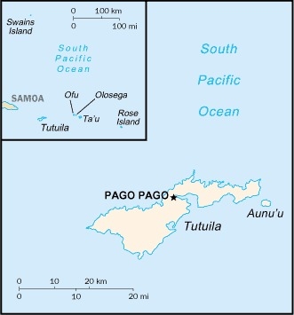
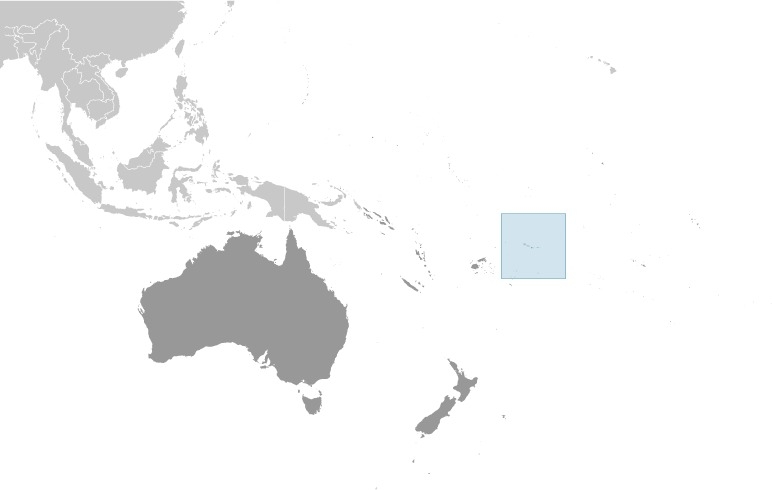
Location
Oceania, group of islands in the South Pacific Ocean, about halfway between Hawaii and New Zealand
Geographic coordinates
14 20 S, 170 00 W
Map references
Oceania
Area
total: 224 sq km
land: 224 sq km
water: 0 sq km
note: includes Rose Atoll and Swains Island
Area - comparative
slightly larger than Washington, DC
Land boundaries
total: 0 km
Coastline
116 km
Maritime claims
territorial sea: 12 nm
exclusive economic zone: 200 nm
Climate
tropical marine, moderated by southeast trade winds; annual rainfall averages about 3 m; rainy season (November to April), dry season (May to October); little seasonal temperature variation
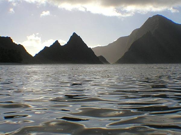
Terrain
five volcanic islands with rugged peaks and limited coastal plains, two coral atolls (Rose Atoll, Swains Island)
Elevation
highest point: Lata Mountain 964 m
lowest point: Pacific Ocean 0 m
Natural resources
pumice, pumicite
Land use
agricultural land: 24.5% (2018 est.)
arable land: 15% (2018 est.)
permanent crops: 9.5% (2018 est.)
permanent pasture: 0% (2018 est.)
forest: 75.5% (2018 est.)
other: 0% (2018 est.)
Irrigated land
0 sq km (2012)
Natural hazards
cyclones common from December to March
volcanism: limited volcanic activity on the Ofu and Olosega Islands; neither has erupted since the 19th century
Geography - note
Pago Pago has one of the best natural deepwater harbors in the South Pacific Ocean, sheltered by shape from rough seas and protected by peripheral mountains from high winds; strategic location in the South Pacific Ocean
People and Society
Nationality
noun: American Samoan(s) (US nationals)
adjective: American Samoan
Ethnic groups
Pacific Islander 92.6% (includes Samoan 88.9%, Tongan 2.9%, other .8%), Asian 3.6% (includes Filipino 2.2%, other 1.4%), mixed 2.7%, other 1.2% (2010 est.)
note: data represent population by ethnic origin or race
Languages
Samoan 88.6% (closely related to Hawaiian and other Polynesian languages), English 3.9%, Tongan 2.7%, other Pacific islander 3%, other 1.8% (2010 est.)
note: most people are bilingual
Religions
Christian 98.3%, other <1%, unaffiliated <1% (2020 est.)
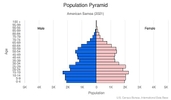
Age structure
0-14 years: 27.76% (male 7,063/female 6,662)
15-24 years: 18.16% (male 4,521/female 4,458)
25-54 years: 37.49% (male 9,164/female 9,370)
55-64 years: 9.69% (male 2,341/female 2,447)
65 years and over: 6.9% (male 1,580/female 1,831) (2020 est.)

Dependency ratios
total dependency ratio: NA
youth dependency ratio: NA
elderly dependency ratio: NA
potential support ratio: NA
Median age
total: 27.2 years
male: 26.7 years
female: 27.7 years (2020 est.)
Net migration rate
-32.18 migrant(s)/1,000 population (2021 est.)
country comparison to the world: 231Urbanization
urban population: 87.2% of total population (2021)
rate of urbanization: 0.26% annual rate of change (2020-25 est.)
Major urban areas - population
49,000 PAGO PAGO (capital) (2018)
Sex ratio
at birth: 1.06 male(s)/female
0-14 years: 1.06 male(s)/female
15-24 years: 1.01 male(s)/female
25-54 years: 0.98 male(s)/female
55-64 years: 0.96 male(s)/female
65 years and over: 0.86 male(s)/female
total population: 1 male(s)/female (2020 est.)
Infant mortality rate
total: 10.25 deaths/1,000 live births
male: 12.39 deaths/1,000 live births
female: 8 deaths/1,000 live births (2021 est.)
Life expectancy at birth
total population: 75.06 years
male: 72.55 years
female: 77.72 years (2021 est.)
Drinking water source
improved: urban: NA
rural: NA
total: 100% of population NA
unimproved: urban: NA
rural: NA
total: 0% of population NA (2017 est.)
Sanitation facility access
improved: total: 99% of population
unimproved: total: 1% of population (2017 est.)
Environment
Environment - current issues
limited supply of drinking water; pollution; waste disposal; coastal and stream alteration; soil erosion
Climate
tropical marine, moderated by southeast trade winds; annual rainfall averages about 3 m; rainy season (November to April), dry season (May to October); little seasonal temperature variation
Land use
agricultural land: 24.5% (2018 est.)
arable land: 15% (2018 est.)
permanent crops: 9.5% (2018 est.)
permanent pasture: 0% (2018 est.)
forest: 75.5% (2018 est.)
other: 0% (2018 est.)
Urbanization
urban population: 87.2% of total population (2021)
rate of urbanization: 0.26% annual rate of change (2020-25 est.)
Revenue from forest resources
forest revenues: 0% of GDP (2018 est.)
country comparison to the world: 159Waste and recycling
municipal solid waste generated annually: 18,989 tons (2016 est.)
Government
Country name
conventional long form: American Samoa
conventional short form: American Samoa
abbreviation: AS
etymology: the meaning of Samoa is disputed; some modern explanations are that the "sa" connotes "sacred" and "moa" indicates "center," so the name can mean "Holy Center"; alternatively, some assertions state that it can mean "place of the sacred moa bird" of Polynesian mythology; the name, however, may go back to Proto-Polynesian (PPn) times (before 1000 B.C.); a plausible PPn reconstruction has the first syllable as "sa'a" meaning "tribe or people" and "moa" meaning "deep sea or ocean" to convey the meaning "people of the deep sea"
Government type
unincorporated, unorganized Territory of the US with local self-government; republican form of territorial government with separate executive, legislative, and judicial branches;
Dependency status
unincorporated, unorganized Territory of the US; administered by the Office of Insular Affairs, US Department of the Interior
Capital
name: Pago Pago
geographic coordinates: 14 16 S, 170 42 W
time difference: UTC-11 (6 hours behind Washington, DC, during Standard Time)
note: pronounced pahn-go pahn-go
Administrative divisions
none (territory of the US); there are no first-order administrative divisions as defined by the US Government, but there are 3 districts and 2 islands* at the second order; Eastern, Manu'a, Rose Island*, Swains Island*, Western
Independence
none (territory of the US)
National holiday
Flag Day, 17 April (1900)
Constitution
history: adopted 17 October 1960; revised 1 July 1967
amendments: proposed by either house of the Legislative Assembly; passage requires three-fifths majority vote by the membership of each house, approval in a referendum, approval by the US Secretary of the Interior, and only by an act of the US Congress; amended several times, last in 2021
Legal system
mixed legal system of US common law and customary law
Citizenship
see United States
Note: in accordance with US Code Title 8, Section 1408, persons born in American Samoa are US nationals but not US citizens
Suffrage
18 years of age; universal
Executive branch
chief of state: President Joseph R. BIDEN Jr. (since 20 January 2021); Vice President Kamala D. HARRIS (since 20 January 2021)
head of government: Governor Lemanu Peleti MAUGA (since 3 January 2021)
cabinet: Cabinet consists of 12 department directors appointed by the governor with the consent of the Legislature or Fono
elections/appointments: president and vice president indirectly elected on the same ballot by an Electoral College of 'electors' chosen from each state to serve a 4-year term (eligible for a second term); under the US Constitution, residents of unincorporated territories, such as American Samoa, do not vote in elections for US president and vice president; however, they may vote in Democratic and Republican presidential primary elections; governor and lieutenant governor directly elected on the same ballot by absolute majority popular vote in 2 rounds if needed for a 4-year term (eligible for a second term); election last held on 3 November 2020 (next to be held in November 2024)
election results: Lemanu Peleti MAUGA elected governor in first round; percent of vote - Lemanu Peleti MAUGA (independent) 60.3%, Gaoteote Palaie TOFAU (independent) 21.9%, I'aulualo Fa'afetai TALIA (independent) 12.3%
Legislative branch
description: bicameral Legislature or Fono consists of:
Senate (18 seats; members indirectly selected by regional governing councils to serve 4-year terms)
House of Representatives (21 seats; 20 members directly elected by simple majority vote and 1 decided by public meeting on Swains Island; members serve 2-year terms)
elections:
Senate - last held on 3 November 2020 (next to be held in November 2024)
House of Representatives - last held on 3 November 2020 (next to be held in November 2024)
election results:
Senate - percent of vote by party - NA; seats by party - independent 18; composition - men 17, women 1; percent of women 5.6%
House of Representatives - percent of vote by party - NA; seats by party - NA; composition - NA
note: American Samoa elects 1 member by simple majority vote to serve a 2-year term as a delegate to the US House of Representatives; the delegate can vote when serving on a committee and when the House meets as the Committee of the Whole House, but not when legislation is submitted for a “full floor” House vote; election of delegate last held on 3 November 2020 (next to be held in November 2022); Amata Coleman RADEWAGEN elected delegate; Amata Coleman RADEWAGEN (Republican Party) 83.5%, Oreta CHRICHTON (Democratic Party) 14.4%, Meleagi SUITONU-CHAPMAN (Democratic Party) 2.1%
Judicial branch
highest courts: High Court of American Samoa (consists of the chief justice, associate chief justice, and 6 Samoan associate judges and organized into trial, family, drug, and appellate divisions); note - American Samoa has no US federal courts
judge selection and term of office: chief justice and associate chief justice appointed by the US Secretary of the Interior to serve for life; Samoan associate judges appointed by the governor to serve for life
subordinate courts: district and village courts
Political parties and leaders
Democratic Party [Fagafaga Daniel LANGKILDE, chairman]
Republican Party [William SWORD, chairman]
International organization participation
AOSIS (observer), Interpol (subbureau), IOC, PIF (observer), SPC
Diplomatic representation in the US
none (territory of the US)
Diplomatic representation from the US
embassy: none (territory of the US)
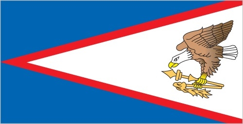
Flag description
blue, with a white triangle edged in red that is based on the fly side and extends to the hoist side; a brown and white American bald eagle flying toward the hoist side is carrying 2 traditional Samoan symbols of authority, a war club known as a "fa'alaufa'i" (upper; left talon), and a coconut-fiber fly whisk known as a "fue" (lower; right talon); the combination of symbols broadly mimics that seen on the US Great Seal and reflects the relationship between the US and American Samoa
National symbol(s)
a fue (coconut fiber fly whisk; representing wisdom) crossed with a to'oto'o (staff; representing authority); national colors: red, white, blue
National anthem
name: "Amerika Samoa" (American Samoa)
lyrics/music: Mariota Tiumalu TUIASOSOPO/Napoleon Andrew TUITELELEAPAGA
note: local anthem adopted 1950; as a territory of the United States, "The Star-Spangled Banner" is official (see United States)
Economy
Economic overview
American Samoa s a traditional Polynesian economy in which more than 90% of the land is communally owned. Economic activity is strongly linked to the US with which American Samoa conducts most of its commerce. Tuna fishing and processing are the backbone of the private sector with processed fish products as the primary exports. The fish processing business accounted for 15.5% of employment in 2015.
In late September 2009, an earthquake and the resulting tsunami devastated American Samoa and nearby Samoa, disrupting transportation and power generation, and resulting in about 200 deaths. The US Federal Emergency Management Agency oversaw a relief program of nearly $25 million. Transfers from the US Government add substantially to American Samoa's economic well-being.
Attempts by the government to develop a larger and broader economy are restrained by Samoa's remote location, its limited transportation, and its devastating hurricanes. Tourism has some potential as a source of income and jobs.
Real GDP (purchasing power parity)
$658 million (2016 est.)
$674.9 million (2015 est.)
$666.9 billion (2014 est.)
note: data are in 2016 US dollars
Real GDP growth rate
-2.5% (2016 est.)
1.2% (2015 est.)
1% (2014 est.)
Real GDP per capita
$11,200 (2016 est.)
$11,300 (2015 est.)
$11,200 (2014 est.)
GDP (official exchange rate)
$658 million (2016 est.)
Inflation rate (consumer prices)
-0.5% (2015 est.)
1.4% (2014 est.)
GDP - composition, by sector of origin
agriculture: 27.4% (2012)
industry: 12.4% (2012)
services: 60.2% (2012)
GDP - composition, by end use
household consumption: 66.4% (2016 est.)
government consumption: 49.7% (2016 est.)
investment in fixed capital: 7.3% (2016 est.)
investment in inventories: 5.1% (2016 est.)
exports of goods and services: 65% (2016 est.)
imports of goods and services: -93.5% (2016 est.)
Agricultural products
bananas, coconuts, vegetables, taro, breadfruit, yams, copra, pineapples, papayas; dairy products, livestock
Industries
tuna canneries (largely supplied by foreign fishing vessels), handicrafts
Labor force - by occupation
agriculture: NA
industry: 15.5%
services: 46.4% (2015 est.)
Household income or consumption by percentage share
lowest 10%: NA
highest 10%: NA
Budget
revenues: 249 million (2016 est.)
expenditures: 262.5 million (2016 est.)
Fiscal year
1 October - 30 September
Exports - partners
Australia 25%, Ghana 19%, Indonesia 15.6%, Burma 10.4%, Portugal 5.1% (2017)
Exports - commodities
canned tuna
Imports - partners
Fiji 10.7%, Singapore 10.4%, NZ 10.4%, South Korea 9.3%, Samoa 8.2%, Kenya 6.4%, Australia 5.2% (2017)
Imports - commodities
raw materials for canneries, food, petroleum products, machinery and parts
Exchange rates
the US dollar is used
Energy
Electricity - installed generating capacity
43,000 kW (2016 est.)
country comparison to the world: 194Electricity - from fossil fuels
98% of total installed capacity (2016 est.)
country comparison to the world: 27Electricity - from nuclear fuels
0% of total installed capacity (2017 est.)
country comparison to the world: 35Electricity - from hydroelectric plants
0% of total installed capacity (2017 est.)
country comparison to the world: 152Electricity - from other renewable sources
2% of total installed capacity (2017 est.)
country comparison to the world: 130Refined petroleum products - consumption
2,375 bbl/day (2016 est.)
country comparison to the world: 192Communications
Telephones - fixed lines
total subscriptions: 8,984
subscriptions per 100 inhabitants: 17.92 (2018 est.)
Telecommunication systems
general assessment: good telex, telegraph, facsimile, and cellular telephone services; one of the most complete and modern telecommunications systems in the South Pacific Islands; all inhabited islands have telephone connectivity
domestic: 18 per 100 fixed-line teledensity, domestic satellite system with 1 Comsat earth station (2018)
international: country code - 1-684; landing points for the ASH, Southern Cross NEXT and Hawaiki providing connectivity to New Zealand, Australia, American Samoa, Hawaii, California, and SAS connecting American Samoa with Samoa; satellite earth station - 1 (Intelsat-Pacific Ocean) (2019)
note: the COVID-19 pandemic continues to have a significant impact on production and supply chains globally; since 2020, some aspects of the telecom sector have experienced downturn, particularly in mobile device production; many network operators delayed upgrades to infrastructure; progress towards 5G implementation was postponed or slowed in some countries; consumer spending on telecom services and devices was affected by large-scale job losses and the consequent restriction on disposable incomes; the crucial nature of telecom services as a tool for work and school from home became evident, and received some support from governments
Broadcast media
3 TV stations; multi-channel pay TV services are available; about a dozen radio stations, some of which are repeater stations
Internet users
total: 22,200 (2021 est.)
percent of population: 31.3% (July 2016 est.)
Transportation
Airports - with paved runways
total: 3
over 3,047 m: 1
914 to 1,523 m: 1
under 914 m: 1 (2019)
Ports and terminals
major seaport(s): Pago Pago
Military and Security
Military - note
defense is the responsibility of the US
Transnational Issues
Disputes - international
Tokelau included American Samoa's Swains Island (Olosega) in its 2006 draft independence constitution