


Introduction
Background
Burma, colonized by Britain in the 19th century and granted independence post-World War II, contains scores of ethnic Burman and ethnic minority groups that have resisted external efforts to consolidate control of the country throughout its history, extending to the several minority groups today that possess independent fighting forces and control pockets of territory. Burman and armed ethnic minorities fought off-and-on until military Gen. NE WIN seized power in 1962. He ruled Burma until 1988 when a military junta took control. In 1990, the junta permitted an election but then rejected the results when the main opposition National League for Democracy (NLD) and its leader AUNG SAN SUU KYI won in a landslide. The junta placed AUNG SAN SUU KYI under house arrest for much of the next 20 years, until November 2010. In 2007, rising fuel prices in Burma led prodemocracy activists and Buddhist monks to launch a "Saffron Revolution" consisting of large protests against the ruling junta, which violently suppressed the movement by killing an unknown number of participants and arresting thousands. The regime prevented new elections until it had drafted a constitution designed to preserve its control; it passed the new constitution in its 2008 referendum, days after Cyclone Nargis killed at least 138,000. The junta conducted an election in 2010, but the NLD boycotted the vote, and the military’s Union Solidarity and Development Party easily won; international observers denounced the election as flawed.
With former or current military officers installed in its most senior positions, Burma began a halting process of political and economic reforms. Officials freed prisoners, brokered minority group cease fires, amended courts, expanded liberties, brought AUNG SAN SUU KYI into government in 2012, and permitted the NLD in 2015 to sweep into power. However, Burma’s first credibly elected civilian government, with AUNG SAN SUU KYI as the de facto head of state, faced strong headwinds after five decades of military dictatorship. The NLD government drew international criticism for blocking investigations of Burma’s military for operations, which the US Department of State determined constituted ethnic cleansing, on its Rohingya population that killed thousands and forced more than 740,000 Rohingya to flee into neighboring Bangladesh. The military did not support an NLD pledge in 2019 to examine reforming the military’s 2008 constitution. When the 2020 elections resulted in further NLD gains, the military denounced them as fraudulent. This challenge led Commander-in-Chief Sr. General MIN AUNG HLAING to launch a coup in February 2021 that has left Burma reeling with the return to authoritarian rule, the detention of AUNG SAN SUU KYI, and a renewal of the brutal repression of protestors, widespread violence, and economic decline.
Visit the Definitions and Notes page to view a description of each topic.
Geography
Location
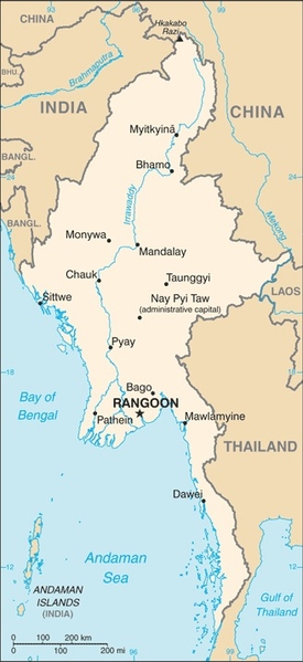
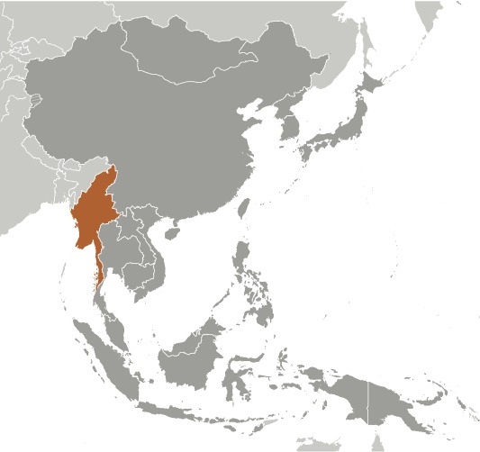
Southeastern Asia, bordering the Andaman Sea and the Bay of Bengal, between Bangladesh and Thailand
Geographic coordinates
22 00 N, 98 00 E
Map references
Southeast Asia

Land boundaries
total: 6,522 km
border countries (5): Bangladesh 271 km, China 2129 km, India 1468 km, Laos 238 km, Thailand 2416 km
Coastline
1,930 km
Maritime claims
territorial sea: 12 nm
contiguous zone: 24 nm
exclusive economic zone: 200 nm
continental shelf: 200 nm or to the edge of the continental margin
Climate
tropical monsoon; cloudy, rainy, hot, humid summers (southwest monsoon, June to September); less cloudy, scant rainfall, mild temperatures, lower humidity during winter (northeast monsoon, December to April)
Terrain
central lowlands ringed by steep, rugged highlands
Elevation
highest point: Gamlang Razi 5,870 m
lowest point: Andaman Sea/Bay of Bengal 0 m
mean elevation: 702 m
Natural resources
petroleum, timber, tin, antimony, zinc, copper, tungsten, lead, coal, marble, limestone, precious stones, natural gas, hydropower, arable land
Land use
agricultural land: 19.2% (2018 est.)
arable land: 16.5% (2018 est.)
permanent crops: 2.2% (2018 est.)
permanent pasture: 0.5% (2018 est.)
forest: 48.2% (2018 est.)
other: 32.6% (2018 est.)
Irrigated land
22,950 sq km (2012)
Major watersheds (area sq km)
Indian Ocean drainage: Brahmaputra (651,335 sq km), Ganges (1,016,124 sq km), Irrawaddy (413,710 sq km), Salween (271,914 sq km)
Pacific Ocean drainage: Mekong (805,604 sq km)
Major rivers (by length in km)
Mekong (shared with China [s], Laos, Thailand, Cambodia, and Vietnam [m]) - 4,350 km; Salween river mouth (shared with China [s] and Thailand) - 3,060 km; Irrawaddy river mouth (shared with China [s]) - 2,809 km; Chindwin - 1,158 km
note – [s] after country name indicates river source; [m] after country name indicates river mouth
Population distribution
population concentrated along coastal areas and in general proximity to the shores of the Irrawaddy River; the extreme north is relatively underpopulated
Natural hazards
destructive earthquakes and cyclones; flooding and landslides common during rainy season (June to September); periodic droughts
Geography - note
strategic location near major Indian Ocean shipping lanes; the north-south flowing Irrawaddy River is the country's largest and most important commercial waterway
People and Society
Nationality
noun: Burmese (singular and plural)
adjective: Burmese
Ethnic groups
Burman (Bamar) 68%, Shan 9%, Karen 7%, Rakhine 4%, Chinese 3%, Indian 2%, Mon 2%, other 5%
note: government recognizes 135 indigenous ethnic groups
Languages
Burmese (official)
major-language sample(s):
ကမ္ဘာ့အချက်အလက်စာအုပ်- အခြေခံအချက်အလက်တွေအတွက် မရှိမဖြစ်တဲ့ အရင်းအမြစ် (Burmese)
The World Factbook, the indispensable source for basic information.
note: minority ethnic groups use their own languages
Religions
Buddhist 87.9%, Christian 6.2%, Muslim 4.3%, Animist 0.8%, Hindu 0.5%, other 0.2%, none 0.1% (2014 est.)
note: religion estimate is based on the 2014 national census, including an estimate for the non-enumerated population of Rakhine State, which is assumed to mainly affiliate with the Islamic faith; as of December 2019, Muslims probably make up less than 3% of Burma's total population due to the large outmigration of the Rohingya population since 2017
Demographic profile
Burma’s 2014 national census – the first in more than 30 years – revealed that the country’s total population is approximately 51.5 million, significantly lower than the Burmese Government’s prior estimate of 61 million. The Burmese Government assumed that the 2% population growth rate between 1973 and 1983 remained constant and that emigration was zero, ignoring later sample surveys showing declining fertility rates and substantial labor migration abroad in recent decades. These factors reduced the estimated average annual growth rate between 2003 and 2014 to about .9%. Among Southeast Asian countries, Burma’s life expectancy is among the lowest and its infant and maternal mortality rates are among the highest. The large difference in life expectancy between women and men has resulted in older age cohorts consisting of far more women than men.
Burma’s demographic transition began in the 1950s, when mortality rates began to drop. Fertility did not start to decrease until the 1960s, sustaining high population growth until the decline accelerated in the 1980s. The birth rate has held fairly steady from 2000 until today. Since the 1970s, the total fertility rate (TFR) has fallen more than 60%, from almost 6 children per woman to 2.2 in 2016. The reduced TFR is largely a result of women marrying later and more women never marrying, both being associated with greater educational attainment and labor force participation among women. TFR, however, varies regionally, between urban and rural areas, by educational attainment, and among ethnic groups, with fertility lowest in urban areas (where it is below replacement level).
The shift in Burma’s age structure has been slow (45% of the population is still under 25 years of age) and uneven among its socioeconomic groups. Any economic boost from the growth of the working-age population is likely to take longer to develop, to have a smaller impact, and to be distributed unequally. Rural poverty and unemployment continue to drive high levels of internal and international migration. The majority of labor migration is internal, mainly from rural to urban areas. The new government’s growing regional integration, reforms, and improved diplomatic relations are increasing the pace of international migration and destination choices. As many as 4-5 million Burmese, mostly from rural areas and several ethnic groups, have taken up unskilled jobs abroad in agriculture, fishing, manufacturing, and domestic service. Thailand is the most common destination, hosting about 70% of Burma’s international migrants, followed by Malaysia, China, and Singapore.
Burma is a patchwork of more than 130 religious and ethnic groups, distinguishing it as one of the most diverse countries in the region. Ethnic minorities face substantial discrimination, and the Rohingya, the largest Muslim group, are arguably the most persecuted population in the country. The Burmese Government and the Buddhist majority see the Rohingya as a threat to identity, competitors for jobs and resources, terrorists, and some still resent them for their alliance with Burma’s British colonizers during its 19th century. Since at least the 1960s, they have been subjected to systematic human rights abuses, violence, marginalization, and disenfranchisement, which authorities continue to deny. Despite living in Burma for centuries, many Burmese see the Rohingya as illegal Bengali immigrants and refer to them Bengalis. As a result, the Rohingya have been classified as foreign residents and stripped of their citizenship, rendering them one of the largest stateless populations in the world.
Hundreds of thousands of Burmese from various ethnic groups have been internally displaced (an estimated 644,000 as of year-end 2016) or have fled to neighboring countries over the decades because of persecution, armed conflict, rural development projects, drought, and natural disasters. Bangladesh has absorbed the most refugees from Burma, with an estimated 33,000 officially recognized and 200,000 to 500,000 unrecognized Rohingya refugees, as of 2016. An escalation in violation has caused a surge in the inflow of Rohingya refugees since late August 2017, raising the number to an estimated 870,000. As of June 2017, another approximately 132,500 refugees, largely Rohingya and Chin, were living in Malaysia, and more than 100,000, mostly Karen, were housed in camps along the Burma-Thailand border.
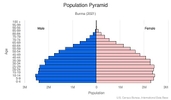
Age structure
0-14 years: 25.97% (male 7,524,869/female 7,173,333)
15-24 years: 17% (male 4,852,122/female 4,769,412)
25-54 years: 42.76% (male 11,861,971/female 12,337,482)
55-64 years: 8.22% (male 2,179,616/female 2,472,681)
65 years and over: 6.04% (male 1,489,807/female 1,928,778) (2020 est.)

Dependency ratios
total dependency ratio: 46.5
youth dependency ratio: 37.3
elderly dependency ratio: 9.1
potential support ratio: 10.9 (2020 est.)
Median age
total: 29.2 years
male: 28.3 years
female: 30 years (2020 est.)
Population distribution
population concentrated along coastal areas and in general proximity to the shores of the Irrawaddy River; the extreme north is relatively underpopulated
Urbanization
urban population: 31.4% of total population (2021)
rate of urbanization: 1.85% annual rate of change (2020-25 est.)
Major urban areas - population
5.422 million RANGOON (Yangon) (capital), 1.469 million Mandalay (2021)
Sex ratio
at birth: 1.06 male(s)/female
0-14 years: 1.05 male(s)/female
15-24 years: 1.02 male(s)/female
25-54 years: 0.96 male(s)/female
55-64 years: 0.88 male(s)/female
65 years and over: 0.77 male(s)/female
total population: 0.97 male(s)/female (2020 est.)
Mother's mean age at first birth
24.7 years (2015/16 est.)
note: median age at first birth among women 25-49
Maternal mortality ratio
250 deaths/100,000 live births (2017 est.)
country comparison to the world: 42Infant mortality rate
total: 33.71 deaths/1,000 live births
male: 37.04 deaths/1,000 live births
female: 30.17 deaths/1,000 live births (2021 est.)
Life expectancy at birth
total population: 69.62 years
male: 67.96 years
female: 71.39 years (2021 est.)
Contraceptive prevalence rate
52.2% (2015/16)
Drinking water source
improved: urban: 93% of population
rural: 76.9% of population
total: 81.8% of population
unimproved: urban: 7% of population
rural: 23.1% of population
total: 18.2% of population (2017 est.)
Current Health Expenditure
4.8% (2018)
Physicians density
0.68 physicians/1,000 population (2018)
Hospital bed density
1 beds/1,000 population (2017)
Sanitation facility access
improved: urban: 87.6% of population
rural: 67.6% of population
total: 73.7% of population
unimproved: urban: 12.4% of population
rural: 32.4% of population
total: 26.3% of population (2017 est.)
Major infectious diseases
degree of risk: very high (2020)
food or waterborne diseases: bacterial and protozoal diarrhea, hepatitis A, and typhoid fever
vectorborne diseases: dengue fever, malaria, and Japanese encephalitis
animal contact diseases: rabies
Literacy
definition: age 15 and over can read and write
total population: 89.1%
male: 92.4%
female: 86.3% (2019)
School life expectancy (primary to tertiary education)
total: 11 years
male: 10 years
female: 11 years (2018)
Unemployment, youth ages 15-24
total: 1.5%
male: 1.4%
female: 1.6% (2019 est.)
Environment
Environment - current issues
deforestation; industrial pollution of air, soil, and water; inadequate sanitation and water treatment contribute to disease; rapid depletion of the country's natural resources
Environment - international agreements
party to: Biodiversity, Climate Change, Climate Change-Kyoto Protocol, Climate Change-Paris Agreement, Comprehensive Nuclear Test Ban, Desertification, Endangered Species, Hazardous Wastes, Law of the Sea, Nuclear Test Ban, Ozone Layer Protection, Ship Pollution, Tropical Timber 2006, Wetlands
signed, but not ratified: none of the selected agreements
Air pollutants
particulate matter emissions: 34.69 micrograms per cubic meter (2016 est.)
carbon dioxide emissions: 25.28 megatons (2016 est.)
methane emissions: 42.2 megatons (2020 est.)
Climate
tropical monsoon; cloudy, rainy, hot, humid summers (southwest monsoon, June to September); less cloudy, scant rainfall, mild temperatures, lower humidity during winter (northeast monsoon, December to April)
Land use
agricultural land: 19.2% (2018 est.)
arable land: 16.5% (2018 est.)
permanent crops: 2.2% (2018 est.)
permanent pasture: 0.5% (2018 est.)
forest: 48.2% (2018 est.)
other: 32.6% (2018 est.)
Urbanization
urban population: 31.4% of total population (2021)
rate of urbanization: 1.85% annual rate of change (2020-25 est.)
Revenue from forest resources
forest revenues: 1.69% of GDP (2018 est.)
country comparison to the world: 38Major infectious diseases
degree of risk: very high (2020)
food or waterborne diseases: bacterial and protozoal diarrhea, hepatitis A, and typhoid fever
vectorborne diseases: dengue fever, malaria, and Japanese encephalitis
animal contact diseases: rabies
Food insecurity
severe localized food insecurity: due to conflict, political instability, and economic constraints - the political crisis, following the military takeover on 1 February 2021, resulted in increased tensions and unrest throughout the country; the current uncertain political situation may further compromise the fragile situation of vulnerable households and the Rohingya IDPs residing in the country; persisting conflicts in Rakhine, Chin, Kachin, Kayin, and Shan states have triggered large-scale population displacements particularly since 2017; income losses and a decline in remittances, due to the impact of the COVID‑19 pandemic, have affected the food security situation of vulnerable households (2021)
Waste and recycling
municipal solid waste generated annually: 4,677,307 tons (2000 est.)
Major rivers (by length in km)
Mekong (shared with China [s], Laos, Thailand, Cambodia, and Vietnam [m]) - 4,350 km; Salween river mouth (shared with China [s] and Thailand) - 3,060 km; Irrawaddy river mouth (shared with China [s]) - 2,809 km; Chindwin - 1,158 km
note – [s] after country name indicates river source; [m] after country name indicates river mouth
Major watersheds (area sq km)
Indian Ocean drainage: Brahmaputra (651,335 sq km), Ganges (1,016,124 sq km), Irrawaddy (413,710 sq km), Salween (271,914 sq km)
Pacific Ocean drainage: Mekong (805,604 sq km)
Total water withdrawal
municipal: 3.323 billion cubic meters (2017 est.)
industrial: 498.4 million cubic meters (2017 est.)
agricultural: 29.57 billion cubic meters (2017 est.)
Total renewable water resources
1,167,800,000,000 cubic meters (2017 est.)
Government
Country name
conventional long form: Union of Burma
conventional short form: Burma
local long form: Pyidaungzu Thammada Myanma Naingngandaw (translated as the Republic of the Union of Myanmar)
local short form: Myanma Naingngandaw
former: Socialist Republic of the Union of Burma, Union of Myanmar
etymology: both "Burma" and "Myanmar" derive from the name of the majority Burman (Bamar) ethnic group
note: since 1989 the military authorities in Burma and the deposed parliamentary government have promoted the name Myanmar as a conventional name for their state; the US Government has not officially adopted the name
Government type
parliamentary republic
Capital
name: Rangoon (Yangon); note - Nay Pyi Taw is the administrative capital
geographic coordinates: 16 48 N, 96 09 E
time difference: UTC+6.5 (11.5 hours ahead of Washington, DC, during Standard Time)
etymology: Rangoon (Yangon) is a compound of "yan" signifying "enemies" and "koun" meaning "to run out of" and so denoting "End of Strife"; Nay Pyi Taw translates as: "Great City of the Sun" or "Abode of Kings"
Administrative divisions
7 regions (taing-myar, singular - taing), 7 states (pyi ne-myar, singular - pyi ne), 1 union territory
regions: Ayeyarwady (Irrawaddy), Bago, Magway, Mandalay, Sagaing, Tanintharyi, Yangon (Rangoon)
states: Chin, Kachin, Kayah, Kayin, Mon, Rakhine, Shan
union territory: Nay Pyi Taw
Independence
4 January 1948 (from the UK)
National holiday
Independence Day, 4 January (1948); Union Day, 12 February (1947)
Constitution
history: previous 1947, 1974 (suspended until 2008); latest drafted 9 April 2008, approved by referendum 29 May 2008
amendments: proposals require at least 20% approval by the Assembly of the Union membership; passage of amendments to sections of the constitution on basic principles, government structure, branches of government, state emergencies, and amendment procedures requires 75% approval by the Assembly and approval in a referendum by absolute majority of registered voters; passage of amendments to other sections requires only 75% Assembly approval; amended 2015
Legal system
mixed legal system of English common law (as introduced in codifications designed for colonial India) and customary law
International law organization participation
has not submitted an ICJ jurisdiction declaration; non-party state to the ICCt
Citizenship
citizenship by birth: no
citizenship by descent only: both parents must be citizens of Burma
dual citizenship recognized: no
residency requirement for naturalization: none
note: an applicant for naturalization must be the child or spouse of a citizen
Suffrage
18 years of age; universal
Executive branch
chief of state: Prime Minister, SAC Chair, Sr. Gen. MIN AUNG HLAING (since 1 August 2021); note - MIN AUNG HLAING self-appointed himself to the role of prime minister of a “caretaker” provisional government that subsumed the State Administration Council (SAC) on 1 August 2021; the SAC, chaired by MIN AUNG HLAING, served as the executive governing body since 2 February 2021, following the 1 February 2021 military takeover of the government and the declaration of a state of emergency and still exists under the provisional government according to state media; MIN AUNG HLAING pledged to hold elections in 2023
head of government: Prime Minister, SAC Chair, Sr. Gen. MIN AUNG HLAING (since 1 August 2021); note - MIN AUNG HLAING self-appointed himself to the role of prime minister of a “caretaker” provisional government that subsumed the State Administration Council (SAC) on 1 August 2021; the SAC, chaired by MIN AUNG HLAING, served as the executive governing body since 2 February 2021, following the 1 February 2021 military takeover of the government and the declaration of a state of emergency and still exists under the provisional government according to state media; MIN AUNG HLAING pledged to hold elections in 2023
cabinet: Cabinet appointments shared by the president and the commander-in-chief; note - after 1 February, the military replaced the cabinet
elections/appointments: president indirectly elected by simple majority vote by the full Assembly of the Union from among 3 vice-presidential candidates nominated by the Presidential Electoral College (consists of members of the lower and upper houses and military members); the other 2 candidates become vice-presidents (president elected for a 5-year term); election last held on 28 March 2018; MIN AUNG HLAING pledged to hold elections in 2023
election results: WIN MYINT elected president; Assembly of the Union vote - WIN MYINT (NLD) 403, MYINT SWE (USDP) 211, HENRY VAN THIO (NLD) 18, 4 votes canceled (636 votes cast); note - WIN MYINT was placed under arrest following the military takeover on 1 February 2021
state counsellor: State Counselor AUNG SAN SUU KYI (since 6 April 2016); note - under arrest since 1 February 2021; formerly served as minister of foreign affairs and minister for the office of the president
note: a parliamentary bill creating the position of "state counsellor" was signed into law by former President HTIN KYAW on 6 April 2016; a state counsellor serves the equivalent term of the president and is similar to a prime minister in that the holder acts as a link between the parliament and the executive branch
Legislative branch
description: bicameral Assembly of the Union or Pyidaungsu consists of:
House of Nationalities or Amyotha Hluttaw, (224 seats; 168 members directly elected in single-seat constituencies by absolute majority vote with a second round if needed and 56 appointed by the military; members serve 5-year terms)
House of Representatives or Pyithu Hluttaw, (440 seats, currently 433; 330 members directly elected in single-seat constituencies by simple majority vote and 110 appointed by the military; members serve 5-year terms); note - on 1 February, the military dissolved the Assembly of the Union; the State Administration Council governs in place of the Assembly of the Union
elections: House of Nationalities - last held on on 8 November 2020 (next to be held in 2025)
House of Representatives - last held on 8 November 2020 (next to be held in 2025); note - the military junta overturned the results of the 8 November legislative elections
election results: House of Nationalities - percent of vote by party - NLD 61.6%, USDP 3.1%, ANP 1.8%, MUP 1.3%, KSDP 1.3%, other 5.9%, military appointees 25%; seats by party - NLD 138, USDP 7, ANP 4, MUP 3, KSPD 3, SNLD 2, TNP 2, other 2, canceled due to insurgency 7, military appointees 56
House of Representatives - percent of vote by party - NLD 58.6%, USDP 5.9%, SNLD 3.0%, other 7.5%, military 25%; seats by party - NLD 258, USDP 26, SNLD 13, ANP 4, PNO 3, TNP 3, MUP 2, KSPD 2, other 4, canceled due to insurgency 15, military appointees 110
Judicial branch
highest courts: Supreme Court of the Union (consists of the chief justice and 7-11 judges)
judge selection and term of office: chief justice and judges nominated by the president, with approval of the Lower House, and appointed by the president; judges normally serve until mandatory retirement at age 70
subordinate courts: High Courts of the Region; High Courts of the State; Court of the Self-Administered Division; Court of the Self-Administered Zone; district and township courts; special courts (for juvenile, municipal, and traffic offenses); courts martial
Political parties and leaders
All Mon Region Democracy Party or AMRDP
Arakan National Party or ANP (formed from the 2013 merger of the Rakhine Nationalities Development Party and the Arakan League for Democracy)
National Democratic Force or NDF [KHIN MAUNG SWE]
National League for Democracy or NLD [AUNG SAN SUU KYI]
Kayah State Democratic Party or KySDP
National Unity Party or NUP [THAN TIN]
Pa-O National Organization or PNO [AUNG KHAM HTI]
People's Party [KO KO GYI]
Shan Nationalities Democratic Party or SNDP [SAI AIK PAUNG]
Shan Nationalities League for Democracy or SNLD [KHUN HTUN OO]
Ta'ang National Party or TNP [AIK MONE]
Union Solidarity and Development Party or USDP [THAN HTAY]
Zomi Congress for Democracy or ZCD [PU CIN SIAN THANG]
numerous smaller parties
International organization participation
ADB, ARF, ASEAN, BIMSTEC, CP, EAS, EITI (candidate country), FAO, G-77, IAEA, IBRD, ICAO, ICRM, IDA, IFAD, IFC, IFRCS, IHO, ILO, IMF, IMO, Interpol, IOC, IOM, IPU, ISO (correspondent), ITU, ITUC (NGOs), NAM, OPCW (signatory), SAARC (observer), UN, UNCTAD, UNESCO, UNIDO, UNWTO, UPU, WCO, WHO, WIPO, WMO, WTO
Diplomatic representation in the US
chief of mission: ambassador AUNG LYNN (since 16 September 2016); note - there is no recognized Ambassador from Burma's military regime
chancery: 2300 S Street NW, Washington, DC 20008
telephone: [1] (202) 332-3344; [1] (202) 332-4250
FAX: [1] (202) 332-4351
email address and website:
pyi.thayar@verizon.net; washington-embassy@mofa.gov.mm
http://www.mewashingtondc.com/wordpress/
consulate(s) general: Los Angeles, New York
Diplomatic representation from the US
chief of mission: Ambassador Thomas J. VAJDA (since 19 January 2021)
embassy: 110 University Avenue, Kamayut Township, Rangoon
mailing address: 4250 Rangoon Place, Washington DC 20521-4250
telephone: [95] (1) 753-6509
FAX: [95] (1) 751-1069
email address and website:
ACSRangoon@state.gov
https://mm.usembassy.gov/
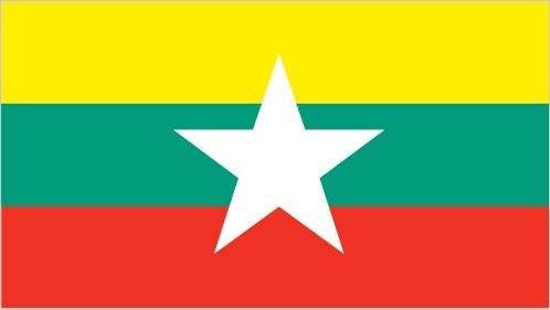
Flag description
design consists of three equal horizontal stripes of yellow (top), green, and red; centered on the green band is a large white five-pointed star that partially overlaps onto the adjacent colored stripes; the design revives the triband colors used by Burma from 1943-45, during the Japanese occupation
National symbol(s)
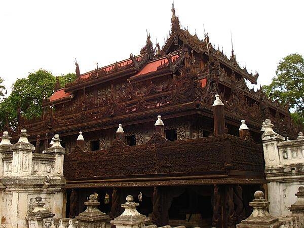
chinthe (mythical lion); national colors: yellow, green, red, white
National anthem
name: "Kaba Ma Kyei" (Till the End of the World, Myanmar)
lyrics/music: SAYA TIN
note: adopted 1948; Burma is among a handful of non-European nations that have anthems rooted in indigenous traditions; the beginning portion of the anthem is a traditional Burmese anthem before transitioning into a Western-style orchestrated work
Economy
Economic overview
Since Burma began the transition to a civilian-led government in 2011, the country initiated economic reforms aimed at attracting foreign investment and reintegrating into the global economy. Burma established a managed float of the Burmese kyat in 2012, granted the Central Bank operational independence in July 2013, enacted a new anti-corruption law in September 2013, and granted licenses to 13 foreign banks in 2014-16. State Counsellor AUNG SAN SUU KYI and the ruling National League for Democracy, who took power in March 2016, have sought to improve Burma’s investment climate following the US sanctions lift in October 2016 and reinstatement of Generalized System of Preferences trade benefits in November 2016. In October 2016, Burma passed a foreign investment law that consolidates investment regulations and eases rules on foreign ownership of businesses.
Burma’s economic growth rate recovered from a low growth under 6% in 2011 but has been volatile between 6% and 8% between 2014 and 2018. Burma’s abundant natural resources and young labor force have the potential to attract foreign investment in the energy, garment, information technology, and food and beverage sectors. The government is focusing on accelerating agricultural productivity and land reforms, modernizing and opening the financial sector, and developing transportation and electricity infrastructure. The government has also taken steps to improve transparency in the mining and oil sectors through publication of reports under the Extractive Industries Transparency Initiative (EITI) in 2016 and 2018.
Despite these improvements, living standards have not improved for the majority of the people residing in rural areas. Burma remains one of the poorest countries in Asia – approximately 26% of the country’s 51 million people live in poverty. The isolationist policies and economic mismanagement of previous governments have left Burma with poor infrastructure, endemic corruption, underdeveloped human resources, and inadequate access to capital, which will require a major commitment to reverse. The Burmese Government has been slow to address impediments to economic development such as unclear land rights, a restrictive trade licensing system, an opaque revenue collection system, and an antiquated banking system.
Real GDP (purchasing power parity)
$247.24 billion note: data are in 2017 dollars (2020 est.)
$274.69 billion note: data are in 2017 dollars (2019 est.)
$270.11 billion note: data are in 2017 dollars (2018 est.)
note: data are in 2010 dollars
Real GDP growth rate
6.8% (2017 est.)
5.9% (2016 est.)
7% (2015 est.)
Real GDP per capita
$4,500 note: data are in 2017 dollars (2020 est.)
$5,100 note: data are in 2017 dollars (2019 est.)
$5,000 note: data are in 2017 dollars (2018 est.)
note: data are in 2017 dollars
GDP (official exchange rate)
$76.606 billion (2019 est.)
Inflation rate (consumer prices)
8.8% (2019 est.)
6.8% (2018 est.)
4.6% (2017 est.)
GDP - composition, by sector of origin
agriculture: 24.1% (2017 est.)
industry: 35.6% (2017 est.)
services: 40.3% (2017 est.)
GDP - composition, by end use
household consumption: 59.2% (2017 est.)
government consumption: 13.8% (2017 est.)
investment in fixed capital: 33.5% (2017 est.)
investment in inventories: 1.5% (2017 est.)
exports of goods and services: 21.4% (2017 est.)
imports of goods and services: -28.6% (2017 est.)
Agricultural products
rice, sugar cane, beans, vegetables, milk, maize, poultry, groundnuts, fruit, plantains
Industries
agricultural processing; wood and wood products; copper, tin, tungsten, iron; cement, construction materials; pharmaceuticals; fertilizer; oil and natural gas; garments; jade and gems
Labor force - by occupation
agriculture: 70%
industry: 7%
services: 23% (2001 est.)
Population below poverty line
24.8% (2017 est.)
Gini Index coefficient - distribution of family income
30.7 (2017 est.)
country comparison to the world: 146Household income or consumption by percentage share
lowest 10%: 2.8%
highest 10%: 32.4% (1998)
Budget
revenues: 9.108 billion (2017 est.)
expenditures: 11.23 billion (2017 est.)
Fiscal year
1 April - 31 March
Current account balance
$240 million (2019 est.)
-$2.398 billion (2018 est.)
Exports
$17.52 billion note: data are in current year dollars (2019 est.)
$15.73 billion note: data are in current year dollars (2018 est.)
note: official export figures are grossly underestimated due to the value of timber, gems, narcotics, rice, and other products smuggled to Thailand, China, and Bangladesh
Exports - partners
China 24%, Thailand 24%, Japan 7%, Germany 5% (2019)
Exports - commodities
natural gas, clothing products, rice, copper, dried legumes (2019)
Imports
$17.36 billion note: data are in current year dollars (2019 est.)
$18.66 billion note: data are in current year dollars (2018 est.)
note: import figures are grossly underestimated due to the value of consumer goods, diesel fuel, and other products smuggled in from Thailand, China, Malaysia, and India
Imports - partners
China 43%, Thailand 15%, Singapore 12%, Indonesia 5% (2019)
Imports - commodities
refined petroleum, broadcasting equipment, fabrics, motorcycles, packaged medicines (2019)
Reserves of foreign exchange and gold
$4.924 billion (31 December 2017 est.)
$4.63 billion (31 December 2016 est.)
Debt - external
$6.594 billion (31 December 2017 est.)
$8.2 billion (31 December 2016 est.)
Exchange rates
kyats (MMK) per US dollar -
1,361.9 (2017 est.)
1,234.87 (2016 est.)
1,234.87 (2015 est.)
1,162.62 (2014 est.)
984.35 (2013 est.)
Unemployment, youth ages 15-24
total: 1.5%
male: 1.4%
female: 1.6% (2019 est.)
Energy
Electricity access
electrification - total population: 51% (2019)
electrification - urban areas: 76% (2019)
electrification - rural areas: 39% (2019)
Electricity - installed generating capacity
5.205 million kW (2016 est.)
country comparison to the world: 79Electricity - from fossil fuels
39% of total installed capacity (2016 est.)
country comparison to the world: 171Electricity - from nuclear fuels
0% of total installed capacity (2017 est.)
country comparison to the world: 58Electricity - from hydroelectric plants
61% of total installed capacity (2017 est.)
country comparison to the world: 28Electricity - from other renewable sources
1% of total installed capacity (2017 est.)
country comparison to the world: 148Refined petroleum products - production
13,330 bbl/day (2017 est.)
country comparison to the world: 97Refined petroleum products - consumption
123,000 bbl/day (2016 est.)
country comparison to the world: 73Natural gas - proved reserves
637.1 billion cu m (1 January 2018 est.)
country comparison to the world: 29Communications
Telephones - fixed lines
total subscriptions: 520,863 (2018)
subscriptions per 100 inhabitants: less than 1 (2018 est.)
Telephones - mobile cellular
total subscriptions: 61,143,964 (2018)
subscriptions per 100 inhabitants: 89.82 (2019 est.)
Telecommunication systems
general assessment: Burma, one of the last underdeveloped telecom markets in Asia, saw growth in mobile and broadband services through foreign competition and roll out of 4G and 5G networks; infrastructure development challenged by flooding, unreliable electricity, inefficient bureaucracy, and corruption; digital divide affects rural areas; fixed broadband remains low due to number of fixed-lines and near saturation of the mobile platform; healthy m-banking platform; tests for NB-IoT; benefit from launch of regional satellite; government utilizes intermittent censorship and shut-down of Internet in political crisis; top importer of broadcasting equipment from China (2021) (2020)
domestic: fixed-line is 1 per 100, while mobile-cellular is 114 per 100 and shows great potential for the future (2019)
international: country code - 95; landing points for the SeaMeWe-3, SeaMeWe-5, AAE-1 and Singapore-Myanmar optical telecommunications submarine cable that provides links to Asia, the Middle East, Africa, Southeast Asia, Australia and Europe; satellite earth stations - 2, Intelsat (Indian Ocean) and ShinSat (2019)
note: the COVID-19 pandemic continues to have a significant impact on production and supply chains globally; since 2020, some aspects of the telecom sector have experienced downturn, particularly in mobile device production; many network operators delayed upgrades to infrastructure; progress towards 5G implementation was postponed or slowed in some countries; consumer spending on telecom services and devices was affected by large-scale job losses and the consequent restriction on disposable incomes; the crucial nature of telecom services as a tool for work and school from home became evident, and received some support from governments
Broadcast media
government controls all domestic broadcast media; 2 state-controlled TV stations with 1 of the stations controlled by the armed forces; 2 pay-TV stations are joint state-private ventures; access to satellite TV is limited; 1 state-controlled domestic radio station and 9 FM stations that are joint state-private ventures; transmissions of several international broadcasters are available in parts of Burma; the Voice of America (VOA), Radio Free Asia (RFA), BBC Burmese service, the Democratic Voice of Burma (DVB), and Radio Australia use shortwave to broadcast in Burma; VOA, RFA, and DVB produce daily TV news programs that are transmitted by satellite to audiences in Burma; in March 2017, the government granted licenses to 5 private broadcasters, allowing them digital free-to-air TV channels to be operated in partnership with government-owned Myanmar Radio and Television (MRTV) and will rely upon MRTV’s transmission infrastructure (2019)
Internet users
total: 23.65 million (2021 est.)
percent of population: 30.68% (2019 est.)
Broadband - fixed subscriptions
total: 129,050 (2018)
subscriptions per 100 inhabitants: less than 1 (201 est.)
Transportation
National air transport system
number of registered air carriers: 8 (2020)
inventory of registered aircraft operated by air carriers: 42
annual passenger traffic on registered air carriers: 3,407,788 (2018)
annual freight traffic on registered air carriers: 4.74 million mt-km (2018)
Airports - with paved runways
total: 36
over 3,047 m: 12
2,438 to 3,047 m: 11
1,524 to 2,437 m: 12
under 914 m: 1 (2017)
Airports - with unpaved runways
total: 28
over 3,047 m: 1
1,524 to 2,437 m: 4
914 to 1,523 m: 10
under 914 m: 13 (2013)
Heliports
11 (2013)
Pipelines
3739 km gas, 1321 km oil (2017)
Railways
total: 5,031 km (2008)
narrow gauge: 5,031 km 1.000-m gauge (2008)
Roadways
total: 157,000 km (2013)
paved: 34,700 km (2013)
unpaved: 122,300 km (2013)
Merchant marine
total: 95
by type: bulk carrier 2, general cargo 39, oil tanker 5, other 49 (2021)
Ports and terminals
major seaport(s): Mawlamyine (Moulmein), Sittwe
river port(s): Rangoon (Yangon) (Rangoon River)
Military and Security
Military and security forces
Burmese Defense Service (Tatmadaw): Army (Tatmadaw Kyi), Navy (Tatmadaw Yay), Air Force (Tatmadaw Lay); People’s Militia; Ministry of Home Affairs: People's Police Force; Border Guard Forces/Police (2021)
note(s) - the Burmese military controls the Ministry of Defense, the Ministry of Border Affairs, and the Ministry of Home Affairs
the armed wing of Burma's pro-democracy movement contains hundreds of local groups of fighters known collectively as the People's Defense Force
Military expenditures
3% of GDP (2020 est.)
2.7% of GDP (2019 est.)
2.9% of GDP (2018 est.)
3.2% of GDP (2017 est.)
3.7% of GDP (2016 est.)
Military and security service personnel strengths
information varies widely; approximately 400,000 total active troops (est. 360,000 Army; 20,000 Navy; 20,000 Air Force) (2021)
Military equipment inventories and acquisitions
the Burmese military inventory is comprised mostly of older Chinese and Russian/Soviet-era equipment with a smaller mix of more modern acquisitions; since 2010, China and Russia are the leading suppliers of military hardware; Burma has a limited defense industry, including a growing shipbuilding capability (2021)
Military service age and obligation
18-35 years of age (men) and 18-27 years of age (women) for voluntary military service; no conscription (a 2010 law reintroducing conscription has not yet entered into force); 2-year service obligation; male (ages 18-45) and female (ages 18-35) professionals (including doctors, engineers, mechanics) serve up to 3 years; service terms may be stretched to 5 years in an officially declared emergency (2021)
Military - note
since the country's founding, the armed forces have been heavily involved in domestic politics and ran the country for five decades following a military coup in 1962; the military controls three key security ministries (Defense, Border, and Home Affairs), one of two vice presidential appointments, 25% of the parliamentary seats, and has a proxy political party, the Union Solidarity and Development Party (USDP)
as of 2021, the military owned and operated two business conglomerates that had over 100 subsidiaries and close ties to other companies; the business activities of these conglomerates included banking and insurance, hotels, tourism, jade and ruby mining, timber, construction, real estate, and the production of palm oil, sugar, soap, cement, beverages, drinking water, coal, and gas; some of the companies supplied goods and services to the military, such as food, clothing, insurance, and cellphone service; the military also managed a film industry, publishing houses, and television stations
as of 2021, the military's primary operational focus was internal security, particularly attempts to quell civilian armed resistance to the coup and counterinsurgency operations against ethnic-based insurgent groups; these operations have resulted in numerous civilian casualties, human rights abuses, and internal displacement
as of 2021, there were approximately 20 ethnic-based armed groups operating in Burma with strengths of a few hundred up to more than 20,000 estimated fighters; they reportedly controlled about one-third of the country’s territory, primarily in the border regions; key groups included the United Wa State Army, Karen National Union, Kachin Independence Army, Arakan Army, Ta’ang National Liberation Army, and the Myanmar Nationalities Democratic Alliance Army
in 2015, the Burmese Government signed a Nationwide Ceasefire Agreement (NCA) with eight mostly small armed groups, including the All Burma Students’ Democratic Front, Arakan Liberation Party, Chin National Front, Democratic Karen Benevolent Army, Karen National Liberation Army-Peace Council, Karen National Union, Pa-O National Liberation Organization, and the Shan State Army-South; seven other groups did not sign the NCA, but have since signed bi-lateral ceasefires with the Burmese Government, including the National Democratic Alliance Army, Shan State Army, New Mon State Army, Karenni Army, National Socialist Council of Nagaland–Khaplang, and the United Wa State Army, which in 2021 was assessed to be the largest and most capable group, with more than 20,000 fighters; others, including the Arakan Army (Chin, Kachin, Rakhine, Shan states), Kachin Independence Army (Kachin state), Myanmar National Democratic Alliance Army (Shan state), Shanni Nationalities Army (Kachin state), and Taang National Liberation Army (Shan state) continued to engage in active insurgent operations against the Burmese Government in 2021; in March 2021, the Karen National Union resumed fighting with the Burmese military
as of 2021, Burma also had a large number (estimates run into the thousands) of armed militias which took many different forms and varied in allegiances and size; most were pro-government and associated with the Tatmadaw; some were integrated within the Tatmadaw’s command structure as Border Guard Forces (BGF); the BGF were organized as 325-man battalions, which included a mix of militia forces, ethnic armed groups, and government soldiers; they were armed, supplied, and paid by the Tatmadaw; other pro-government militias were not integrated within the Tatmadaw command structure, but received direction from the military and were recognized as government militias; the amount of support they received from the Tatmadaw varied depending on local security conditions; the third type of pro-government militias were small community-based units that were armed, coordinated, and trained by local Tatmadaw forces and activated as needed; anti-government militias were typically associated with ethnic-based armed organizations
Transnational Issues
Disputes - international
over half of Burma's population consists of diverse ethnic groups who have substantial numbers of kin in neighboring countries; Bangladesh struggles to accommodate 912,000 Rohingya, Burmese Muslim minority from Rakhine State, living as refugees in Cox's Bazar; Burmese border authorities are constructing a 200 km (124 mi) wire fence designed to deter illegal cross-border transit and tensions from the military build-up along border with Bangladesh in 2010; Bangladesh referred its maritime boundary claims with Burma and India to the International Tribunal on the Law of the Sea; Burmese forces attempting to dig in to the largely autonomous Shan State to rout local militias tied to the drug trade, prompts local residents to periodically flee into neighboring Yunnan Province in China; fencing along the India-Burma international border at Manipur's Moreh town is in progress to check illegal drug trafficking and movement of militants; over 100,000 mostly Karen refugees and asylum seekers fleeing civil strife, political upheaval, and economic stagnation in Burma were living in remote camps in Thailand near the border as of May 2017
Refugees and internally displaced persons
IDPs: 505,000 (government offensives against armed ethnic minority groups near its borders with China and Thailand, natural disasters, forced land evictions) (2020)
stateless persons: 600,000 (2020); note - Rohingya Muslims, living predominantly in Rakhine State, are Burma's main group of stateless people; the Burmese Government does not recognize the Rohingya as a "national race" and stripped them of their citizenship under the 1982 Citizenship Law, categorizing them as "non-nationals" or "foreign residents"; under the Rakhine State Action Plan drafted in October 2014, the Rohingya must demonstrate their family has lived in Burma for at least 60 years to qualify for a lesser naturalized citizenship and the classification of Bengali or be put in detention camps and face deportation; native-born but non-indigenous people, such as Indians, are also stateless; the Burmese Government does not grant citizenship to children born outside of the country to Burmese parents who left the country illegally or fled persecution, such as those born in Thailand; the number of stateless persons has decreased dramatically because hundreds of thousands of Rohingya have fled to Bangladesh since 25 August 2017 to escape violence
note: estimate does not include stateless IDPs or stateless persons in IDP-like situations because they are included in estimates of IDPs (2017)
Trafficking in persons
current situation: human traffickers exploit men, women, and children through forced labor, and women and children in sex trafficking in Burma and abroad; Burmese men are forced to work domestically and abroad in fishing, manufacturing, forestry, agriculture, and construction; fishermen are lured into forced labor in remote waters and offshore by recruitment agencies in Burma and Southeast Asia; Burmese women increasingly are lured to China for marriage under false pretenses and are subjected to sex trafficking, forced concubinage and childbearing, and forced domestic labor; men, women, and children in ethnic minority areas are at increased risk of sex trafficking and forced labor in farming, manufacturing, and construction; men and boys are recruited locally by traffickers for forced labor in oil palm, banana, and rubber plantations, in mining, fishing, and bamboo, teak, rice, and sugarcane harvesting; some military personnel, civilian brokers, border guard officials, and ethnic armed groups continue to recruit child soldiers, particularly in conflict areas
tier rating: Tier 3 — Burma does not fully meet the minimum standards for the elimination of trafficking and is not making significant efforts to do so; authorities increased the investigation and prosecution of trafficking crimes, including those involving officials, and the investigation of forced labor in the fishing sector; the government identified and referred more victims to care and enacted legislation enhancing protections for child victims; however, a policy or pattern of forced labor existed; the use of children in labor and support roles by the military increased in conflict zones in Rakhine and Shan States; displacement resulting from military conflict made Rohingya and other ethnic groups vulnerable to human trafficking; the constitutionally guaranteed power of the military continued to limit the government’s ability to address forced adult labor and child soldier recruitment; although authorities allocated increased funding to victim protection, most services to trafficking victims were provided by NGOs and foreign donors (2020)
Illicit drugs
a major source of illicit methamphetamine and opiates; illicit import of precursor chemicals from China increased production and trafficking of synthetic drugs; second-largest opium poppy cultivator in Asia, with an estimated 20,200 hectares grown in 2019; “Yaba,” a tablet containing methamphetamine, caffeine, and other stimulants, is produced in Burma and trafficked regionally; ethnic armed groups (EAGs), military-affiliated militias, and transnational criminal organizations oversee billion dollar a drug production and trafficking industry; drugs produced in Burma are trafficked beyond Southeast Asia to Australia, New Zealand, and Japan; not a major source or transit country for drugs entering the United States