Eswatini


Introduction
Background
Autonomy for Eswatini was guaranteed by the British in the late 19th century; independence was granted in 1968. A new constitution came into effect in 2006, which included provisions for a more independent parliament and judiciary, but the legal status of political parties remains unclear. King MSWATI III renamed the country from Swaziland to Eswatini in April 2018. Despite its classification as a lower-middle income country, Eswatini suffers from severe poverty and high unemployment. Eswatini has the world's highest HIV/AIDS prevalence rate, although recent years have shown marked declines in new infections.
Visit the Definitions and Notes page to view a description of each topic.
Geography
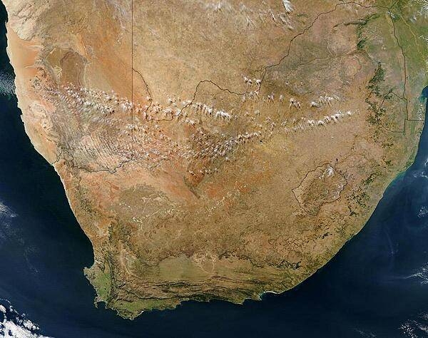
Location
Southern Africa, between Mozambique and South Africa
Geographic coordinates
26 30 S, 31 30 E
Map references
Africa

Land boundaries
total: 546 km
border countries (2): Mozambique 108 km, South Africa 438 km
Coastline
0 km (landlocked)
Maritime claims
none (landlocked)
Climate
varies from tropical to near temperate
Terrain
mostly mountains and hills; some moderately sloping plains
Elevation
highest point: Emlembe 1,862 m
lowest point: Great Usutu River 21 m
mean elevation: 305 m
Natural resources
asbestos, coal, clay, cassiterite, hydropower, forests, small gold and diamond deposits, quarry stone, and talc
Land use
agricultural land: 68.3% (2018 est.)
arable land: 9.8% (2018 est.)
permanent crops: 0.8% (2018 est.)
permanent pasture: 57.7% (2018 est.)
forest: 31.7% (2018 est.)
other: 0% (2018 est.)
Irrigated land
500 sq km (2012)
Population distribution
because of its mountainous terrain, the population distribution is uneven throughout the country, concentrating primarily in valleys and plains as shown in this population distribution map
Natural hazards
drought
Geography - note
landlocked; almost completely surrounded by South Africa
People and Society
Population
1,113,276 (July 2021 est.)
note: estimates for this country explicitly take into account the effects of excess mortality due to AIDS; this can result in lower life expectancy, higher infant mortality, higher death rates, lower population growth rates, and changes in the distribution of population by age and sex than would otherwise be expected
Nationality
noun: liSwati (singular), emaSwati (plural); note - former term, Swazi(s), still used among English speakers
adjective: Swati; note - former term, Swazi, still used among English speakers
Ethnic groups
predominantly Swazi; smaller populations of other African ethnic groups, including the Zulu, as well as people of European ancestry
Languages
English (official, used for government business), siSwati (official)
Religions
Christian 90% (Zionist - a blend of Christianity and indigenous ancestral worship - 40%, Roman Catholic 20%, other 30% - includes Anglican, Methodist, Church of Jesus Christ, Jehovah's Witness), Muslim 2%, other 8% (includes Baha'i, Buddhist, Hindu, indigenous, Jewish) (2015 est.)
Demographic profile
Eswatini, a small, predominantly rural, landlocked country surrounded by South Africa and Mozambique, suffers from severe poverty and the world’s highest HIV/AIDS prevalence rate. A weak and deteriorating economy, high unemployment, rapid population growth, and an uneven distribution of resources all combine to worsen already persistent poverty and food insecurity, especially in rural areas. Erratic weather (frequent droughts and intermittent heavy rains and flooding), overuse of small plots, the overgrazing of cattle, and outdated agricultural practices reduce crop yields and further degrade the environment, exacerbating Eswatini's poverty and subsistence problems. Eswatini's extremely high HIV/AIDS prevalence rate – more than 28% of adults have the disease – compounds these issues. Agricultural production has declined due to HIV/AIDS, as the illness causes households to lose manpower and to sell livestock and other assets to pay for medicine and funerals.
Swazis, mainly men from the country’s rural south, have been migrating to South Africa to work in coal, and later gold, mines since the late 19th century. Although the number of miners abroad has never been high in absolute terms because of Eswatini's small population, the outflow has had important social and economic repercussions. The peak of mining employment in South Africa occurred during the 1980s. Cross-border movement has accelerated since the 1990s, as increasing unemployment has pushed more Swazis to look for work in South Africa (creating a "brain drain" in the health and educational sectors); southern Swazi men have continued to pursue mining, although the industry has downsized. Women now make up an increasing share of migrants and dominate cross-border trading in handicrafts, using the proceeds to purchase goods back in Eswatini. Much of today’s migration, however, is not work-related but focuses on visits to family and friends, tourism, and shopping.
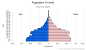
Age structure
0-14 years: 33.63% (male 185,640/female 185,808)
15-24 years: 18.71% (male 98,029/female 108,654)
25-54 years: 39.46% (male 202,536/female 233,275)
55-64 years: 4.36% (male 20,529/female 27,672)
65 years and over: 3.83% (male 15,833/female 26,503) (2020 est.)

Dependency ratios
total dependency ratio: 70.8
youth dependency ratio: 64
elderly dependency ratio: 6.9
potential support ratio: 14.6 (2020 est.)
Median age
total: 23.7 years
male: 22.5 years
female: 24.7 years (2020 est.)
Population distribution
because of its mountainous terrain, the population distribution is uneven throughout the country, concentrating primarily in valleys and plains as shown in this population distribution map
Urbanization
urban population: 24.4% of total population (2021)
rate of urbanization: 2.42% annual rate of change (2020-25 est.)
Major urban areas - population
68,000 MBABANE (capital) (2018)
Sex ratio
at birth: 1.03 male(s)/female
0-14 years: 1 male(s)/female
15-24 years: 0.9 male(s)/female
25-54 years: 0.87 male(s)/female
55-64 years: 0.74 male(s)/female
65 years and over: 0.6 male(s)/female
total population: 0.9 male(s)/female (2020 est.)
Maternal mortality ratio
437 deaths/100,000 live births (2017 est.)
country comparison to the world: 25Infant mortality rate
total: 41.2 deaths/1,000 live births
male: 45.57 deaths/1,000 live births
female: 36.7 deaths/1,000 live births (2021 est.)
Life expectancy at birth
total population: 59.13 years
male: 57.05 years
female: 61.28 years (2021 est.)
Contraceptive prevalence rate
66.1% (2014)
Drinking water source
improved: urban: 96.8% of population
rural: 72.3% of population
total: 78.3% of population
unimproved: urban: 3.2% of population
rural: 27.7% of population
total: 21.7% of population (2017 est.)
Current Health Expenditure
6.5% (2018)
Physicians density
0.33 physicians/1,000 population (2016)
Hospital bed density
2.1 beds/1,000 population (2011)
Sanitation facility access
improved: urban: 93.5% of population
rural: 82.4% of population
total: 85% of population
unimproved: urban: 6.5% of population
rural: 17.6% of population
total: 15% of population (2017 est.)
Major infectious diseases
degree of risk: intermediate (2020)
food or waterborne diseases: bacterial diarrhea, hepatitis A, and typhoid fever
vectorborne diseases: malaria
water contact diseases: schistosomiasis
Literacy
definition: age 15 and over can read and write
total population: 88.4%
male: 88.3%
female: 88.5% (2018)
School life expectancy (primary to tertiary education)
total: 13 years
male: 13 years
female: 12 years (2013)
Unemployment, youth ages 15-24
total: 47.1%
male: 44.2%
female: 50% (2016)
Environment
Environment - current issues
limited supplies of potable water; wildlife populations being depleted because of excessive hunting; population growth, deforestation, and overgrazing lead to soil erosion and soil degradation
Environment - international agreements
party to: Biodiversity, Climate Change, Climate Change-Kyoto Protocol, Climate Change-Paris Agreement, Comprehensive Nuclear Test Ban, Desertification, Endangered Species, Hazardous Wastes, Law of the Sea, Nuclear Test Ban, Ozone Layer Protection, Wetlands
signed, but not ratified: none of the selected agreements
Air pollutants
particulate matter emissions: 16.26 micrograms per cubic meter (2016 est.)
carbon dioxide emissions: 1.16 megatons (2016 est.)
methane emissions: 1.9 megatons (2020 est.)
Climate
varies from tropical to near temperate
Land use
agricultural land: 68.3% (2018 est.)
arable land: 9.8% (2018 est.)
permanent crops: 0.8% (2018 est.)
permanent pasture: 57.7% (2018 est.)
forest: 31.7% (2018 est.)
other: 0% (2018 est.)
Urbanization
urban population: 24.4% of total population (2021)
rate of urbanization: 2.42% annual rate of change (2020-25 est.)
Revenue from forest resources
forest revenues: 2.25% of GDP (2018 est.)
country comparison to the world: 30Major infectious diseases
degree of risk: intermediate (2020)
food or waterborne diseases: bacterial diarrhea, hepatitis A, and typhoid fever
vectorborne diseases: malaria
water contact diseases: schistosomiasis
Food insecurity
severe localized food insecurity: due to the reduction in income-generating activities - the economy is only expected to recover moderately in 2021, following the pandemic-driven contraction in 2020, and households will continue to face food access constraints; an estimated 209,000 people are projected to be food insecure in the April−September 2021 period, down from 347,000 in the January−March 2021 period (2021)
Waste and recycling
municipal solid waste generated annually: 218,199 tons (2016 est.)
Total water withdrawal
municipal: 41.3 million cubic meters (2017 est.)
industrial: 20.7 million cubic meters (2017 est.)
agricultural: 1.006 billion cubic meters (2017 est.)
Total renewable water resources
4.51 billion cubic meters (2017 est.)
Government
Country name
conventional long form: Kingdom of Eswatini
conventional short form: Eswatini
local long form: Umbuso weSwatini
local short form: eSwatini
former: Swaziland
etymology: the country name derives from 19th century King MSWATI II, under whose rule Swati territory was expanded and unified
note: pronounced ay-swatini or eh-swatini
Government type
absolute monarchy
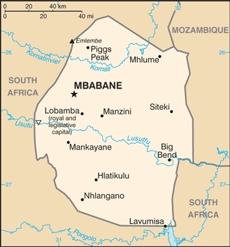
Capital
name: Mbabane (administrative capital); Lobamba (royal and legislative capital)
geographic coordinates: 26 19 S, 31 08 E
time difference: UTC+2 (7 hours ahead of Washington, DC, during Standard Time)
etymology: named after a Swati chief, Mbabane Kunene, who lived in the area at the onset of British settlement
Administrative divisions
4 regions; Hhohho, Lubombo, Manzini, Shiselweni
Independence
6 September 1968 (from the UK)
National holiday
Independence Day (Somhlolo Day), 6 September (1968)
Constitution
history: previous 1968, 1978; latest signed by the king 26 July 2005, effective 8 February 2006
amendments: proposed at a joint sitting of both houses of Parliament; passage requires majority vote by both houses and/or majority vote in a referendum, and assent of the king; passage of amendments affecting "specially entrenched" constitutional provisions requires at least three-fourths majority vote by both houses, passage by simple majority vote in a referendum, and assent of the king; passage of "entrenched" provisions requires at least two-thirds majority vote of both houses, passage in a referendum, and assent of the king
Legal system
mixed legal system of civil, common, and customary law
International law organization participation
accepts compulsory ICJ jurisdiction with reservations; non-party state to the ICCt
Citizenship
citizenship by birth: no
citizenship by descent only: both parents must be citizens of Eswatini
dual citizenship recognized: no
residency requirement for naturalization: 5 years
Suffrage
18 years of age
Executive branch
chief of state: King MSWATI III (since 25 April 1986)
head of government: Prime Minister Cleopas DLAMINI (since since 19 July 2021); Deputy Prime Minister Themba MASUKU (since 6 November 2018)
cabinet: Cabinet recommended by the prime minister, confirmed by the monarch; at least one-half of the cabinet membership must be appointed from among elected members of the House of Assembly
elections/appointments: the monarchy is hereditary; prime minister appointed by the monarch from among members of the House of Assembly
Legislative branch
description: bicameral Parliament (Libandla) consists of:
House of Assembly (73 seats; 59 members directly elected in single-seat constituencies or tinkhundla by absolute majority vote in 2 rounds if needed, 10 members appointed by the monarch, 4 women elected by the members if representation of elected women is less than 30%; members serve 5-year terms)
elections: Senate - last held on 23 October 2018 (next to be held - 31 October 2023)
House of Assembly - last held on 21 September 2018 (next to be held in 2023)
election results: Senate - percent of seats by party - NA; seats by party - NA; composition - men 20, women 10, percent of women 33.3%
House of Assembly - percent of vote by party - NA; seats by party - independent 59; composition - men 60, women 5, percent of women 7.7%; note - total Parliament percent of women 15.8%
Judicial branch
highest courts: Supreme Court (consists of the chief justice and at least 4 justices) and the High Court (consists of the chief justice - ex officio - and 4 justices); note - the Supreme Court has jurisdiction in all constitutional matters
judge selection and term of office: justices of the Supreme Court and High Court appointed by the monarch on the advice of the Judicial Service Commission (JSC), a judicial advisory body consisting of the Supreme Court Chief Justice, 4 members appointed by the monarch, and the chairman of the Civil Service Commission; justices of both courts eligible for retirement at age 65 with mandatory retirement at age 75
subordinate courts: magistrates' courts; National Swazi Courts for administering customary/traditional laws (jurisdiction restricted to customary law for Swazi citizens)
Political parties and leaders
political parties exist, but conditions for their operations, particularly in elections, are undefined, legally unclear, or culturally restricted; the following are considered political associations:
African United Democratic Party or AUDP [Sibusiso DLAMINI]
Ngwane National Liberatory Congress or NNLC [Sibongile MAZIBUKO]
People's United Democratic Movement or PUDEMO [Mlungisi MAKHANYA]
Swazi Democratic Party or SWADEPA [Vacant]
International organization participation
ACP, AfDB, AU, C, COMESA, FAO, G-77, IAEA, IBRD, ICAO, ICRM, IDA, IFAD, IFC, IFRCS, ILO, IMF, IMO, Interpol, IOC, IOM, ISO (correspondent), ITSO, ITU, ITUC (NGOs), MIGA, NAM, OPCW, PCA, SACU, SADC, UN, UNCTAD, UNESCO, UNIDO, UNWTO, UPU, WCO, WHO, WIPO, WMO, WTO
Diplomatic representation in the US
chief of mission: Ambassador Njabuliso Busisiwe Sikhulile GWEBU (since 24 April 2017)
chancery: 1712 New Hampshire Avenue, NW, Washington, DC 20009
telephone: [1] (202) 234-5002
FAX: [1] (202) 234-8254
email address and website:
embassy@swaziland-usa.com; swaziland@compuserve.com
Diplomatic representation from the US
chief of mission: Ambassador Jeanne M. MALONEY (since 4 March 2021)
embassy: Corner of MR 103 and Cultural Center Drive, Ezulwini, P.O. Box D202, The Gables, H106
mailing address: 2350 Mbabane Place, Washington DC 20521-2350
telephone: (268) 2417-9000
FAX: [268] 2416-3344
email address and website:
ConsularMbabane@state.gov
https://sz.usembassy.gov/
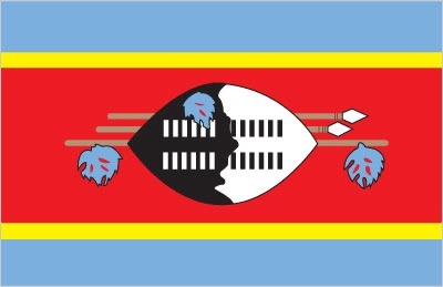
Flag description
three horizontal bands of blue (top), red (triple width), and blue; the red band is edged in yellow; centered in the red band is a large black and white shield covering two spears and a staff decorated with feather tassels, all placed horizontally; blue stands for peace and stability, red represents past struggles, and yellow the mineral resources of the country; the shield, spears, and staff symbolize protection from the country's enemies, while the black and white of the shield are meant to portray black and white people living in peaceful coexistence
National symbol(s)
lion, elephant; national colors: blue, yellow, red
National anthem
name: "Nkulunkulu Mnikati wetibusiso temaSwati" (Oh God, Bestower of the Blessings of the Swazi)
lyrics/music: Andrease Enoke Fanyana SIMELANE/David Kenneth RYCROFT
note: adopted 1968; uses elements of both ethnic Swazi and Western music styles
Economy
Economic overview
A small, landlocked kingdom, Eswatini is bordered in the north, west and south by the Republic of South Africa and by Mozambique in the east. Eswatini depends on South Africa for a majority of its exports and imports. Eswatini's currency is pegged to the South African rand, effectively relinquishing Eswatini's monetary policy to South Africa. The government is dependent on customs duties from the Southern African Customs Union (SACU) for almost half of its revenue. Eswatini is a lower middle income country. As of 2017, more than one-quarter of the adult population was infected by HIV/AIDS; Eswatini has the world’s highest HIV prevalence rate, a financial strain and source of economic instability.
The manufacturing sector diversified in the 1980s and 1990s, but manufacturing has grown little in the last decade. Sugar and soft drink concentrate are the largest foreign exchange earners, although a drought in 2015-16 decreased sugar production and exports. Overgrazing, soil depletion, drought, and floods are persistent problems. Mining has declined in importance in recent years. Coal, gold, diamond, and quarry stone mines are small scale, and the only iron ore mine closed in 2014. With an estimated 28% unemployment rate, Eswatini's need to increase the number and size of small and medium enterprises and to attract foreign direct investment is acute.
Eswatini's national development strategy, which expires in 2022, prioritizes increases in infrastructure, agriculture production, and economic diversification, while aiming to reduce poverty and government spending. Eswatini's revenue from SACU receipts are likely to continue to decline as South Africa pushes for a new distribution scheme, making it harder for the government to maintain fiscal balance without introducing new sources of revenue.
Real GDP (purchasing power parity)
$9.74 billion note: data are in 2017 dollars (2020 est.)
$9.9 billion note: data are in 2017 dollars (2019 est.)
$9.68 billion note: data are in 2017 dollars (2018 est.)
note: data are in 2010 dollars
Real GDP growth rate
1.6% (2017 est.)
1.4% (2016 est.)
0.4% (2015 est.)
Real GDP per capita
$8,400 note: data are in 2017 dollars (2020 est.)
$8,600 note: data are in 2017 dollars (2019 est.)
$8,500 note: data are in 2017 dollars (2018 est.)
note: data are in 2010 dollars
GDP (official exchange rate)
$4.484 billion (2019 est.)
Inflation rate (consumer prices)
6.2% (2017 est.)
7.8% (2016 est.)
Credit ratings
Moody's rating: B3 (2020)
GDP - composition, by sector of origin
agriculture: 6.5% (2017 est.)
industry: 45% (2017 est.)
services: 48.6% (2017 est.)
GDP - composition, by end use
household consumption: 64% (2017 est.)
government consumption: 21.3% (2017 est.)
investment in fixed capital: 13.4% (2017 est.)
investment in inventories: -0.1% (2017 est.)
exports of goods and services: 47.9% (2017 est.)
imports of goods and services: -46.3% (2017 est.)
Agricultural products
sugar cane, maize, roots/tubers nes, grapefruit, oranges, milk, beef, potatoes, vegetables, bananas
Industries
soft drink concentrates, coal, forestry, sugar processing, textiles, and apparel
Labor force - by occupation
agriculture: 10.7%
industry: 30.4%
services: 58.9% (2014 est.)
Population below poverty line
58.9% (2016 est.)
Gini Index coefficient - distribution of family income
54.6 (2016 est.)
country comparison to the world: 5Household income or consumption by percentage share
lowest 10%: 1.7%
highest 10%: 40.1% (2010 est.)
Budget
revenues: 1.263 billion (2017 est.)
expenditures: 1.639 billion (2017 est.)
Fiscal year
1 April - 31 March
Current account balance
$604 million (2017 est.)
$642 million (2016 est.)
Exports
$1.81 billion note: data are in current year dollars (2020 est.)
$2.07 billion note: data are in current year dollars (2019 est.)
$1.9 billion note: data are in current year dollars (2018 est.)
Exports - partners
South Africa 94% (2017)
Exports - commodities
soft drink concentrates, sugar, timber, cotton yarn, refrigerators, citrus, and canned fruit
Imports
$1.7 billion note: data are in current year dollars (2020 est.)
$1.93 billion note: data are in current year dollars (2019 est.)
$2.07 billion note: data are in current year dollars (2018 est.)
Imports - partners
South Africa 81.6%, China 5.2% (2017)
Imports - commodities
motor vehicles, machinery, transport equipment, foodstuffs, petroleum products, chemicals
Reserves of foreign exchange and gold
$563.1 million (31 December 2017 est.)
$564.4 million (31 December 2016 est.)
Exchange rates
emalangeni per US dollar -
14.44 (2017 est.)
14.6924 (2016 est.)
14.6924 (2015 est.)
12.7581 (2014 est.)
10.8469 (2013 est.)
Unemployment, youth ages 15-24
total: 47.1%
male: 44.2%
female: 50% (2016)
Energy
Electricity access
electrification - total population: 90% (2019)
electrification - urban areas: 98% (2019)
electrification - rural areas: 87% (2019)
Electricity - installed generating capacity
295,900 kW (2016 est.)
country comparison to the world: 160Electricity - from fossil fuels
39% of total installed capacity (2016 est.)
country comparison to the world: 172Electricity - from nuclear fuels
0% of total installed capacity (2017 est.)
country comparison to the world: 87Electricity - from hydroelectric plants
20% of total installed capacity (2017 est.)
country comparison to the world: 87Electricity - from other renewable sources
41% of total installed capacity (2017 est.)
country comparison to the world: 5Refined petroleum products - consumption
5,300 bbl/day (2016 est.)
country comparison to the world: 175Communications
Telephones - fixed lines
total subscriptions: 41,000 (2018)
subscriptions per 100 inhabitants: 3.65 (2018 est.)
Telephones - mobile cellular
total subscriptions: 1.052 million (2018)
subscriptions per 100 inhabitants: 93.53 (2019 est.)
Telecommunication systems
general assessment: earlier government monopoly in telecom market hindered growth; liberalized regulators aided expansion in the telecom sector; lack of fixed-line infrastructure and competition stymies development of DSL and backbone network; 2G, 3G, 4G, and LTE services with coverage to most of the population; landlocked country depends on neighbors for international bandwidth; operator completed terrestrial cable linking Maputo through Eswatini to Johannesburg; importer of broadcasting equipment from South Africa (2019)
domestic: Eswatini has 2 mobile-cellular providers; communication infrastructure has a geographic coverage of about 90% and a rising subscriber base; fixed-line stands at 4 per 100 and mobile-cellular teledensity roughly 94 telephones per 100 persons; telephone system consists of carrier-equipped, open-wire lines and low-capacity, microwave radio relay (2019)
international: country code - 268; satellite earth station - 1 Intelsat (Atlantic Ocean)
note: the COVID-19 pandemic continues to have a significant impact on production and supply chains globally; since 2020, some aspects of the telecom sector have experienced downturn, particularly in mobile device production; many network operators delayed upgrades to infrastructure; progress towards 5G implementation was postponed or slowed in some countries; consumer spending on telecom services and devices was affected by large-scale job losses and the consequent restriction on disposable incomes; the crucial nature of telecom services as a tool for work and school from home became evident, and received some support from governments
Broadcast media
1 state-owned TV station; satellite dishes are able to access South African providers; state-owned radio network with 3 channels; 1 private radio station (2019)
Internet users
total: 548,100 (2021 est.)
percent of population: 47% (2019 est.)
Broadband - fixed subscriptions
total: 8,000 (2017 est.)
subscriptions per 100 inhabitants: less than 1 (2017 est.)
Transportation
Airports - with paved runways
total: 2
over 3,047 m: 1
2,438 to 3,047 m: 1 (2019)
Airports - with unpaved runways
total: 12
914 to 1,523 m: 5
under 914 m: 7 (2013)
Railways
total: 301 km (2014)
narrow gauge: 301 km 1.067-m gauge (2014)
Military and Security
Military and security forces
Umbutfo Eswatini Defense Force (UEDF): Army (includes a small air wing) (2021)
Military expenditures
1.8% of GDP (2020 est.)
1.8% of GDP (2019 est.)
1.9% of GDP (2018 est.)
1.9% of GDP (2017 est.)
2% of GDP (2016 est.)
Military and security service personnel strengths
the Umbutfo Eswatini Defense Force has approximately 3,000 active personnel (2020)
Military equipment inventories and acquisitions
the UEDF is lightly armed with mostly South African material; it has received minimal amounts of secondhand equipment since 2010 (2021)
Military service age and obligation
18-30 years of age for male and female voluntary military service; no conscription; compulsory HIV testing required, only HIV-negative applicants accepted (2019)
Military - note
the UEDF was originally created in 1973 as the Royal Swaziland Defense Force; as of 2021, the UEDF’s primary mission was external security but it also had domestic security responsibilities, including protecting members of the royal family; the king is the UEDF commander in chief and holds the position of minister of defense, although the UEDF reports to the Army commander and principal undersecretary of defense for day-to-day operations; the Royal Eswatini Police Service (REPS) is responsible for maintaining internal security as well as migration and border crossing enforcement; it is under the prime minister, although the king is the force’s titular commissioner in chief
Transnational Issues
Disputes - international
in 2006, Swati king advocated resorting to ICJ to claim parts of Mpumalanga and KwaZulu-Natal from South Africa