


Introduction
Background
Once part of Spain's vast empire in the New World, Honduras became an independent nation in 1821. After two and a half decades of mostly military rule, a freely elected civilian government came to power in 1982. During the 1980s, Honduras proved a haven for anti-Sandinista contras fighting the Marxist Nicaraguan Government and an ally to Salvadoran Government forces fighting leftist guerrillas. The country was devastated by Hurricane Mitch in 1998, which killed about 5,600 people and caused approximately $2 billion in damage. Since then, the economy has slowly rebounded.
Visit the Definitions and Notes page to view a description of each topic.
Geography
Location
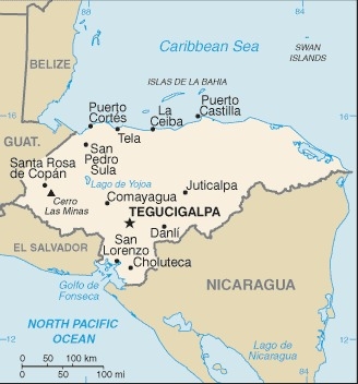
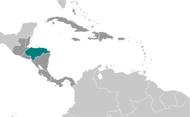
Central America, bordering the Caribbean Sea, between Guatemala and Nicaragua and bordering the Gulf of Fonseca (North Pacific Ocean), between El Salvador and Nicaragua
Geographic coordinates
15 00 N, 86 30 W
Map references
Central America and the Caribbean


Land boundaries
total: 1,575 km
border countries (3): Guatemala 244 km, El Salvador 391 km, Nicaragua 940 km
Coastline
823 km (Caribbean Sea 669 km, Gulf of Fonseca 163 km)
Maritime claims
territorial sea: 12 nm
contiguous zone: 24 nm
exclusive economic zone: 200 nm
continental shelf: natural extension of territory or to 200 nm
Climate
subtropical in lowlands, temperate in mountains
Terrain
mostly mountains in interior, narrow coastal plains
Elevation
highest point: Cerro Las Minas 2,870 m
lowest point: Caribbean Sea 0 m
mean elevation: 684 m
Natural resources
timber, gold, silver, copper, lead, zinc, iron ore, antimony, coal, fish, hydropower
Land use
agricultural land: 28.8% (2018 est.)
arable land: 9.1% (2018 est.)
permanent crops: 4% (2018 est.)
permanent pasture: 15.7% (2018 est.)
forest: 45.3% (2018 est.)
other: 25.9% (2018 est.)
Irrigated land
900 sq km (2012)
Major lakes (area sq km)
Salt water lake(s): Laguna de Caratasca - 1,110 sq km
Population distribution
most residents live in the mountainous western half of the country; unlike other Central American nations, Honduras is the only one with an urban population that is distributed between two large centers - the capital of Tegucigalpa and the city of San Pedro Sula; the Rio Ulua valley in the north is the only densely populated lowland area
Natural hazards
frequent, but generally mild, earthquakes; extremely susceptible to damaging hurricanes and floods along the Caribbean coast
Geography - note
has only a short Pacific coast but a long Caribbean shoreline, including the virtually uninhabited eastern Mosquito Coast
People and Society
Population
9,346,277 (July 2021 est.)
note: estimates for this country explicitly take into account the effects of excess mortality due to AIDS; this can result in lower life expectancy, higher infant mortality, higher death rates, lower population growth rates, and changes in the distribution of population by age and sex than would otherwise be expected
Nationality
noun: Honduran(s)
adjective: Honduran
Ethnic groups
Mestizo (mixed Amerindian and European) 90%, Amerindian 7%, African descent 2%, White 1%
Languages
Spanish (official), Amerindian dialects
major-language sample(s):
La Libreta Informativa del Mundo, la fuente indispensable de información básica. (Spanish)
The World Factbook, the indispensable source for basic information.
Religions
Roman Catholic 46%, Protestant 41%, atheist 1%, other 2%, none 9% (2014 est.)
Demographic profile
Honduras is one of the poorest countries in Latin America and has one of the world's highest murder rates. More than half of the population lives in poverty and per capita income is one of the lowest in the region. Poverty rates are higher among rural and indigenous people and in the south, west, and along the eastern border than in the north and central areas where most of Honduras' industries and infrastructure are concentrated. The increased productivity needed to break Honduras' persistent high poverty rate depends, in part, on further improvements in educational attainment. Although primary-school enrollment is near 100%, educational quality is poor, the drop-out rate and grade repetition remain high, and teacher and school accountability is low.
Honduras' population growth rate has slowed since the 1990s and is now 1.2% annually with a birth rate that averages 2.1 children per woman and more among rural, indigenous, and poor women. Honduras' young adult population - ages 15 to 29 - is projected to continue growing rapidly for the next three decades and then stabilize or slowly shrink. Population growth and limited job prospects outside of agriculture will continue to drive emigration. Remittances represent about a fifth of GDP.
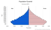
Age structure
0-14 years: 30.2% (male 1,411,537/female 1,377,319)
15-24 years: 21.03% (male 969,302/female 972,843)
25-54 years: 37.79% (male 1,657,260/female 1,832,780)
55-64 years: 5.58% (male 233,735/female 281,525)
65 years and over: 5.4% (male 221,779/female 277,260) (2020 est.)

Dependency ratios
total dependency ratio: 55.2
youth dependency ratio: 47.5
elderly dependency ratio: 7.7
potential support ratio: 13 (2020 est.)
Median age
total: 24.4 years
male: 23.5 years
female: 25.2 years (2020 est.)
Population distribution
most residents live in the mountainous western half of the country; unlike other Central American nations, Honduras is the only one with an urban population that is distributed between two large centers - the capital of Tegucigalpa and the city of San Pedro Sula; the Rio Ulua valley in the north is the only densely populated lowland area
Urbanization
urban population: 59% of total population (2021)
rate of urbanization: 2.48% annual rate of change (2020-25 est.)
Major urban areas - population
1.485 million TEGUCIGALPA (capital), 929,000 San Pedro Sula (2021)
Sex ratio
at birth: 1.03 male(s)/female
0-14 years: 1.02 male(s)/female
15-24 years: 1 male(s)/female
25-54 years: 0.9 male(s)/female
55-64 years: 0.83 male(s)/female
65 years and over: 0.8 male(s)/female
total population: 0.95 male(s)/female (2020 est.)
Mother's mean age at first birth
20.3 years (2011/12 est.)
note: median age a first birth among women 25-49
Maternal mortality ratio
65 deaths/100,000 live births (2017 est.)
country comparison to the world: 86Infant mortality rate
total: 15.39 deaths/1,000 live births
male: 17.52 deaths/1,000 live births
female: 13.19 deaths/1,000 live births (2021 est.)
Life expectancy at birth
total population: 74.9 years
male: 71.34 years
female: 78.58 years (2021 est.)
Contraceptive prevalence rate
73.2% (2011/12)
Drinking water source
improved: urban: 100% of population
rural: 88.9% of population
total: 94.8% of population
unimproved: urban: 0% of population
rural: 11.1% of population
total: 5.2% of population (2017 est.)
Current Health Expenditure
7.1% (2018)
Physicians density
0.31 physicians/1,000 population (2017)
Hospital bed density
0.6 beds/1,000 population (2017)
Sanitation facility access
improved: urban: 95.4% of population
rural: 83.5% of population
total: 90.2% of population
unimproved: urban: 4.6% of population
rural: 16.5% of population
total: 9.8% of population (2017 est.)
HIV/AIDS - deaths
<1000 (2020 est.)
Major infectious diseases
degree of risk: high (2020)
food or waterborne diseases: bacterial diarrhea, hepatitis A, and typhoid fever
vectorborne diseases: dengue fever and malaria
Literacy
definition: age 15 and over can read and write
total population: 88.5%
male: 88.2%
female: 88.7% (2019)
School life expectancy (primary to tertiary education)
total: 10 years
male: 10 years
female: 11 years (2019)
Unemployment, youth ages 15-24
total: 17.8%
male: 11.1%
female: 27.7% (2020 est.)
Environment
Environment - current issues
urban population expanding; deforestation results from logging and the clearing of land for agricultural purposes; further land degradation and soil erosion hastened by uncontrolled development and improper land use practices such as farming of marginal lands; mining activities polluting Lago de Yojoa (the country's largest source of fresh water), as well as several rivers and streams, with heavy metals
Environment - international agreements
party to: Biodiversity, Climate Change, Climate Change-Kyoto Protocol, Climate Change-Paris Agreement, Comprehensive Nuclear Test Ban, Desertification, Endangered Species, Environmental Modification, Hazardous Wastes, Law of the Sea, Marine Dumping-London Convention, Nuclear Test Ban, Ozone Layer Protection, Ship Pollution, Tropical Timber 2006, Wetlands
signed, but not ratified: none of the selected agreements
Air pollutants
particulate matter emissions: 20.12 micrograms per cubic meter (2016 est.)
carbon dioxide emissions: 9.81 megatons (2016 est.)
methane emissions: 7.72 megatons (2020 est.)
Climate
subtropical in lowlands, temperate in mountains
Land use
agricultural land: 28.8% (2018 est.)
arable land: 9.1% (2018 est.)
permanent crops: 4% (2018 est.)
permanent pasture: 15.7% (2018 est.)
forest: 45.3% (2018 est.)
other: 25.9% (2018 est.)
Urbanization
urban population: 59% of total population (2021)
rate of urbanization: 2.48% annual rate of change (2020-25 est.)
Revenue from forest resources
forest revenues: 0.91% of GDP (2018 est.)
country comparison to the world: 54Major infectious diseases
degree of risk: high (2020)
food or waterborne diseases: bacterial diarrhea, hepatitis A, and typhoid fever
vectorborne diseases: dengue fever and malaria
Waste and recycling
municipal solid waste generated annually: 2,162,028 tons (2016 est.)
Major lakes (area sq km)
Salt water lake(s): Laguna de Caratasca - 1,110 sq km
Total water withdrawal
municipal: 315 million cubic meters (2017 est.)
industrial: 114 million cubic meters (2017 est.)
agricultural: 1.178 billion cubic meters (2017 est.)
Total renewable water resources
92.164 billion cubic meters (2017 est.)
Government
Country name
conventional long form: Republic of Honduras
conventional short form: Honduras
local long form: Republica de Honduras
local short form: Honduras
etymology: the name means "depths" in Spanish and refers to the deep anchorage in the northern Bay of Trujillo
Government type
presidential republic
Capital
name: Tegucigalpa; note - article eight of the Honduran constitution states that the twin cities of Tegucigalpa and Comayaguela, jointly, constitute the capital of the Republic of Honduras; however, virtually all governmental institutions are on the Tegucigalpa side, which in practical terms makes Tegucigalpa the capital
geographic coordinates: 14 06 N, 87 13 W
time difference: UTC-6 (1 hour behind Washington, DC during Standard Time)
etymology: while most sources agree that Tegucigalpa is of Nahuatl derivation, there is no consensus on its original meaning
Administrative divisions
18 departments (departamentos, singular - departamento); Atlantida, Choluteca, Colon, Comayagua, Copan, Cortes, El Paraiso, Francisco Morazan, Gracias a Dios, Intibuca, Islas de la Bahia, La Paz, Lempira, Ocotepeque, Olancho, Santa Barbara, Valle, Yoro
Independence
15 September 1821 (from Spain)
National holiday
Independence Day, 15 September (1821)
Constitution
history: several previous; latest approved 11 January 1982, effective 20 January 1982
amendments: proposed by the National Congress with at least two-thirds majority vote of the membership; passage requires at least two-thirds majority vote of Congress in its next annual session; constitutional articles, such as the form of government, national sovereignty, the presidential term, and the procedure for amending the constitution, cannot be amended; amended several times, last in 2021
Legal system
civil law system
International law organization participation
accepts compulsory ICJ jurisdiction with reservations; accepts ICCt jurisdiction
Citizenship
citizenship by birth: yes
citizenship by descent only: yes
dual citizenship recognized: yes
residency requirement for naturalization: 1 to 3 years
Suffrage
18 years of age; universal and compulsory
Executive branch
chief of state: President Juan Orlando HERNANDEZ Alvarado (since 27 January 2014); Vice Presidents Ricardo ALVAREZ, Maria RIVERA, and Olga ALVARADO (since 26 January 2018); note - the president is both chief of state and head of government
head of government: President Juan Orlando HERNANDEZ Alvarado (since 27 January 2014); Vice Presidents Ricardo ALVAREZ, Maria RIVERA, and Olga ALVARADO (since 26 January 2018)
cabinet: Cabinet appointed by president
elections/appointments: president directly elected by simple majority popular vote for a 4-year term; election last held on 28 November 2021 (next to be held in 30 November 2025); note - in 2015, the Constitutional Chamber of the Honduran Supreme Court struck down the constitutional provisions on presidential term limits
election results:
2021: Xiomara CASTRO de Zelaya elected president; percent of vote - Xiomara CASTRO de Zelaya (LIBRE) 51.1%, Nasry Juan ASFURA Zablah (PNH) 36.9%, Yani Benjamin ROSENTHAL Hidalgo (PL) 10%, other 2%; note - CASTRO will take office 27 January 2022
2017: Juan Orlando HERNANDEZ Alvarado reelected president; percent of vote - Juan Orlando HERNANDEZ Alvarado (PNH) 43%, Salvador NASRALLA (Alianza de Oposicion contra la Dictadura) 41.4%, Luis Orlando ZELAYA Medrano (PL) 14.7%, other 0.9%
Legislative branch
description: unicameral National Congress or Congreso Nacional (128 seats; members directly elected in 18 multi-seat constituencies by closed party-list proportional representation vote; members serve 4-year terms)
elections: last held on 28 November 2021 (next to be held on 30 November 2025)
election results: percent of vote by party - LIBRE 39.8%, PNH 31.3%, PL 16.4%, PSH 10.9%, DC 0.8%, PAC 0.8%; seats by bloc or party - LIBRE 51, PNH 40, PL 21, PSH 14, DC 1, PAC 1
Judicial branch
highest courts: Supreme Court of Justice or Corte Suprema de Justicia (15 principal judges, including the court president, and 7 alternates; court organized into civil, criminal, constitutional, and labor chambers); note - the court has both judicial and constitutional jurisdiction
judge selection and term of office: court president elected by his peers; judges elected by the National Congress from candidates proposed by the Nominating Board, a diverse 7-member group of judicial officials and other government and non-government officials nominated by each of their organizations; judges elected by Congress for renewable, 7-year terms
subordinate courts: courts of appeal; courts of first instance; justices of the peace
Political parties and leaders
Anti-Corruption Party or PAC [Marlene ALVARENGA]
Christian Democratic Party or DC [Lucas AGUILERA]
Democratic Unification Party or UD [Alfonso DIAZ]
Honduran Patriotic Alliance or AP [Romeo VASQUEZ Velasquez]
Innovation and Unity Party or PINU [Guillermo VALLE]
Liberal Party or PL [Yani Benjamin ROSENTHAL Hidalgo]
Liberty and Refoundation Party or LIBRE [Jose Manuel ZELAYA Rosales]
National Party of Honduras or PNH [Reinaldo SANCHEZ Rivera]
Opposition Alliance against the Dictatorship or Alianza de Oposicion contra la Dictadura [Salvador NASRALLA] (electoral coalition)
Savior Party of Honduras or PSH [Salvador Alejandro Cesar NASRALLA Salum]
International organization participation
BCIE, CACM, CD, CELAC, EITI (candidate country), FAO, G-11, G-77, IADB, IAEA, IBRD, ICAO, ICCt, ICRM, IDA, IFAD, IFC, IFRCS, ILO, IMF, IMO, Interpol, IOC (suspended), IOM, IPU, ISO (subscriber), ITSO, ITU, ITUC (NGOs), LAES, LAIA (observer), MIGA, MINURSO, MINUSTAH, NAM, OAS, OPANAL, OPCW, Pacific Alliance (observer), PCA, Petrocaribe, SICA, UN, UNCTAD, UNESCO, UNIDO, Union Latina, UNWTO, UPU, WCO (suspended), WFTU (NGOs), WHO, WIPO, WMO, WTO
Diplomatic representation in the US
chief of mission: Ambassador Luis Fernando SUAZO BARAHONA (since 17 September 2020)
chancery: 1220 19th Street NW, Suite #320, Washington, DC 20036
telephone: [1] (202) 966-7702
FAX: [1] (202) 966-9751
email address and website:
https://hondurasembusa.org/
consulate(s) general: Atlanta, Chicago, Houston, Los Angeles, Miami, New Orleans, New York, San Francisco
consulate(s): Dallas, McAllen (TX)
Diplomatic representation from the US
chief of mission: Ambassador (vacant); Charge d'Affaires Colleen A. HOEY (since August 2019)
embassy: Avenida La Paz, Tegucigalpa M.D.C.
mailing address: 3480 Tegucigalpa Place, Washington DC 20521-3480
telephone: [504] 2236-9320,
FAX: [504] 2236-9037
email address and website:
usahonduras@state.gov
https://hn.usembassy.gov/
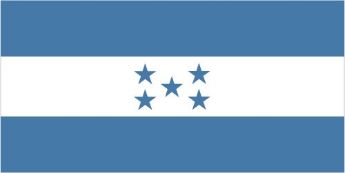
Flag description
three equal horizontal bands of cerulean blue (top), white, and cerulean blue, with five cerulean, five-pointed stars arranged in an X pattern centered in the white band; the stars represent the members of the former Federal Republic of Central America: Costa Rica, El Salvador, Guatemala, Honduras, and Nicaragua; the blue bands symbolize the Pacific Ocean and the Caribbean Sea; the white band represents the land between the two bodies of water and the peace and prosperity of its people
note: similar to the flag of El Salvador, which features a round emblem encircled by the words REPUBLICA DE EL SALVADOR EN LA AMERICA CENTRAL centered in the white band; also similar to the flag of Nicaragua, which features a triangle encircled by the words REPUBLICA DE NICARAGUA on top and AMERICA CENTRAL on the bottom, centered in the white band
National symbol(s)
scarlet macaw, white-tailed deer; national colors: blue, white
National anthem
name: "Himno Nacional de Honduras" (National Anthem of Honduras)
lyrics/music: Augusto Constancio COELLO/Carlos HARTLING
note: adopted 1915; the anthem's seven verses chronicle Honduran history; on official occasions, only the chorus and last verse are sung
Economy
Economic overview
Honduras, the second poorest country in Central America, suffers from extraordinarily unequal distribution of income, as well as high underemployment. While historically dependent on the export of bananas and coffee, Honduras has diversified its export base to include apparel and automobile wire harnessing.
Honduras’s economy depends heavily on US trade and remittances. The US-Central America-Dominican Republic Free Trade Agreement came into force in 2006 and has helped foster foreign direct investment, but physical and political insecurity, as well as crime and perceptions of corruption, may deter potential investors; about 15% of foreign direct investment is from US firms.
The economy registered modest economic growth of 3.1%-4.0% from 2010 to 2017, insufficient to improve living standards for the nearly 65% of the population in poverty. In 2017, Honduras faced rising public debt, but its economy has performed better than expected due to low oil prices and improved investor confidence. Honduras signed a three-year standby arrangement with the IMF in December 2014, aimed at easing Honduras’s poor fiscal position.
Real GDP (purchasing power parity)
$50.89 billion note: data are in 2017 dollars (2020 est.)
$55.91 billion note: data are in 2017 dollars (2019 est.)
$54.46 billion note: data are in 2017 dollars (2018 est.)
note: data are in 2017 dollars
Real GDP growth rate
4.8% (2017 est.)
3.8% (2016 est.)
3.8% (2015 est.)
Real GDP per capita
$5,100 note: data are in 2017 dollars (2020 est.)
$5,700 note: data are in 2017 dollars (2019 est.)
$5,700 note: data are in 2017 dollars (2018 est.)
note: data are in 2017 dollars
GDP (official exchange rate)
$25.145 billion (2019 est.)
Inflation rate (consumer prices)
4.3% (2019 est.)
4.3% (2018 est.)
3.9% (2017 est.)
Credit ratings
Moody's rating: B1 (2017)
Standard & Poors rating: BB- (2017)
GDP - composition, by sector of origin
agriculture: 14.2% (2017 est.)
industry: 28.8% (2017 est.)
services: 57% (2017 est.)
GDP - composition, by end use
household consumption: 77.7% (2017 est.)
government consumption: 13.8% (2017 est.)
investment in fixed capital: 23.1% (2017 est.)
investment in inventories: 0.7% (2017 est.)
exports of goods and services: 43.6% (2017 est.)
imports of goods and services: -58.9% (2017 est.)
Agricultural products
sugarcane, oil palm fruit, milk, bananas, maize, coffee, melons, oranges, poultry, beans
Industries
sugar processing, coffee, woven and knit apparel, wood products, cigars
Labor force - by occupation
agriculture: 39.2%
industry: 20.9%
services: 39.8% (2005 est.)
Unemployment rate
5.6% (2017 est.)
6.3% (2016 est.)
note: about one-third of the people are underemployed
Population below poverty line
48.3% (2018 est.)
Gini Index coefficient - distribution of family income
52.1 (2018 est.)
45.7 (2009)
Household income or consumption by percentage share
lowest 10%: 1.2%
highest 10%: 38.4% (2014)
Budget
revenues: 4.658 billion (2017 est.)
expenditures: 5.283 billion (2017 est.)
Fiscal year
calendar year
Current account balance
-$380 million (2017 est.)
-$587 million (2016 est.)
Exports
$7.16 billion note: data are in current year dollars (2019 est.)
$7.14 billion note: data are in current year dollars (2018 est.)
Exports - partners
United States 53%, El Salvador 8%, Guatemala 5%, Nicaragua 5% (2019)
Exports - commodities
clothing and apparel, coffee, insulated wiring, bananas, palm oil (2019)
Imports
$11.5 billion note: data are in current year dollars (2019 est.)
$11.78 billion note: data are in current year dollars (2018 est.)
Imports - partners
United States 42%, China 10%, Guatemala 8%, El Salvador 8%, Mexico 6% (2019)
Imports - commodities
refined petroleum, clothing and apparel, packaged medicines, broadcasting equipment, insulated wiring (2019)
Reserves of foreign exchange and gold
$4.708 billion (31 December 2017 est.)
$3.814 billion (31 December 2016 est.)
Debt - external
$9.137 billion (2019 est.)
$8.722 billion (2018 est.)
Exchange rates
lempiras (HNL) per US dollar -
23.74 (2017 est.)
22.995 (2016 est.)
22.995 (2015 est.)
22.098 (2014 est.)
21.137 (2013 est.)
Unemployment, youth ages 15-24
total: 17.8%
male: 11.1%
female: 27.7% (2020 est.)
Energy
Electricity access
electrification - total population: 81% (2019)
electrification - urban areas: 91% (2019)
electrification - rural areas: 68% (2019)
Electricity - installed generating capacity
2.546 million kW (2016 est.)
country comparison to the world: 108Electricity - from fossil fuels
40% of total installed capacity (2016 est.)
country comparison to the world: 169Electricity - from nuclear fuels
0% of total installed capacity (2017 est.)
country comparison to the world: 107Electricity - from hydroelectric plants
25% of total installed capacity (2017 est.)
country comparison to the world: 77Electricity - from other renewable sources
34% of total installed capacity (2017 est.)
country comparison to the world: 10Refined petroleum products - consumption
59,000 bbl/day (2016 est.)
country comparison to the world: 97Communications
Telephones - fixed lines
total subscriptions: 531,763 (2020)
subscriptions per 100 inhabitants: 5.37 (2020 est.)
Telephones - mobile cellular
total subscriptions: 6,960,654 (2020)
subscriptions per 100 inhabitants: 70.28 (2020 est.)
Telecommunication systems
general assessment:
among the poorest countries in Central America, Honduras has a neglected telecom sector complicated by political stalemate and geographic challenges; mobile subscribership is growing; DSL and cable Internet available in urban areas but expensive; government proposed ICT master plan to boost e-government and business, including free Internet to households; US based network ready to deploy 5G
domestic: private sub-operators allowed to provide fixed lines in order to expand telephone coverage contributing to a small increase in fixed-line teledensity 5 per 100; mobile-cellular subscribership is roughly 73 per 100 persons (2019)
international: country code - 504; landing points for both the ARCOS and the MAYA-1 fiber-optic submarine cable systems that together provide connectivity to South and Central America, parts of the Caribbean, and the US; satellite earth stations - 2 Intelsat (Atlantic Ocean); connected to Central American Microwave System (2019)
note: the COVID-19 pandemic continues to have a significant impact on production and supply chains globally; since 2020, some aspects of the telecom sector have experienced downturn, particularly in mobile device production; many network operators delayed upgrades to infrastructure; progress towards 5G implementation was postponed or slowed in some countries; consumer spending on telecom services and devices was affected by large-scale job losses and the consequent restriction on disposable incomes; the crucial nature of telecom services as a tool for work and school from home became evident, and received some support from governments
Broadcast media
multiple privately owned terrestrial TV networks, supplemented by multiple cable TV networks; Radio Honduras is the lone government-owned radio network; roughly 300 privately owned radio stations
Internet users
total: 3.81 million (2021 est.)
percent of population: 31.7% (2019 est.)
Broadband - fixed subscriptions
total: 396,454 (2020)
subscriptions per 100 inhabitants: 4 (2020 est.)
Transportation
National air transport system
number of registered air carriers: 4 (2020)
inventory of registered aircraft operated by air carriers: 26
annual passenger traffic on registered air carriers: 251,149 (2018)
annual freight traffic on registered air carriers: 450,000 mt-km (2018)
Airports - with paved runways
total: 13
2,438 to 3,047 m: 3
1,524 to 2,437 m: 3
914 to 1,523 m: 4
under 914 m: 3 (2017)
Airports - with unpaved runways
total: 90
1,524 to 2,437 m: 1
914 to 1,523 m: 16
under 914 m: 73 (2013)
Railways
total: 699 km (2014)
narrow gauge: 164 km 1.067-m gauge (2014)
115 km 1.057-m gauge
420 km 0.914-m gauge
Roadways
total: 14,742 km (2012)
paved: 3,367 km (2012)
unpaved: 11,375 km (1,543 km summer only) (2012)
note: an additional 8,951 km of non-official roads used by the coffee industry
Merchant marine
total: 505
by type: bulk carrier 1, general cargo 244, oil tanker 82, other 178 (2021)
Ports and terminals
major seaport(s): La Ceiba, Puerto Cortes, San Lorenzo, Tela
Military and Security
Military and security forces
Honduran Armed Forces (Fuerzas Armadas de Honduras, FFAA): Army (Ejercito), Honduran Naval Force (FNH; includes marines), Honduran Air Force (Fuerza Aerea Hondurena, FAH), Honduran Public Order Military Police (PMOP); Security Secretariat: Public Security Forces (includes Honduran National Police paramilitary units) (2021)
note - the PMOP was created in 2013 as part of an effort by the Honduran Government to expand the military’s role in law enforcement alongside the Honduran National Police (HNP), particularly against narcotics trafficking and organized crime; since its creation, the PMOP’s role in internal security has expanded; it was used against election protesters in 2017, for example, and it has been accused of human rights violations; as of 2021, the PMOP was composed of 8 battalions of military personnel (approximately 5,000 troops) who have undergone some police training; it reported to military authorities but conducts operations sanctioned by both civilian security officials and military leaders
Military expenditures
1.7% of GDP (2020 est.)
1.6% of GDP (2019)
1.6% of GDP (2018)
1.7% of GDP (2017)
1.7% of GDP (2016)
Military and security service personnel strengths
the Honduran Armed Forces (FFAA) have approximately 16,000 active personnel (7,500 Army; 1,500 Navy, including about 1,000 marines; 2,000 Air Force; 5,000 Public Order Military Police); approximately 18,000 National Police (2021)
Military equipment inventories and acquisitions
the FFAA's inventory is comprised of mostly older imported equipment from Israel, the UK, and the US; since 2010, Honduras has received limited amounts of military equipment from several countries, including Colombia, Israel, Netherlands, Taiwan, and the US (2021)
Military service age and obligation
18 years of age for voluntary 2- to 3-year military service; no conscription (2021)
Military - note
the armed forces, including the PMOP, are subordinate to the Secretariat of Defense, while the HNP reports to the Secretariat of Security; the National Interinstitutional Security Force is an interagency command that coordinates the overlapping responsibilities of the HNP, PMOP, National Intelligence Directorate, and Public Ministry (public prosecutor), but exercises coordination, command, and control responsibilities only during interagency operations involving those forces; as of 2021, civilian authorities at times reportedly did not maintain effective control over security forces
Transnational Issues
Disputes - international
International Court of Justice (ICJ) ruled on the delimitation of "bolsones" (disputed areas) along the El Salvador-Honduras border in 1992 with final settlement by the parties in 2006 after an Organization of American States survey and a further ICJ ruling in 2003; the 1992 ICJ ruling advised a tripartite resolution to a maritime boundary in the Gulf of Fonseca with consideration of Honduran access to the Pacific; El Salvador continues to claim tiny Conejo Island, not mentioned in the ICJ ruling, off Honduras in the Gulf of Fonseca; Honduras claims the Belizean-administered Sapodilla Cays off the coast of Belize in its constitution, but agreed to a joint ecological park around the cays should Guatemala consent to a maritime corridor in the Caribbean under the OAS-sponsored 2002 Belize-Guatemala Differendum
Refugees and internally displaced persons
IDPs: 247,000 (violence, extortion, threats, forced recruitment by urban gangs between 2004 and 2018) (2020)
Illicit drugs
transshipment point for cocaine destined for the United States and precursor chemicals used to produce illicit drugs; some experimental coca cultivation