Sierra Leone


Introduction
Background
Continuously populated for at least 2,500 years, the dense jungle in the area of Sierra Leone allowed the region to remain relatively protected from invaders from empires in West Africa. Traders introduced Sierra Leone to Islam, which occupies a central role in Sierra Leonean culture and history. In the 17th century, the British set up a trading post near present-day Freetown. The trade originally involved timber and ivory, but later expanded to enslaved people. In 1787, following the American Revolution, Sierra Leone became a destination for black British loyalists from the new United States. After the abolition of the slave trade in 1807, British ships delivered thousands of liberated Africans to Sierra Leone. During the 19th century, the colony gradually expanded inland.
In 1961, Sierra Leone became independent of the UK. While Sierra Leone held free and fair elections in 1962 and 1967, Siaka STEVENS - Sierra Leone’s second prime minister - quickly reverted to authoritarian tendencies, outlawing most political parties and ruling from 1967 to 1985. In 1991, Sierra Leonean soldiers launched a civil war against STEVENS’ ruling party. The war caused tens of thousands of deaths and displaced more than 2 million people (about one-third of the population). In 1998, a Nigerian-led West African coalition military force intervened, installing Tejan KABBAH - who was originally elected in 1996 - as prime minister. In 2002, KABBAH officially announced the end of the war. Since 1998, Sierra Leone has conducted uninterrupted democratic elections.
Visit the Definitions and Notes page to view a description of each topic.
Geography
Location
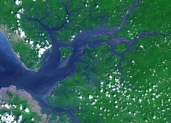
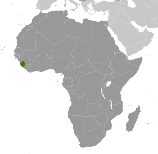
Western Africa, bordering the North Atlantic Ocean, between Guinea and Liberia
Geographic coordinates
8 30 N, 11 30 W
Map references
Africa
Area - comparative
slightly smaller than South Carolina
Land boundaries
total: 1,093 km
border countries (2): Guinea 794 km, Liberia 299 km
Coastline
402 km
Maritime claims
territorial sea: 12 nm
contiguous zone: 24 nm
exclusive economic zone: 200 nm
continental shelf: 200 nm
Climate
tropical; hot, humid; summer rainy season (May to December); winter dry season (December to April)
Terrain
coastal belt of mangrove swamps, wooded hill country, upland plateau, mountains in east
Elevation
highest point: Loma Mansa (Bintimani) 1,948 m
lowest point: Atlantic Ocean 0 m
mean elevation: 279 m
Natural resources
diamonds, titanium ore, bauxite, iron ore, gold, chromite
Land use
agricultural land: 56.2% (2018 est.)
arable land: 23.4% (2018 est.)
permanent crops: 2.3% (2018 est.)
permanent pasture: 30.5% (2018 est.)
forest: 37.5% (2018 est.)
other: 6.3% (2018 est.)
Irrigated land
300 sq km (2012)
Major watersheds (area sq km)
Atlantic Ocean drainage: Niger (2,261,741 sq km)
Population distribution
population clusters are found in the lower elevations of the south and west; the northern third of the country is less populated as shown on this population distribution map
Natural hazards
dry, sand-laden harmattan winds blow from the Sahara (December to February); sandstorms, dust storms
Geography - note
rainfall along the coast can reach 495 cm (195 inches) a year, making it one of the wettest places along coastal, western Africa
People and Society
Nationality
noun: Sierra Leonean(s)
adjective: Sierra Leonean
Ethnic groups
Temne 35.4%, Mende 30.8%, Limba 8.8%, Kono 4.3%, Korankoh 4%, Fullah 3.8%, Mandingo 2.8%, Loko 2%, Sherbro 1.9%, Creole 1.2% (descendants of freed Jamaican slaves who were settled in the Freetown area in the late-18th century; also known as Krio), other 5% (2019 est.)
Languages
English (official, regular use limited to literate minority), Mende (principal vernacular in the south), Temne (principal vernacular in the north), Krio (English-based Creole, spoken by the descendants of freed Jamaican slaves who were settled in the Freetown area, a lingua franca and a first language for 10% of the population but understood by 95%)
Religions
Muslim 77.1%, Christian 22.9% (2019 est.)
Demographic profile
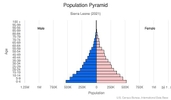
Sierra Leone’s youthful and growing population is driven by its high total fertility rate (TFR) of almost 5 children per woman, which has declined little over the last two decades. Its elevated TFR is sustained by the continued desire for large families, the low level of contraceptive use, and the early start of childbearing. Despite its high TFR, Sierra Leone’s population growth is somewhat tempered by high infant, child, and maternal mortality rates that are among the world’s highest and are a result of poverty, a lack of potable water and sanitation, poor nutrition, limited access to quality health care services, and the prevalence of female genital cutting.
Sierra Leone’s large youth cohort – about 60% of the population is under the age of 25 – continues to struggle with high levels of unemployment, which was one of the major causes of the country’s 1991-2002 civil war and remains a threat to stability today. Its estimated 60% youth unemployment rate is attributed to high levels of illiteracy and unskilled labor, a lack of private sector jobs, and low pay.
Sierra Leone has been a source of and destination for refugees. Sierra Leone’s civil war internally displaced as many as 2 million people, or almost half the population, and forced almost another half million to seek refuge in neighboring countries (370,000 Sierra Leoneans fled to Guinea and 120,000 to Liberia). The UNHCR has helped almost 180,000 Sierra Leoneans to return home, while more than 90,000 others have repatriated on their own. Of the more than 65,000 Liberians who took refuge in Sierra Leone during their country’s civil war (1989-2003), about 50,000 have been voluntarily repatriated by the UNHCR and others have returned home independently. As of 2015, less than 1,000 Liberians still reside in Sierra Leone.
Age structure
0-14 years: 41.38% (male 1,369,942/female 1,371,537)
15-24 years: 18.83% (male 610,396/female 636,880)
25-54 years: 32.21% (male 1,020,741/female 1,112,946)
55-64 years: 3.89% (male 121,733/female 135,664)
65 years and over: 3.7% (male 100,712/female 144,382) (2020 est.)

Dependency ratios
total dependency ratio: 76.3
youth dependency ratio: 71.1
elderly dependency ratio: 5.2
potential support ratio: 19.4 (2020 est.)
Median age
total: 19.1 years
male: 18.5 years
female: 19.7 years (2020 est.)
Population distribution
population clusters are found in the lower elevations of the south and west; the northern third of the country is less populated as shown on this population distribution map
Urbanization
urban population: 43.4% of total population (2021)
rate of urbanization: 3.02% annual rate of change (2020-25 est.)
Major urban areas - population
1.236 million FREETOWN (capital) (2021)
Sex ratio
at birth: 1.03 male(s)/female
0-14 years: 1 male(s)/female
15-24 years: 0.96 male(s)/female
25-54 years: 0.92 male(s)/female
55-64 years: 0.9 male(s)/female
65 years and over: 0.7 male(s)/female
total population: 0.95 male(s)/female (2020 est.)
Mother's mean age at first birth
19.6 years (2019 est.)
note: median age at first birth among women 20-49
Maternal mortality ratio
1,120 deaths/100,000 live births (2017 est.)
country comparison to the world: 3Infant mortality rate
total: 65.34 deaths/1,000 live births
male: 73.97 deaths/1,000 live births
female: 56.45 deaths/1,000 live births (2021 est.)
Life expectancy at birth
total population: 60.19 years
male: 57.48 years
female: 62.97 years (2021 est.)
Contraceptive prevalence rate
21.2% (2019)
Drinking water source
improved: urban: 89.5% of population
rural: 55.7% of population
total: 69.8% of population
unimproved: urban: 10.5% of population
rural: 44.3% of population
total: 30.2% of population (2017 est.)
Current Health Expenditure
16.1% (2018)
Physicians density
0.03 physicians/1,000 population (2011)
Sanitation facility access
improved: urban: 74.3% of population
rural: 31.9% of population
total: 49.6% of population
unimproved: urban: 25.7% of population
rural: 68.1% of population
total: 50.4% of population (2017 est.)
Major infectious diseases
degree of risk: very high (2020)
food or waterborne diseases: bacterial and protozoal diarrhea, hepatitis A, and typhoid fever
vectorborne diseases: malaria and dengue fever
water contact diseases: schistosomiasis
animal contact diseases: rabies
aerosolized dust or soil contact diseases: Lassa fever
Literacy
definition: age 15 and over can read and write English, Mende, Temne, or Arabic
total population: 43.2%
male: 51.6%
female: 39.8% (2018)
Unemployment, youth ages 15-24
total: 9.4%
male: 14.8%
female: 6.1% (2014 est.)
Environment
Environment - current issues
rapid population growth pressuring the environment; overharvesting of timber, expansion of cattle grazing, and slash-and-burn agriculture have resulted in deforestation, soil exhaustion, and flooding; loss of biodiversity; air pollution; water pollution; overfishing
Environment - international agreements
party to: Biodiversity, Climate Change, Climate Change-Kyoto Protocol, Climate Change-Paris Agreement, Comprehensive Nuclear Test Ban, Desertification, Endangered Species, Hazardous Wastes, Law of the Sea, Marine Dumping-London Convention, Marine Dumping-London Protocol, Marine Life Conservation, Nuclear Test Ban, Ozone Layer Protection, Ship Pollution, Wetlands
signed, but not ratified: Environmental Modification
Air pollutants
particulate matter emissions: 20.63 micrograms per cubic meter (2016 est.)
carbon dioxide emissions: 1.09 megatons (2016 est.)
methane emissions: 3.16 megatons (2020 est.)
Climate
tropical; hot, humid; summer rainy season (May to December); winter dry season (December to April)
Land use
agricultural land: 56.2% (2018 est.)
arable land: 23.4% (2018 est.)
permanent crops: 2.3% (2018 est.)
permanent pasture: 30.5% (2018 est.)
forest: 37.5% (2018 est.)
other: 6.3% (2018 est.)
Urbanization
urban population: 43.4% of total population (2021)
rate of urbanization: 3.02% annual rate of change (2020-25 est.)
Revenue from forest resources
forest revenues: 6.92% of GDP (2018 est.)
country comparison to the world: 8Major infectious diseases
degree of risk: very high (2020)
food or waterborne diseases: bacterial and protozoal diarrhea, hepatitis A, and typhoid fever
vectorborne diseases: malaria and dengue fever
water contact diseases: schistosomiasis
animal contact diseases: rabies
aerosolized dust or soil contact diseases: Lassa fever
Food insecurity
severe localized food insecurity: due to high food prices - about 1.76 million people are estimated to be severely food insecure during the June−August 2021 period on account of high food prices and low purchasing power, resulting in acute constraints on households’ access to food; the main drivers of the food insecurity are the effects of adverse weather events (flooding), Fall Armyworm attacks on maize in some localized areas, high inflation rate, weakening local currency and the effects of the COVID‑19 pandemic restrictions (2021)
Waste and recycling
municipal solid waste generated annually: 610,222 tons (2004 est.)
Major watersheds (area sq km)
Atlantic Ocean drainage: Niger (2,261,741 sq km)
Total water withdrawal
municipal: 111 million cubic meters (2017 est.)
industrial: 55.5 million cubic meters (2017 est.)
agricultural: 45.7 million cubic meters (2017 est.)
Total renewable water resources
160 billion cubic meters (2017 est.)
Government
Country name
conventional long form: Republic of Sierra Leone
conventional short form: Sierra Leone
local long form: Republic of Sierra Leone
local short form: Sierra Leone
etymology: the Portuguese explorer Pedro de SINTRA named the country "Serra Leoa" (Lion Mountains) for the impressive mountains he saw while sailing the West African coast in 1462
Government type
presidential republic
Capital
name: Freetown
geographic coordinates: 8 29 N, 13 14 W
time difference: UTC 0 (5 hours ahead of Washington, DC, during Standard Time)
etymology: name derived from the fact that the original settlement served as a haven for free-born and freed African Americans, as well as for liberated Africans rescued from slave ships
Administrative divisions
4 provinces and 1 area*; Eastern, Northern, North Western, Southern, Western*
Independence
27 April 1961 (from the UK)
National holiday
Independence Day, 27 April (1961)
Constitution
history: several previous; latest effective 1 October 1991
amendments: proposed by Parliament; passage of amendments requires at least two-thirds majority vote of Parliament in two successive readings and assent of the president of the republic; passage of amendments affecting fundamental rights and freedoms and many other constitutional sections also requires approval in a referendum with participation of at least one half of qualified voters and at least two thirds of votes cast; amended several times, last in 2016
Legal system
mixed legal system of English common law and customary law
International law organization participation
has not submitted an ICJ jurisdiction declaration; accepts ICCt jurisdiction
Citizenship
citizenship by birth: no
citizenship by descent only: at least one parent or grandparent must be a citizen of Sierra Leone
dual citizenship recognized: yes
residency requirement for naturalization: 5 years
Suffrage
18 years of age; universal
Executive branch
chief of state: President Julius Maada BIO (since 4 April 2018); Vice President Mohamed Juldeh JALLOH (since 4 April 2018) ; note - the president is both chief of state, head of government, and minister of defense
head of government: President Julius Maada BIO (since 4 April 2018); Vice President Mohamed Juldeh JALLOH (since 4 April 2018)
cabinet: Ministers of State appointed by the president, approved by Parliament; the cabinet is responsible to the president
elections/appointments: president directly elected by absolute majority popular vote in 2 rounds if needed for a 5-year term (eligible for a second term); election last held on 4 April 2018 (next to be in 2023)
election results: Julius Maada BIO elected president in second round; percent of vote - Julius Maada BIO (SLPP) 51.8%, Samura KAMARA (APC) 48.2%
Legislative branch
description: unicameral Parliament (146 seats; 132 members directly elected in single-seat constituencies by simple majority vote and 14 seats filled in separate elections by non-partisan members of Parliament called "paramount chiefs;" members serve 5-year terms)
elections: last held on 7 March 2018 (next to be held in March 2023)
election results: percent of vote by party - n/a; seats by party - APC 68, SLPP 49, C4C 8, other 7; composition - men 131, women 15, percent of women 10.3%
Judicial branch
highest courts: Superior Court of Judicature (consists of the Supreme Court - at the apex - with the chief justice and 4 other judges, the Court of Appeal with the chief justice and 7 other judges, and the High Court of Justice with the chief justice and 9 other judges); note – the Judicature has jurisdiction in all civil, criminal, and constitutional matters
judge selection and term of office: Supreme Court chief justice and other judges of the Judicature appointed by the president on the advice of the Judicial and Legal Service Commission, a 7-member independent body of judges, presidential appointees, and the Commission chairman, and are subject to approval by Parliament; all Judicature judges serve until retirement at age 65
subordinate courts: magistrates' courts; District Appeals Court; local courts
Political parties and leaders
All People's Congress or APC [Ernest Bai KOROMA]
Coalition for Change or C4C [Tamba R. SANDY]
National Grand Coalition or NGC [Dr. Dennis BRIGHT]
Sierra Leone People's Party or SLPP [Dr. Prince HARDING]
numerous other parties
International organization participation
ACP, AfDB, AU, C, ECOWAS, EITI (compliant country), FAO, G-77, IAEA, IBRD, ICAO, ICCt, ICRM, IDA, IDB, IFAD, IFC, IFRCS, IHO (pending member), ILO, IMF, IMO, Interpol, IOC, IOM, IPU, ISO (correspondent), ITU, ITUC (NGOs), MIGA, MINUSMA, NAM, OIC, OPCW, UN, UNAMID, UNCTAD, UNESCO, UNIDO, UNIFIL, UNISFA, UNWTO, UPU, WCO, WFTU (NGOs), WHO, WIPO, WMO, WTO
Diplomatic representation in the US
chief of mission: Ambassador Sidique Abou-Bakarr WAI (since 8 April 2019)
chancery: 1701 19th Street NW, Washington, DC 20009-1605
telephone: [1] (202) 939-9261
FAX: [1] (202) 483-1793
email address and website:
info@embassyofsierraleone.net
https://embassyofsierraleone.net/
Diplomatic representation from the US
chief of mission: Ambassador David REIMER (since 24 March 2021)
embassy: Southridge-Hill Station, Freetown
mailing address: 2160 Freetown Place, Washington DC 20521-2160
telephone: [232] 99 105 000
email address and website:
consularfreetown@state.gov
https://sl.usembassy.gov/
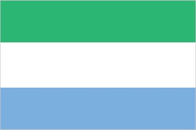
Flag description
three equal horizontal bands of light green (top), white, and light blue; green symbolizes agriculture, mountains, and natural resources, white represents unity and justice, and blue the sea and the natural harbor in Freetown
National symbol(s)
lion; national colors: green, white, blue
National anthem
name: High We Exalt Thee, Realm of the Free
lyrics/music: Clifford Nelson FYLE/John Joseph AKA
note: adopted 1961
Economy
Economic overview
Sierra Leone is extremely poor and nearly half of the working-age population engages in subsistence agriculture. The country possesses substantial mineral, agricultural, and fishery resources, but it is still recovering from a civil war that destroyed most institutions before ending in the early 2000s.
In recent years, economic growth has been driven by mining - particularly iron ore. The country’s principal exports are iron ore, diamonds, and rutile, and the economy is vulnerable to fluctuations in international prices. Until 2014, the government had relied on external assistance to support its budget, but it was gradually becoming more independent. The Ebola outbreak of 2014 and 2015, combined with falling global commodities prices, caused a significant contraction of economic activity in all areas. While the World Health Organization declared an end to the Ebola outbreak in Sierra Leone in November 2015, low commodity prices in 2015-2016 contributed to the country’s biggest fiscal shortfall since 2001. In 2017, increased iron ore exports, together with the end of the Ebola epidemic, supported a resumption of economic growth.
Continued economic growth will depend on rising commodities prices and increased efforts to diversify the sources of growth. Non-mining activities will remain constrained by inadequate infrastructure, such as power and roads, even though power sector projects may provide some additional electricity capacity in the near term. Pervasive corruption and undeveloped human capital will continue to deter foreign investors. Sustained international donor support in the near future will partially offset these fiscal constraints.
Real GDP (purchasing power parity)
$13.15 billion note: data are in 2017 dollars (2020 est.)
$13.44 billion note: data are in 2017 dollars (2019 est.)
$12.72 billion note: data are in 2017 dollars (2018 est.)
note: data are in 2010 dollars
Real GDP growth rate
3.7% (2017 est.)
6.3% (2016 est.)
-20.5% (2015 est.)
Real GDP per capita
$1,600 note: data are in 2017 dollars (2020 est.)
$1,700 note: data are in 2017 dollars (2019 est.)
$1,700 note: data are in 2017 dollars (2018 est.)
note: data are in 2017 dollars
GDP (official exchange rate)
$4.132 billion (2020 est.)
Inflation rate (consumer prices)
14.8% (2019 est.)
16% (2018 est.)
18.2% (2017 est.)
GDP - composition, by sector of origin
agriculture: 60.7% (2017 est.)
industry: 6.5% (2017 est.)
services: 32.9% (2017 est.)
GDP - composition, by end use
household consumption: 97.9% (2017 est.)
government consumption: 12.1% (2017 est.)
investment in fixed capital: 18.1% (2017 est.)
investment in inventories: 0.4% (2017 est.)
exports of goods and services: 26.8% (2017 est.)
imports of goods and services: -55.3% (2017 est.)
Agricultural products
cassava, rice, vegetables, oil palm fruit, sweet potatoes, milk, citrus fruit, groundnuts, fruit, pulses nes
Industries
diamond mining; iron ore, rutile and bauxite mining; small-scale manufacturing (beverages, textiles, footwear)
Labor force - by occupation
agriculture: 61.1%
industry: 5.5%
services: 33.4% (2014 est.)
Population below poverty line
56.8% (2018 est.)
Gini Index coefficient - distribution of family income
35.7 (2018 est.)
62.9 (1989)
Household income or consumption by percentage share
lowest 10%: 2.6%
highest 10%: 33.6% (2003)
Budget
revenues: 562 million (2017 est.)
expenditures: 846.4 million (2017 est.)
Fiscal year
calendar year
Current account balance
-$407 million (2017 est.)
-$88 million (2016 est.)
Exports
$740 million note: data are in current year dollars (2019 est.)
$720 million note: data are in current year dollars (2018 est.)
Exports - partners
Belgium 26%, China 25%, Romania 9%, United Arab Emirates 6%, Germany 5%, Netherlands 5% (2019)
Exports - commodities
titanium, lumber, diamonds, aluminum, cocoa beans (2019)
Imports
$1.82 billion note: data are in current year dollars (2019 est.)
$2.072 billion (2018 est.)
$1.59 billion note: data are in current year dollars (2018 est.)
Imports - partners
China 27%, India 11%, United States 6%, Ghana 5%, Turkey 5% (2019)
Imports - commodities
rice, plastics, packaged medicines, sauces/seasonings, cars (2019)
Reserves of foreign exchange and gold
$478 million (31 December 2017 est.)
$497.2 million (31 December 2016 est.)
Debt - external
$1.615 billion (31 December 2017 est.)
$1.503 billion (31 December 2016 est.)
Exchange rates
leones (SLL) per US dollar -
7,396.3 (2017 est.)
6,289.9 (2016 est.)
6,289.9 (2015 est.)
5,080.8 (2014 est.)
4,524.2 (2013 est.)
Unemployment, youth ages 15-24
total: 9.4%
male: 14.8%
female: 6.1% (2014 est.)
Energy
Electricity access
electrification - total population: 26% (2019)
electrification - urban areas: 52% (2019)
electrification - rural areas: 6% (2019)
Electricity - installed generating capacity
113,300 kW (2016 est.)
country comparison to the world: 179Electricity - from fossil fuels
23% of total installed capacity (2016 est.)
country comparison to the world: 194Electricity - from nuclear fuels
0% of total installed capacity (2017 est.)
country comparison to the world: 182Electricity - from hydroelectric plants
51% of total installed capacity (2017 est.)
country comparison to the world: 38Electricity - from other renewable sources
26% of total installed capacity (2017 est.)
country comparison to the world: 26Refined petroleum products - consumption
6,500 bbl/day (2016 est.)
country comparison to the world: 169Communications
Telephones - fixed lines
total subscriptions: 189 (2020)
subscriptions per 100 inhabitants: 0 (2020 est.)
Telephones - mobile cellular
total subscriptions: 6,884,201 (2020)
subscriptions per 100 inhabitants: 86.3 (2020 est.)
Telecommunication systems
general assessment: telecom sector is recovering from the decades of war, yet still constrained by inadequate power and pervasive corruption; recently installed terrestrial fiber backbone infrastructure; telephone service improving with the rapid growth of mobile sector; operators increased investment to provide national coverage; LTE available in some parts of the country; construction of 600 km ECOWAS Wide Area Network completed; fiber link to Guinea completed; importer of broadcasting equipment from China (2020)
domestic: fixed-line less than 1 per 100 and mobile-cellular 86 per 100 (2019)
international: country code - 232; landing point for the ACE submarine cable linking to South Africa, over 20 western African countries and Europe; satellite earth station - 1 Intelsat (Atlantic Ocean) (2019)
note: the COVID-19 pandemic continues to have a significant impact on production and supply chains globally; since 2020, some aspects of the telecom sector have experienced downturn, particularly in mobile device production; many network operators delayed upgrades to infrastructure; progress towards 5G implementation was postponed or slowed in some countries; consumer spending on telecom services and devices was affected by large-scale job losses and the consequent restriction on disposable incomes; the crucial nature of telecom services as a tool for work and school from home became evident, and received some support from governments
Broadcast media
1 government-owned TV station; 3 private TV stations; a pay-TV service began operations in late 2007; 1 government-owned national radio station; about two-dozen private radio stations primarily clustered in major cities; transmissions of several international broadcasters are available
(2019)Internet users
total: 2.39 million (2021 est.)
percent of population: 9% (2019 est.)
Transportation
National air transport system
annual passenger traffic on registered air carriers: 50,193 (2015)
annual freight traffic on registered air carriers: 0 mt-km (2015)
Airports - with paved runways
total: 1
over 3,047 m: 1 (2019)
Airports - with unpaved runways
total: 7
914 to 1,523 m: 7
Heliports
2 (2013)
Roadways
total: 11,700 km (2015)
paved: 1,051 km (2015)
unpaved: 10,650 km (2015)
urban: 3,000 km (2015)
non-urban: 8,700 km (2015)
Merchant marine
total: 591
by type: bulk carrier 30, container ship 9, general cargo 319, oil tanker 108, other 125 (2021)
Ports and terminals
major seaport(s): Freetown, Pepel, Sherbro Islands
Military and Security
Military and security forces
Republic of Sierra Leone Armed Forces (RSLAF): operates under a Joint Force Command with Land Forces, Maritime Forces, and an Air Wing (2021)
Military expenditures
0.5% of GDP (2020 est.)
0.7% of GDP (2019)
0.7% of GDP (2018)
0.4% of GDP (2017)
0.3% of GDP (2016)
Military and security service personnel strengths
the Republic of Sierra Leone Armed Forces (RSLAF) have approximately 9,000 personnel, mostly ground forces (2021)
Military equipment inventories and acquisitions
the RSLAF's small inventory includes a mix of Soviet-origin and other older foreign-supplied equipment; since 2010, it has received limited quantities of material (mostly donations of second-hand equipment) from China and South Africa (2020)
Military service age and obligation
18-29 for voluntary military service; women are eligible to serve; no conscription (2019)
Military - note
after the end of the civil war in 2002, the military was reduced in size and restructured with British military assistance; the RSLAF’s origins lie in the Sierra Leone Battalion of the Royal West African Frontier Force (RWAFF), a multi-regiment force formed by the British colonial office in 1900 to garrison the West African colonies of Gold Coast (Ghana), Nigeria (Lagos and the protectorates of Northern and Southern Nigeria), Sierra Leone, and Gambia; the RWAFF fought in both World Wars
Transnational Issues
Disputes - international
Sierra Leone opposes Guinean troops' continued occupation of Yenga, a small village on the Makona River that serves as a border with Guinea; Guinea's forces came to Yenga in the mid-1990s to help the Sierra Leonean military to suppress rebels and to secure their common border but have remained there even after both countries signed a 2005 agreement acknowledging that Yenga belonged to Sierra Leone; in 2012, the two sides signed a declaration to demilitarize the area
Refugees and internally displaced persons
IDPs: 5,500 (displacement caused by post-electoral violence in 2018 and clashes in the Pujehun region in 2019) (2020)