


Introduction
Background
Vanuatu was first settled around 2000 B.C. by Austronesian speakers from Solomon Islands. By around 1000, localized chieftain systems began to develop on the islands. In the mid-1400s, the Kuwae Volcano erupted, causing frequent conflict and internal strife amid declining food availability, especially on Efate Island. Around 1600, Chief ROI MATA united Efate under his rule. In 1606, Portuguese explorer Pedro Fernandes de QUEIROS was the first European to see the Banks Islands and Espiritu Santo, setting up a short-lived settlement on the latter. The next European explorers arrived in the 1760s, and in 1774, British navigator James COOK named the islands the New Hebrides. The islands were frequented by whalers in the 1800s and interest in harvesting the islands’ sandalwood trees caused conflict between Europeans and local Ni-Vanuatu. Catholic and Protestant missionaries arrived in the 1840s but faced difficulties converting the locals. In the 1860s, European planters in Australia, Fiji, New Caledonia, and Samoa needed labor and kidnapped almost half the adult males of the islands and forced them to work as indentured servants.
With growing and overlapping interests in the islands, France and the UK agreed that the New Hebrides would be neutral in 1878 and established a joint naval commission in 1887. In 1906, the two countries created the British-French Condominium to jointly administer the islands and they established separate laws, police forces, currencies, and education and health systems. The condominium arrangement was dysfunctional and the UK used France’s defeat to Germany in World War II to assert greater control over the islands. As Japan pushed into Melanesia, the US stationed up to 50,000 soldiers in Vanuatu to prevent further advances. In 1945, US troops withdrew and sold their equipment, leading to the rise of political and religious cargo cults, such as the John Frum movement.
The France-UK condominium was reestablished after World War II. The UK was interested in moving the condominium toward independence in the 1960s but France was hesitant and political parties agitating independence began to form, largely divided along linguistic lines. France eventually relented and elections were held in 1974 with independence granted in 1980 as Vanuatu under English-speaking Prime Minister Walter LINI. At independence, the Nagriamel Movement, with support from French-speaking landowners, declared Espiritu Santo independent, but the short-lived state was dissolved 12 weeks later. Linguistic divisions have lessened over time but highly fractious political parties have led to weak coalition governments that require support from both Anglophone and Francophone parties. Since 2008, prime ministers have been ousted through no-confidence motions or temporary procedural issues 10 times.
Visit the Definitions and Notes page to view a description of each topic.
Geography
Location
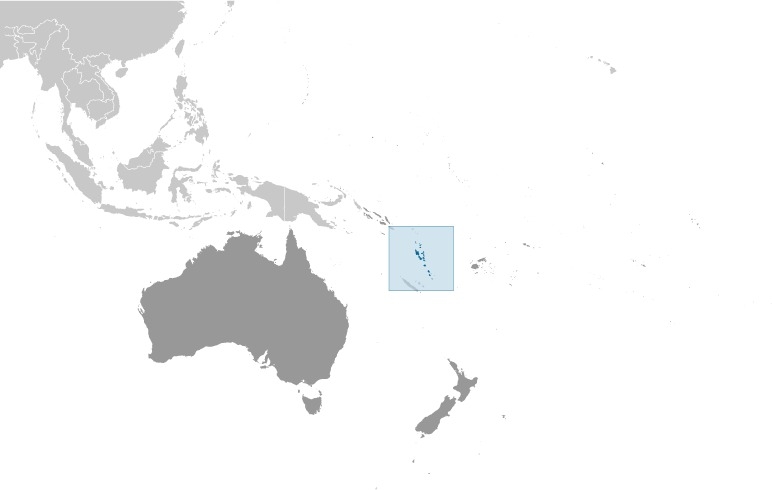
Oceania, group of islands in the South Pacific Ocean, about three-quarters of the way from Hawaii to Australia
Geographic coordinates
16 00 S, 167 00 E
Map references
Oceania
Area
total: 12,189 sq km
land: 12,189 sq km
water: 0 sq km
note: includes more than 80 islands, about 65 of which are inhabited
Area - comparative
slightly larger than Connecticut
Land boundaries
total: 0 km
Coastline
2,528 km
Maritime claims
territorial sea: 12 nm
contiguous zone: 24 nm
exclusive economic zone: 200 nm
continental shelf: 200 nm or to the edge of the continental margin
measured from claimed archipelagic baselines
Climate
tropical; moderated by southeast trade winds from May to October; moderate rainfall from November to April; may be affected by cyclones from December to April
Terrain
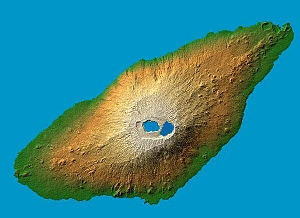
mostly mountainous islands of volcanic origin; narrow coastal plains
Elevation
highest point: Tabwemasana 1,877 m
lowest point: Pacific Ocean 0 m
Natural resources
manganese, hardwood forests, fish
Land use
agricultural land: 15.3% (2018 est.)
arable land: 1.6% (2018 est.)
permanent crops: 10.3% (2018 est.)
permanent pasture: 3.4% (2018 est.)
forest: 36.1% (2018 est.)
other: 48.6% (2018 est.)
Irrigated land
0 sq km (2012)
Population distribution
three-quarters of the population lives in rural areas; the urban populace lives primarily in two cities, Port-Vila and Lugenville; three largest islands - Espiritu Santo, Malakula, and Efate - accomodate over half of the populace
Natural hazards
tropical cyclones (January to April); volcanic eruption on Aoba (Ambae) island began on 27 November 2005, volcanism also causes minor earthquakes; tsunamis
volcanism: significant volcanic activity with multiple eruptions in recent years; Yasur (361 m), one of the world's most active volcanoes, has experienced continuous activity in recent centuries; other historically active volcanoes include Aoba, Ambrym, Epi, Gaua, Kuwae, Lopevi, Suretamatai, and Traitor's Head
Geography - note
a Y-shaped chain of four main islands and 80 smaller islands; several of the islands have active volcanoes and there are several underwater volcanoes as well
People and Society
Nationality
noun: Ni-Vanuatu (singular and plural)
adjective: Ni-Vanuatu
Ethnic groups
Melanesian 99.2%, non-Melanesian 0.8% (2016 est.)
Languages
local languages (more than 100) 63.2%, Bislama (official; creole) 33.7%, English (official) 2%, French (official) 0.6%, other 0.5% (2009 est.)
Religions
Protestant 70% (includes Presbyterian 27.9%, Anglican 15.1%, Seventh Day Adventist 12.5%, Assemblies of God 4.7%, Church of Christ 4.5%, Neil Thomas Ministry 3.1%, and Apostolic 2.2%), Roman Catholic 12.4%, customary beliefs 3.7% (including Jon Frum cargo cult), other 12.6%, none 1.1%, unspecified 0.2% (2009 est.)
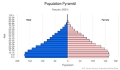
Age structure
0-14 years: 33.65% (male 51,267/female 49,111)
15-24 years: 19.99% (male 29,594/female 30,050)
25-54 years: 36.09% (male 52,529/female 55,130)
55-64 years: 5.89% (male 8,666/female 8,904)
65 years and over: 4.39% (male 6,518/female 6,564) (2020 est.)

Dependency ratios
total dependency ratio: 72.5
youth dependency ratio: 66.2
elderly dependency ratio: 12.3
potential support ratio: 8.1 (2020 est.)
Median age
total: 23 years
male: 22.6 years
female: 23.5 years (2020 est.)
Population distribution
three-quarters of the population lives in rural areas; the urban populace lives primarily in two cities, Port-Vila and Lugenville; three largest islands - Espiritu Santo, Malakula, and Efate - accomodate over half of the populace
Urbanization
urban population: 25.7% of total population (2021)
rate of urbanization: 2.55% annual rate of change (2020-25 est.)
Major urban areas - population
53,000 PORT-VILA (capital) (2018)
Sex ratio
at birth: 1.05 male(s)/female
0-14 years: 1.04 male(s)/female
15-24 years: 0.98 male(s)/female
25-54 years: 0.95 male(s)/female
55-64 years: 0.97 male(s)/female
65 years and over: 0.99 male(s)/female
total population: 0.99 male(s)/female (2020 est.)
Maternal mortality ratio
72 deaths/100,000 live births (2017 est.)
country comparison to the world: 82Infant mortality rate
total: 14.69 deaths/1,000 live births
male: 16.14 deaths/1,000 live births
female: 13.17 deaths/1,000 live births (2021 est.)
Life expectancy at birth
total population: 74.87 years
male: 73.18 years
female: 76.66 years (2021 est.)
Contraceptive prevalence rate
49% (2013)
Drinking water source
improved: urban: 100% of population
rural: 89.7% of population
total: 92.3% of population
unimproved: urban: 0% of population
rural: 10.3% of population
total: 7.7% of population (2017 est.)
Current Health Expenditure
3.4% (2018)
Physicians density
0.17 physicians/1,000 population (2016)
Sanitation facility access
improved: urban: 91.6% of population
rural: 60.9% of population
total: 68.6% of population
unimproved: urban: 8.4% of population
rural: 39.1% of population
total: 31.4% of population (2017 est.)
Major infectious diseases
degree of risk: high (2020)
food or waterborne diseases: bacterial diarrhea
vectorborne diseases: malaria
Literacy
definition: age 15 and over can read and write
total population: 87.5%
male: 88.3%
female: 86.7% (2018)
Unemployment, youth ages 15-24
total: 18%
male: 16.1%
female: 20.1% (2019 est.)
Environment
Environment - current issues
population growth; water pollution, most of the population does not have access to a reliable supply of potable water; inadequate sanitation; deforestation
Environment - international agreements
party to: Antarctic-Marine Living Resources, Biodiversity, Climate Change, Climate Change-Kyoto Protocol, Climate Change-Paris Agreement, Comprehensive Nuclear Test Ban, Desertification, Endangered Species, Hazardous Wastes, Law of the Sea, Marine Dumping-London Convention, Marine Dumping-London Protocol, Ozone Layer Protection, Ship Pollution, Wetlands
signed, but not ratified: none of the selected agreements
Air pollutants
particulate matter emissions: 10.31 micrograms per cubic meter (2016 est.)
carbon dioxide emissions: 0.15 megatons (2016 est.)
methane emissions: 0.5 megatons (2020 est.)
Climate
tropical; moderated by southeast trade winds from May to October; moderate rainfall from November to April; may be affected by cyclones from December to April
Land use
agricultural land: 15.3% (2018 est.)
arable land: 1.6% (2018 est.)
permanent crops: 10.3% (2018 est.)
permanent pasture: 3.4% (2018 est.)
forest: 36.1% (2018 est.)
other: 48.6% (2018 est.)
Urbanization
urban population: 25.7% of total population (2021)
rate of urbanization: 2.55% annual rate of change (2020-25 est.)
Revenue from forest resources
forest revenues: 0.54% of GDP (2018 est.)
country comparison to the world: 64Major infectious diseases
degree of risk: high (2020)
food or waterborne diseases: bacterial diarrhea
vectorborne diseases: malaria
Waste and recycling
municipal solid waste generated annually: 70,225 tons (2012 est.)
municipal solid waste recycled annually: 25,983 tons (2013 est.)
percent of municipal solid waste recycled: 37% (2013 est.)
Total renewable water resources
10 billion cubic meters (2017 est.)
Government
Country name
conventional long form: Republic of Vanuatu
conventional short form: Vanuatu
local long form: Ripablik blong Vanuatu
local short form: Vanuatu
former: New Hebrides
etymology: derived from the words "vanua" (home or land) and "tu" (stand) that occur in several of the Austonesian languages spoken on the islands and which provide a meaning of "the land remains" but which also convey a sense of "independence" or "our land"
Government type
parliamentary republic
Capital
name: Port-Vila (on Efate)
geographic coordinates: 17 44 S, 168 19 E
time difference: UTC+11 (16 hours ahead of Washington, DC, during Standard Time)
etymology: there are two possibilities for the origin of the name: early European settlers were Portuguese and "vila" means "village or town" in Portuguese, hence "Port-Vila" would mean "Port Town"; alternatively, the site of the capital is referred to as "Efil" or "Ifira" in native languages, "Vila" is a likely corruption of these names
Administrative divisions
6 provinces; Malampa, Penama, Sanma, Shefa, Tafea, Torba
Independence
30 July 1980 (from France and the UK)
National holiday
Independence Day, 30 July (1980)
Constitution
history: draft completed August 1979, finalized by constitution conference 19 September 1979, ratified by French and British Governments 23 October 1979, effective 30 July 1980 at independence
amendments: proposed by the prime minister or by the Parliament membership; passage requires at least two-thirds majority vote by Parliament in special session with at least three fourths of the membership; passage of amendments affecting the national and official languages, or the electoral and parliamentary system also requires approval in a referendum; amended several times, last in 2013
Legal system
mixed legal system of English common law, French law, and customary law
International law organization participation
has not submitted an ICJ jurisdiction declaration; accepts ICCt jurisdiction
Citizenship
citizenship by birth: no
citizenship by descent only: both parents must be citizens of Vanuatu; in the case of only one parent, it must be the father who is a citizen
dual citizenship recognized: no
residency requirement for naturalization: 10 years
Suffrage
18 years of age; universal
Executive branch
chief of state: President Tallis Obed MOSES (since 6 July 2017)
head of government: Prime Minister Bob LOUGHMAN (since 20 April 2020)
cabinet: Council of Ministers appointed by the prime minister, responsible to Parliament
elections/appointments: president indirectly elected by an electoral college consisting of Parliament and presidents of the 6 provinces; Vanuatu president serves a 5-year term; election last held on 17 June 2017 (next to be held in 2022); following legislative elections, the leader of the majority party or majority coalition usually elected prime minister by Parliament from among its members; election for prime minister last held on 20 April 2020 (next to be held following general elections in 2024)
election results: Bob LOUGHMAN elected prime minister on 20 April 2020; Bob LOUGHMAN 31 votes, Ralph REGENVANU 21 votes
Legislative branch
description: unicameral Parliament (52 seats; members directly elected in 8 single-seat and 9 multi-seat constituencies by single non-transferable vote to serve 4-year terms (candidates in multi-seat constituencies can be elected with only 4% of the vote)
elections: last held on 19–20 March 2020 (next to be held in 2024)
election results: percent of vote by party - NA; seats by party - GJP 9, RMC 7, VP 7, LPV 5, UMP 5, NUP 4, other 15; composition - men 52, women 0; percent of women 0%; note - political party associations are fluid
note: the National Council of Chiefs advises on matters of culture and language
Judicial branch
highest courts: Court of Appeal (consists of 2 or more judges of the Supreme Court designated by the chief justice); Supreme Court (consists of the chief justice and 6 puisne judges - 3 local and 3 expatriate)
judge selection and term of office: Supreme Court chief justice appointed by the president after consultation with the prime minister and the leader of the opposition; other judges appointed by the president on the advice of the Judicial Service Commission, a 4-member advisory body; judges serve until the age of retirement
subordinate courts: Magistrates Courts; Island Courts
Political parties and leaders
Greens Confederation or GC [Moana CARCASSES Kalosil]
Iauko Group or IG [Tony NARI]
Land and Justice Party (Graon mo Jastis Pati) or GJP [Ralph REGENVANU]
Melanesian Progressive Party or MPP [Barak SOPE]
Nagriamel movement or NAG [Frankie STEVENS]
Natatok Indigenous People's Democratic Party or (NATATOK) or NIPDP [Alfred Roland CARLOT]
National United Party or NUP [Ham LINI]
People's Progressive Party or PPP [Sato KILMAN]
People's Service Party or PSP [Don KEN]
Reunification of Movement for Change or RMC [Charlot SALWAI]
Rural Development Party or RDP [Jay NGWELE, spokesman]
Union of Moderate Parties or UMP [Serge VOHOR]
Vanua'aku Pati (Our Land Party) or VP [Edward NATAPEI]
Vanuatu Democratic Party [Maxime Carlot KORMAN]
Vanuatu First or Vanuatu [Russel NARI]
Vanuatu Liberal Movement or VLM [Gaetan PIKIOUNE]
Vanuatu Liberal Democratic Party or VLDP [Tapangararua WILLIE]
Vanuatu National Party or VNP [Issac HAMARILIU]
Vanuatu National Development Party or VNDP [Robert Bohn SIKOL]
Vanuatu Republican Party or VRP [Marcellino PIPITE]
International organization participation
ACP, ADB, AOSIS, C, FAO, G-77, IBRD, ICAO, ICRM, IDA, IFC, IFRCS, ILO, IMF, IMO, IMSO, IOC, IOM, ITU, ITUC (NGOs), MIGA, NAM, OAS (observer), OIF, OPCW, PIF, Sparteca, SPC, UN, UNCTAD, UNESCO, UNIDO, UNWTO, UPU, WCO, WFTU (NGOs), WHO, WIPO, WMO, WTO
Diplomatic representation in the US
chief of mission: none; the Vanuatu Permanent Mission to the UN serves as the embassy; it is headed by Odo TEVI (since 8 September 2017); address: 800 Second Avenue, Suite 400B, New York, NY 10017; telephone: [1] (212) 661-4303; FAX: [1] (212) 422-3427; email: vanunmis@aol.com
Diplomatic representation from the US
embassy: the US does not have an embassy in Vanuatu; the US Ambassador to Papua New Guinea is accredited to Vanuatu
Flag description
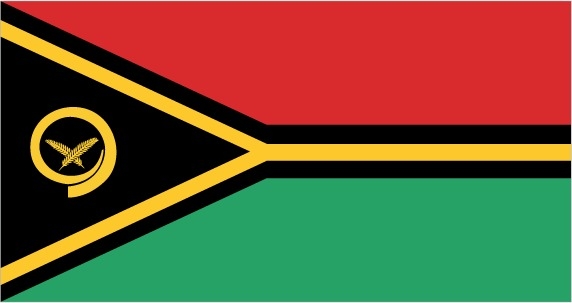
two equal horizontal bands of red (top) and green with a black isosceles triangle (based on the hoist side) all separated by a black-edged yellow stripe in the shape of a horizontal Y (the two points of the Y face the hoist side and enclose the triangle); centered in the triangle is a boar's tusk encircling two crossed namele fern fronds, all in yellow; red represents the blood of boars and men, as well as unity, green the richness of the islands, and black the ni-Vanuatu people; the yellow Y-shape - which reflects the pattern of the islands in the Pacific Ocean - symbolizes the light of the Gospel spreading through the islands; the boar's tusk is a symbol of prosperity frequently worn as a pendant on the islands; the fern fronds represent peace
note: one of several flags where a prominent component of the design reflects the shape of the country; other such flags are those of Bosnia and Herzegovina, Brazil, and Eritrea
National symbol(s)
boar's tusk with crossed fern fronds; national colors: red, black, green, yellow
National anthem
name: "Yumi, Yumi, Yumi" (We, We, We)
lyrics/music: Francois Vincent AYSSAV
note: adopted 1980; the anthem is written in Bislama, a Creole language that mixes Pidgin English and French
Economy
Economic overview
This South Pacific island economy is based primarily on small-scale agriculture, which provides a living for about two thirds of the population. Fishing, offshore financial services, and tourism, with more than 330,000 visitors in 2017, are other mainstays of the economy. Tourism has struggled after Efate, the most populous and most popular island for tourists, was damaged by Tropical Cyclone Pam in 2015. Ongoing infrastructure difficulties at Port Vila’s Bauerfield Airport have caused air travel disruptions, further hampering tourism numbers. Australia and New Zealand are the main source of tourists and foreign aid. A small light industry sector caters to the local market. Tax revenues come mainly from import duties. Mineral deposits are negligible; the country has no known petroleum deposits.
Economic development is hindered by dependence on relatively few commodity exports, vulnerability to natural disasters, and long distances from main markets and between constituent islands. In response to foreign concerns, the government has promised to tighten regulation of its offshore financial center.
Since 2002, the government has stepped up efforts to boost tourism through improved air connections, resort development, and cruise ship facilities. Agriculture, especially livestock farming, is a second target for growth.
Real GDP (purchasing power parity)
$850 million note: data are in 2017 dollars (2020 est.)
$930 million note: data are in 2017 dollars (2019 est.)
$910 million note: data are in 2017 dollars (2018 est.)
note: data are in 2017 dollars
Real GDP growth rate
4.2% (2017 est.)
3.5% (2016 est.)
0.2% (2015 est.)
Real GDP per capita
$2,800 note: data are in 2017 dollars (2020 est.)
$3,100 note: data are in 2017 dollars (2019 est.)
$3,100 note: data are in 2017 dollars (2018 est.)
note: data are in 2017 dollars
GDP (official exchange rate)
$870 million (2017 est.)
Inflation rate (consumer prices)
3.1% (2017 est.)
0.8% (2016 est.)
GDP - composition, by sector of origin
agriculture: 27.3% (2017 est.)
industry: 11.8% (2017 est.)
services: 60.8% (2017 est.)
GDP - composition, by end use
household consumption: 59.9% (2017 est.)
government consumption: 17.4% (2017 est.)
investment in fixed capital: 28.7% (2017 est.)
investment in inventories: 0% (2017 est.)
exports of goods and services: 42.5% (2017 est.)
imports of goods and services: -48.5% (2017 est.)
Agricultural products
coconuts, roots/tubers nes, bananas, vegetables, pork, fruit, milk, beef, groundnuts, cocoa
Industries
food and fish freezing, wood processing, meat canning
Labor force - by occupation
agriculture: 65%
industry: 5%
services: 30% (2000 est.)
Gini Index coefficient - distribution of family income
37.6 (2010 est.)
country comparison to the world: 78Household income or consumption by percentage share
lowest 10%: NA
highest 10%: NA
Budget
revenues: 236.7 million (2017 est.)
expenditures: 244.1 million (2017 est.)
Fiscal year
calendar year
Current account balance
-$13 million (2017 est.)
-$37 million (2016 est.)
Exports
$380 million note: data are in current year dollars (2019 est.)
$520 million note: data are in current year dollars (2018 est.)
Exports - partners
Japan 33%, Thailand 13%, Mauritania 13%, South Korea 11%, China 9%, Fiji 7% (2019)
Exports - commodities
fish and fish products, tug boats, perfume plants, mollusks, cocoa beans (2019)
Imports
$460 million note: data are in current year dollars (2019 est.)
$460 million note: data are in current year dollars (2018 est.)
Imports - partners
China 29%, Australia 18%, New Zealand 11%, Fiji 11%, Taiwan 5%, Thailand 5% (2019)
Imports - commodities
refined petroleum, fishing ships, delivery trucks, poultry meats, broadcasting equipment (2019)
Reserves of foreign exchange and gold
$395.1 million (31 December 2017 est.)
$267.4 million (31 December 2016 est.)
Debt - external
$200.5 million (31 December 2017 est.)
$182.5 million (31 December 2016 est.)
Exchange rates
vatu (VUV) per US dollar -
111.015 (2020 est.)
117.035 (2019 est.)
113.005 (2018 est.)
108.99 (2014 est.)
97.07 (2013 est.)
Unemployment, youth ages 15-24
total: 18%
male: 16.1%
female: 20.1% (2019 est.)
Energy
Electricity access
electrification - total population: 61.8% (2018)
electrification - urban areas: 93.7% (2018)
electrification - rural areas: 51.1% (2018)
Electricity - installed generating capacity
37,000 kW (2016 est.)
country comparison to the world: 198Electricity - from fossil fuels
71% of total installed capacity (2016 est.)
country comparison to the world: 107Electricity - from nuclear fuels
0% of total installed capacity (2017 est.)
country comparison to the world: 207Electricity - from hydroelectric plants
0% of total installed capacity (2017 est.)
country comparison to the world: 211Electricity - from other renewable sources
29% of total installed capacity (2017 est.)
country comparison to the world: 20Refined petroleum products - consumption
1,100 bbl/day (2016 est.)
country comparison to the world: 204Communications
Telephones - fixed lines
total subscriptions: 3,472 (2020)
subscriptions per 100 inhabitants: 1.13 (2020 est.)
Telephones - mobile cellular
total subscriptions: 246,232 (2020)
subscriptions per 100 inhabitants: 80.17 (2020 est.)
Telecommunication systems
general assessment: liberalized telecom services; mobile phones are primary means of communication; LTE services and rural satellite broadband services; mobile phone use in some rural areas is constrained by electricity shortages; investment in fixed-broadband infrastructure and installation of fiber-optic cables supported sector growth; mobile broadband infrastructure expanded in 2020, resulting in reduced consumer prices; Kacific-1 broadband satellite has improved broadband capacity and access since 2019; importer of broadcasting equipment from China (2020)
domestic: fixed-line 1 per 100 and mobile-cellular 88 per 100 (2019)
international: country code - 678; landing points for the ICN1 & ICN2 submarine cables providing connectivity to the Solomon Islands and Fiji; cables helped end-users with Internet bandwidth; satellite earth station - 1 Intelsat (Pacific Ocean) (2020)
note: the COVID-19 pandemic continues to have a significant impact on production and supply chains globally; since 2020, some aspects of the telecom sector have experienced downturn, particularly in mobile device production; many network operators delayed upgrades to infrastructure; progress towards 5G implementation was postponed or slowed in some countries; consumer spending on telecom services and devices was affected by large-scale job losses and the consequent restriction on disposable incomes; the crucial nature of telecom services as a tool for work and school from home became evident, and received some support from governments
Broadcast media
1 state-owned TV station; multi-channel pay TV is available; state-owned Radio Vanuatu operates 2 radio stations; 2 privately owned radio broadcasters; programming from multiple international broadcasters is available
Internet users
total: 104,100 (2021 est.)
percent of population: 25.72% (2019 est.)
Broadband - fixed subscriptions
total: 2,785 (2020)
subscriptions per 100 inhabitants: less than 1 (2020 est.)
Transportation
National air transport system
number of registered air carriers: 1 (2020)
inventory of registered aircraft operated by air carriers: 8
annual passenger traffic on registered air carriers: 374,603 (2018)
annual freight traffic on registered air carriers: 1.66 million mt-km (2018)
Airports - with paved runways
total: 3
2,438 to 3,047 m: 1
1,524 to 2,437 m: 1
914 to 1,523 m: 1 (2019)
Airports - with unpaved runways
total: 28
914 to 1,523 m: 7
under 914 m: 21 (2013)
Roadways
total: 1,070 km (2000)
paved: 256 km (2000)
unpaved: 814 km (2000)
Merchant marine
total: 306
by type: bulk carrier 18, container ship 2, general cargo 55, oil tanker 2, other 229 (2021)
Ports and terminals
major seaport(s): Forari Bay, Luganville (Santo, Espiritu Santo), Port-Vila
Military and Security
Military and security forces
no regular military forces; Vanuatu Police Force (VPF; includes Vanuatu Mobile Force (VMF) and Police Maritime Wing (VPMW)) (2021)
Military - note
the separate British and French police forces were unified in 1980 under Ni-Vanuatu officers as the New Hebrides Constabulary; the force retained some British and French officers as advisors; the Constabulary was subsequently renamed the Vanuatu Police Force later in 1980
as of 2021, the Vanuatu Mobile Force had received training and other support from Australia, China, France, New Zealand, and the US
Transnational Issues
Disputes - international
Matthew and Hunter Islands east of New Caledonia claimed by Vanuatu and France