Virgin Islands


Introduction
Background
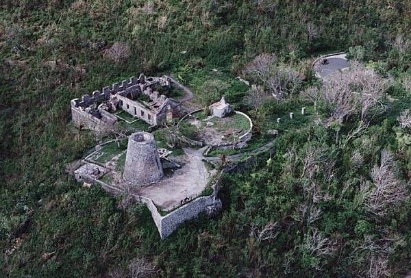
The Danes secured control over the southern Virgin Islands of Saint Thomas, Saint John, and Saint Croix during the 17th and early 18th centuries. Sugarcane, produced by African slave labor, drove the islands' economy during the 18th and early 19th centuries. In 1917, the US purchased the Danish holdings, which had been in economic decline since the abolition of slavery in 1848. On 6 September 2017, Hurricane Irma passed over the northern Virgin Islands of Saint Thomas and Saint John and inflicted severe damage to structures, roads, the airport on Saint Thomas, communications, and electricity. Less than two weeks later, Hurricane Maria passed over the island of Saint Croix in the southern Virgin Islands, inflicting considerable damage with heavy winds and flooding rains.
Visit the Definitions and Notes page to view a description of each topic.
Geography
Location
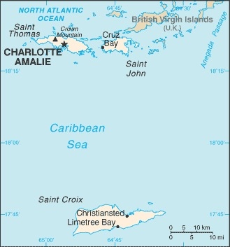
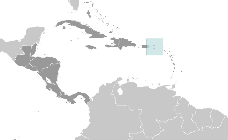
Caribbean, islands between the Caribbean Sea and the North Atlantic Ocean, east of Puerto Rico
Geographic coordinates
18 20 N, 64 50 W
Map references
Central America and the Caribbean
Area - comparative
twice the size of Washington, DC
Land boundaries
total: 0 km
Coastline
188 km
Maritime claims
territorial sea: 12 nm
exclusive economic zone: 200 nm
Climate
subtropical, tempered by easterly trade winds, relatively low humidity, little seasonal temperature variation; rainy season September to November
Terrain
mostly hilly to rugged and mountainous with little flat land
Elevation
highest point: Crown Mountain 474 m
lowest point: Caribbean Sea 0 m
Natural resources
pleasant climate, beaches foster tourism
Land use
agricultural land: 11.5% (2018 est.)
arable land: 2.9% (2018 est.)
permanent crops: 2.9% (2018 est.)
permanent pasture: 5.7% (2018 est.)
forest: 57.4% (2018 est.)
other: 31.1% (2018 est.)
Irrigated land
1 sq km (2012)
Population distribution
while overall population density throughout the islands is relatively low, concentrations appear around Charlotte Amalie on St. Thomas and Christiansted on St. Croix
Natural hazards
several hurricanes in recent years; frequent and severe droughts and floods; occasional earthquakes
Geography - note
important location along the Anegada Passage - a key shipping lane for the Panama Canal; Saint Thomas has one of the best natural deepwater harbors in the Caribbean
People and Society
Nationality
noun: Virgin Islander(s) (US citizens)
adjective: Virgin Islander
Ethnic groups
Black 76%, White 15.6%, Asian 1.4%, other 4.9%, mixed 2.1% (2010 est.)
note: 17.4% self-identify as Latino
Languages
English 71.6%, Spanish or Spanish Creole 17.2%, French or French Creole 8.6%, other 2.5% (2010 est.)
Religions
Protestant 59% (Baptist 42%, Episcopalian 17%), Roman Catholic 34%, other 7%
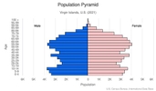
Age structure
0-14 years: 19.71% (male 10,671/female 10,192)
15-24 years: 10.16% (male 5,219/female 5,535)
25-54 years: 36.07% (male 17,844/female 20,342)
55-64 years: 14.24% (male 7,222/female 7,859)
65 years and over: 19.82% (male 9,424/female 11,562) (2021 est.)

Dependency ratios
total dependency ratio: 66
youth dependency ratio: 32
elderly dependency ratio: 34
potential support ratio: 2.9 (2020 est.)
Median age
total: 41.8 years
male: 40.6 years
female: 42.8 years (2020 est.)
Population distribution
while overall population density throughout the islands is relatively low, concentrations appear around Charlotte Amalie on St. Thomas and Christiansted on St. Croix
Urbanization
urban population: 96% of total population (2021)
rate of urbanization: -0.11% annual rate of change (2020-25 est.)
Major urban areas - population
52,000 CHARLOTTE AMALIE (capital) (2018)
Sex ratio
at birth: 1.06 male(s)/female
0-14 years: 1.05 male(s)/female
15-24 years: 0.95 male(s)/female
25-54 years: 0.88 male(s)/female
55-64 years: 0.91 male(s)/female
65 years and over: 0.81 male(s)/female
total population: 0.91 male(s)/female (2020 est.)
Infant mortality rate
total: 7.81 deaths/1,000 live births
male: 8.82 deaths/1,000 live births
female: 6.74 deaths/1,000 live births (2021 est.)
Life expectancy at birth
total population: 80.05 years
male: 76.84 years
female: 83.45 years (2021 est.)
Drinking water source
improved: total: 98.7% of population
unimproved: total: 1.3% of population (2017 est.)
Sanitation facility access
improved: total: 100% of population
unimproved: total: 100% of population (2017 est.)
Environment
Environment - current issues
lack of natural freshwater resources; protection of coral reefs; solid waste management; coastal development; increased boating and overfishing
Climate
subtropical, tempered by easterly trade winds, relatively low humidity, little seasonal temperature variation; rainy season September to November
Land use
agricultural land: 11.5% (2018 est.)
arable land: 2.9% (2018 est.)
permanent crops: 2.9% (2018 est.)
permanent pasture: 5.7% (2018 est.)
forest: 57.4% (2018 est.)
other: 31.1% (2018 est.)
Urbanization
urban population: 96% of total population (2021)
rate of urbanization: -0.11% annual rate of change (2020-25 est.)
Revenue from forest resources
forest revenues: 0% of GDP (2017 est.)
country comparison to the world: 203Waste and recycling
municipal solid waste generated annually: 146,500 tons (2012 est.)
Government
Country name
conventional long form: none
conventional short form: Virgin Islands
former: Danish West Indies
abbreviation: VI
etymology: the myriad islets, cays, and rocks surrounding the major islands reminded Christopher COLUMBUS in 1493 of Saint Ursula and her 11,000 virgin followers (Santa Ursula y las Once Mil Virgenes), which over time shortened to the Virgins (las Virgenes)
Government type
unincorporated organized territory of the US with local self-government; republican form of territorial government with separate executive, legislative, and judicial branches
Dependency status
unincorporated organized territory of the US with policy relations between the Virgin Islands and the federal government under the jurisdiction of the Office of Insular Affairs, US Department of the Interior
Capital
name: Charlotte Amalie
geographic coordinates: 18 21 N, 64 56 W
time difference: UTC-4 (1 hour ahead of Washington, DC, during Standard Time)
etymology: originally called Taphus in Danish - meaning "tap house" or "beer house" because of its many beer halls - the town received a more dignified name in 1691 when it was named Charlotte Amalie in honor of Danish King Christian V’s wife, Charlotte Amalie of Hesse-Kassel (1650–1714)
Administrative divisions
none (territory of the US); there are no first-order administrative divisions as defined by the US Government, but there are 3 islands at the second order; Saint Croix, Saint John, Saint Thomas
Independence
none (territory of the US)
National holiday
Transfer Day (from Denmark to the US), 31 March (1917)
Constitution
history: 22 July 1954 - the Revised Organic Act of the Virgin Islands functions as a constitution for this US territory
amendments: amended several times, last in 2012
Legal system
US common law
Citizenship
see United States
Suffrage
18 years of age; universal; note - island residents are US citizens but do not vote in US presidential elections
Executive branch
chief of state: President Joseph R. BIDEN Jr. (since 20 January 2021); Vice President Kamala D. HARRIS (since 20 January 2021)
head of government: Governor Albert BRYAN, Jr. (since 7 January 2019), Lieutenant Governor Tregenza ROACH (since 7 January 2019)
cabinet: Territorial Cabinet appointed by the governor and confirmed by the Senate
elections/appointments: president and vice president indirectly elected on the same ballot by an Electoral College of 'electors' chosen from each state; president and vice president serve a 4-year term (eligible for a second term); under the US Constitution, residents of the Virgin Islands do not vote in elections for US president and vice president; however, they may vote in the Democratic and Republican presidential primary elections; governor and lieutenant governor directly elected on the same ballot by absolute majority vote in 2 rounds if needed for a 4-year term (eligible for a second term); election last held on 6 November 2018 with a runoff on 20 November 2018 (next to be held in November 2022)
election results:
Albert BRYAN, Jr. elected governor in the second round; percent of vote in first round - Albert BRYAN, Jr. (Democratic Party) 38.1%, Kenneth MAPP (independent) 33.5%, Adlah "Foncie" DONASTORG, Jr. (independent) 16.5%, other 11.9%; percent of vote in second round- Albert BRYAN, Jr. (Democratic Party) 54.5%, Kenneth MAPP (independent) 45.2%, other .3%
Legislative branch
description: unicameral Legislature of the Virgin Islands (15 seats; senators directly elected in single- and multi-seat constituencies by simple majority popular vote to serve 2-year terms)
the Virgin Islands directly elects 1 delegate to the US House of Representatives by simple majority vote to serve a 2-year term
elections: Legislature of the Virgin Islands last held on 6 November 2018 (next to be held in November 2020)
US House of Representatives last held on 6 November 2018 (next to be held in November 2020)
election results: Legislature of the Virgin Islands - percent of vote by party - NA; seats by party - Democratic Party 13, independents 2; composition - men 11, women 4, percent of women 26.7%
delegate to US House of Representatives - seat by party - Democratic Party 1; composition - 1 woman
note: the Virgin Islands to the US House of Representatives can vote when serving on a committee and when the House meets as the Committee of the Whole House, but not when legislation is submitted for a “full floor” House vote
Judicial branch
highest courts: Supreme Court of the Virgin Islands (consists of the chief justice and 2 associate justices); note - court established by the US Congress in 2004 and assumed appellate jurisdiction in 2007
judge selection and term of office: justices appointed by the governor and confirmed by the Virgin Islands Senate; justices serve initial 10-year terms and upon reconfirmation, during the extent of good behavior; chief justice elected to position by peers for a 3-year term
subordinate courts: Superior Court (Territorial Court renamed in 2004); US Court of Appeals for the Third Circuit (has appellate jurisdiction over the District Court of the Virgin Islands; it is a territorial court and is not associated with a US federal judicial district); District Court of the Virgin Islands
Political parties and leaders
Democratic Party [Stacey PLASKELL]
Independent Citizens' Movement or ICM [Dale BLYDEN]
Republican Party [John CANEGATA]
International organization participation
AOSIS (observer), Interpol (subbureau), IOC, UPU, WFTU (NGOs)
Diplomatic representation in the US
none (territory of the US)
Diplomatic representation from the US
none (territory of the US)
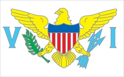
Flag description
white field with a modified US coat of arms in the center between the large blue initials V and I; the coat of arms shows a yellow eagle holding an olive branch in its right talon and three arrows in the left with a superimposed shield of seven red and six white vertical stripes below a blue panel; white is a symbol of purity, the letters stand for the Virgin Islands
National anthem
name: Virgin Islands March
lyrics/music: multiple/Alton Augustus ADAMS, Sr.
note: adopted 1963; serves as a local anthem; as a territory of the US, "The Star-Spangled Banner" is official (see United States)
Economy
Economic overview
Tourism, trade, other services, and rum production are the primary economic activities of the US Virgin Islands (USVI), accounting for most of its GDP and employment. The USVI receives between 2.5 and 3 million tourists a year, mostly from visiting cruise ships. The islands are vulnerable to damage from storms, as evidenced by the destruction from two major hurricanes in 2017. Recovery and rebuilding have continued, but full recovery from these back-to-back hurricanes is years away. The USVI government estimates it will need $7.5 billion, almost twice the territory’s GDP, to rebuild the territory.
The agriculture sector is small and most food is imported. In 2016, government spending (both federal and territorial together) accounted for about 27% of GDP while exports of goods and services, including spending by tourists, accounted for nearly 47%. Federal programs and grants, including rum tax cover-over totaling $482.3 million in 2016, contributed 32.2% of the territory’s total revenues. The economy picked up 0.9% in 2016 and had appeared to be progressing before the 2017 hurricanes severely damaged the territory’s infrastructure and the economy.
Real GDP (purchasing power parity)
$3.872 billion (2016 est.)
$3.759 billion (2015 est.)
$3.622 billion (2014 est.)
note: data are in 2013 dollars
Real GDP growth rate
0.9% (2016 est.)
0.3% (2015 est.)
-1% (2014 est.)
Real GDP per capita
$37,000 (2016 est.)
$35,800 (2015 est.)
$34,500 (2014 est.)
GDP (official exchange rate)
$5.182 billion (2016 est.)
GDP - composition, by sector of origin
agriculture: 2% (2012 est.)
industry: 20% (2012 est.)
services: 78% (2012 est.)
GDP - composition, by end use
household consumption: 68.2% (2016 est.)
government consumption: 26.8% (2016 est.)
investment in fixed capital: 7.5% (2016 est.)
investment in inventories: 15% NA (2016 est.)
exports of goods and services: 46.7% (2016 est.)
imports of goods and services: -64.3% (2016 est.)
Agricultural products
fruit, vegetables, sorghum; Senepol cattle
Industries
tourism, watch assembly, rum distilling, construction, pharmaceuticals, electronics
Labor force - by occupation
agriculture: 1%
industry: 19%
services: 80% (2003 est.)
Population below poverty line
28.9% (2002 est.)
Household income or consumption by percentage share
lowest 10%: NA
highest 10%: NA
Budget
revenues: 1.496 billion (2016 est.)
expenditures: 1.518 billion (2016 est.)
Fiscal year
1 October - 30 September
Exports - partners
Haiti 14%, Guadeloupe 7%, Malaysia 7%, Martinique 7%, Barbados 7%, British Virgin Islands 5% (2019)
Exports - commodities
refined petroleum, jewelry, recreational boats, watches, rum (2019)
Imports - partners
India 18%, Algeria 14%, South Korea 9%, Argentina 9%, Sweden 7%, Brazil 5% (2019)
Imports - commodities
refined petroleum, crude petroleum, rubber piping, jewelry, beer (2019)
Exchange rates
the US dollar is used
Energy
Electricity access
electrification - total population: 100% (2020)
Electricity - installed generating capacity
325,000 kW (2016 est.)
country comparison to the world: 157Electricity - from fossil fuels
98% of total installed capacity (2016 est.)
country comparison to the world: 30Electricity - from nuclear fuels
0% of total installed capacity (2017 est.)
country comparison to the world: 210Electricity - from hydroelectric plants
0% of total installed capacity (2017 est.)
country comparison to the world: 212Electricity - from other renewable sources
2% of total installed capacity (2017 est.)
country comparison to the world: 145Refined petroleum products - consumption
1,240 bbl/day (2016 est.)
country comparison to the world: 203Communications
Telephones - fixed lines
total subscriptions: 76,000 (2017)
subscriptions per 100 inhabitants: 72.41 (2017 est.)
Telecommunication systems
general assessment: modern system with total digital switching, uses fiber-optic cable and microwave radio relay; good interisland and international connections; broadband access; expansion of FttP (Fiber to the Home) markets; LTE launches; regulatory development and expansion in several markets point to investment and focus on data (2020)
domestic: full range of services available; fixed-line 72 per 100 persons and mobile-cellular 75 per 100 (2019)
international: country code - 1-340; landing points for the BSCS, St Thomas-ST Croix System, Southern Caribbean Fiber, Americas II, GCN, MAC, PAN-AM and SAC submarine cable connections to US, the Caribbean, Central and South America; satellite earth stations - NA (2020)
note: the COVID-19 pandemic continues to have a significant impact on production and supply chains globally; since 2020, some aspects of the telecom sector have experienced downturn, particularly in mobile device production; many network operators delayed upgrades to infrastructure; progress towards 5G implementation was postponed or slowed in some countries; consumer spending on telecom services and devices was affected by large-scale job losses and the consequent restriction on disposable incomes; the crucial nature of telecom services as a tool for work and school from home became evident, and received some support from governments
Broadcast media
about a dozen TV broadcast stations including 1 public TV station; multi-channel cable and satellite TV services are available; 24 radio stations
Internet users
total: 67,200 (2021 est.)
percent of population: 64.38% (2019 est.)
Transportation
Airports - with paved runways
total: 2
over 3,047 m: 1
1,524 to 2,437 m: 1 (2019)
Merchant marine
total: 1,868
by type: bulk carrier 91, container ship 39, general cargo 1,205, oil tanker 118, other 415 (2019)
Ports and terminals
major seaport(s): Charlotte Amalie, Christiansted, Cruz Bay, Frederiksted, Limetree Bay
Military and Security
Military - note
defense is the responsibility of the US