Zimbabwe


Introduction
Background
| The hunter-gatherer San people first inhabited the area that eventually became Zimbabwe. Farming communities migrated to the area around A.D. 500 during the Bantu expansion, and Shona-speaking societies began to develop in the Limpopo valley and Zimbabwean highlands around the 9th century. These societies traded with Arab merchants on the Indian Ocean coast and organized under the Kingdom of Mapungubwe in the 11th century. A series of powerful trade-oriented Shona states succeeded Mapungubwe, including the Kingdom of Zimbabwe (ca. 1220-1450), Kingdom of Mutapa (ca. 1450-1760), and the Rozwi Empire. The Rozwi Empire expelled Portuguese colonists from the Zimbabwean plateau but was eventually conquered in 1838 by the Ndebele clan of Zulu general MZILIKAZI during the era of conflict and population displacement known as the Mfecane. In the 1880s, colonists arrived with the British South Africa Company (BSAC) and obtained a written concession for mining rights from Ndebele King LOBENGULA. The king later disavowed the concession and accused the BSAC agents of deceit. The BSAC annexed Mashonaland and subsequently conquered Matabeleland by force during the First Matabele War of 1893-1894 to establish company rule over the territory. BSAC holdings south of the Zambezi River were annexed by the UK in 1923 and became the British colony of Southern Rhodesia. The 1930 Land Apportionment Act restricted black land ownership and established structural racial inequalities that would favor the white minority for decades. A new constitution in 1961 further cemented white minority rule. In 1965, the government under white Prime Minister Ian SMITH unilaterally declared its independence from the UK. London did not recognize Rhodesia’s independence and demanded more voting rights for the black majority in the country. International diplomacy and a liberation struggle by black Zimbabweans finally led to biracial elections in 1979 and independence (as Zimbabwe) in 1980. Robert MUGABE, who led the uprising and became the nation's first prime minister, was the country's only ruler (as president since 1987) from independence until his forced resignation in November 2017. In the mid-1980s, the government tortured and killed thousands of civilians in a crackdown on dissent known as the Gukurahundi campaign. Economic mismanagement and chaotic land redistribution policies following independence periodically crippled the economy and resulted in widespread shortages of basic commodities. General elections in 2002, 2008, and 2013 were severely flawed and widely condemned but allowed MUGABE to remain president. In November 2017, Vice President Emmerson MNANGAGWA became president following a military intervention that forced MUGABE to resign, and MNANGAGWA cemented power by sidelining rivals Grace MUGABE (Robert MUGABE’s wife) and Jonathan MOYO of the G40 faction of the ruling Zimbabwe African National Union-Patriotic Front party. In July 2018, MNANGAGWA won the presidential election after a close contest with opposition candidate Nelson CHAMISA. MNANGAGWA has resorted to the government's longstanding practice of violently disrupting protests and opposition rallies. Economic conditions remained dire under MNANGAGWA, with inflation soaring in 2019 and the country’s export revenues declining dramatically in 2020 due to the COVID-19 pandemic.
|
Visit the Definitions and Notes page to view a description of each topic.
Geography
Location
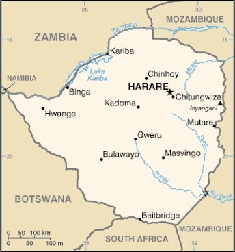
Southern Africa, between South Africa and Zambia
Geographic coordinates
20 00 S, 30 00 E
Map references
Africa

Land boundaries
total: 3,229 km
border countries (4): Botswana 834 km, Mozambique 1402 km, South Africa 230 km, Zambia 763 km
Coastline
0 km (landlocked)
Maritime claims
none (landlocked)
Climate
tropical; moderated by altitude; rainy season (November to March)
Terrain
mostly high plateau with higher central plateau (high veld); mountains in east
Elevation
highest point: Inyangani 2,592 m
lowest point: junction of the Runde and Save Rivers 162 m
mean elevation: 961 m
Natural resources
coal, chromium ore, asbestos, gold, nickel, copper, iron ore, vanadium, lithium, tin, platinum group metals
Land use
agricultural land: 42.5% (2018 est.)
arable land: 10.9% (2018 est.)
permanent crops: 0.3% (2018 est.)
permanent pasture: 31.3% (2018 est.)
forest: 39.5% (2018 est.)
other: 18% (2018 est.)
Irrigated land
1,740 sq km (2012)
Major rivers (by length in km)
Zambezi (shared with Zambia [s]), Angola, Namibia, Botswana, and Mozambique [m]) - 2,740 km; Limpopo (shared with South Africa [s], Botswana, and Mozambique [m]) - 1,800 km
note – [s] after country name indicates river source; [m] after country name indicates river mouth
Major watersheds (area sq km)
Indian Ocean drainage: Zambezi (1,332,412 sq km)
Internal (endorheic basin) drainage: Okavango Basin (863,866 sq km)
Major aquifers
Upper Kalahari-Cuvelai-Upper Zambezi Basin
Population distribution
Aside from major urban agglomerations in Harare and Bulawayo, population distribution is fairly even, with slightly greater overall numbers in the eastern half as shown in this population distribution map
Natural hazards
recurring droughts; floods and severe storms are rare
Geography - note
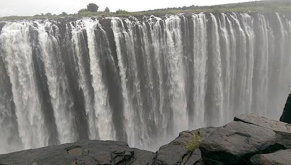
landlocked; the Zambezi forms a natural riverine boundary with Zambia; in full flood (February-April) the massive Victoria Falls on the river forms the world's largest curtain of falling water; Lake Kariba on the Zambia-Zimbabwe border forms the world's largest reservoir by volume (180 cu km; 43 cu mi)
People and Society
Population
14,829,988 (July 2021 est.)
note: estimates for this country explicitly take into account the effects of excess mortality due to AIDS; this can result in lower life expectancy, higher infant mortality, higher death rates, lower population growth rates, and changes in the distribution of population by age and sex than would otherwise be expected
Nationality
noun: Zimbabwean(s)
adjective: Zimbabwean
Ethnic groups
African 99.4% (predominantly Shona; Ndebele is the second largest ethnic group), other 0.4%, unspecified 0.2% (2012 est.)
Languages
Shona (official; most widely spoken), Ndebele (official, second most widely spoken), English (official; traditionally used for official business), 13 minority languages (official; includes Chewa, Chibarwe, Kalanga, Koisan, Nambya, Ndau, Shangani, sign language, Sotho, Tonga, Tswana, Venda, and Xhosa)
Religions
Protestant 74.8% (includes Apostolic 37.5%, Pentecostal 21.8%, other 15.5%), Roman Catholic 7.3%, other Christian 5.3%, traditional 1.5%, Muslim 0.5%, other 0.1%, none 10.5% (2015 est.)
Demographic profile
Zimbabwe’s progress in reproductive, maternal, and child health has stagnated in recent years. According to a 2010 Demographic and Health Survey, contraceptive use, the number of births attended by skilled practitioners, and child mortality have either stalled or somewhat deteriorated since the mid-2000s. Zimbabwe’s total fertility rate has remained fairly stable at about 4 children per woman for the last two decades, although an uptick in the urban birth rate in recent years has caused a slight rise in the country’s overall fertility rate. Zimbabwe’s HIV prevalence rate dropped from approximately 29% to 15% since 1997 but remains among the world’s highest and continues to suppress the country’s life expectancy rate. The proliferation of HIV/AIDS information and prevention programs and personal experience with those suffering or dying from the disease have helped to change sexual behavior and reduce the epidemic.
Historically, the vast majority of Zimbabwe’s migration has been internal – a rural-urban flow. In terms of international migration, over the last 40 years Zimbabwe has gradually shifted from being a destination country to one of emigration and, to a lesser degree, one of transit (for East African illegal migrants traveling to South Africa). As a British colony, Zimbabwe attracted significant numbers of permanent immigrants from the UK and other European countries, as well as temporary economic migrants from Malawi, Mozambique, and Zambia. Although Zimbabweans have migrated to South Africa since the beginning of the 20th century to work as miners, the first major exodus from the country occurred in the years before and after independence in 1980. The outward migration was politically and racially influenced; a large share of the white population of European origin chose to leave rather than live under a new black-majority government.
In the 1990s and 2000s, economic mismanagement and hyperinflation sparked a second, more diverse wave of emigration. This massive out migration – primarily to other southern African countries, the UK, and the US – has created a variety of challenges, including brain drain, illegal migration, and human smuggling and trafficking. Several factors have pushed highly skilled workers to go abroad, including unemployment, lower wages, a lack of resources, and few opportunities for career growth.
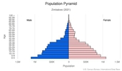
Age structure
0-14 years: 38.32% (male 2,759,155/female 2,814,462)
15-24 years: 20.16% (male 1,436,710/female 1,495,440)
25-54 years: 32.94% (male 2,456,392/female 2,334,973)
55-64 years: 4.07% (male 227,506/female 363,824)
65 years and over: 4.52% (male 261,456/female 396,396) (2020 est.)

Dependency ratios
total dependency ratio: 81.6
youth dependency ratio: 76.1
elderly dependency ratio: 5.5
potential support ratio: 18.3 (2020 est.)
Median age
total: 20.5 years
male: 20.3 years
female: 20.6 years (2020 est.)
Population distribution
Aside from major urban agglomerations in Harare and Bulawayo, population distribution is fairly even, with slightly greater overall numbers in the eastern half as shown in this population distribution map
Urbanization
urban population: 32.3% of total population (2021)
rate of urbanization: 2.41% annual rate of change (2020-25 est.)
Major urban areas - population
1.542 million HARARE (capital) (2021)
Sex ratio
at birth: 1.03 male(s)/female
0-14 years: 0.98 male(s)/female
15-24 years: 0.96 male(s)/female
25-54 years: 1.05 male(s)/female
55-64 years: 0.63 male(s)/female
65 years and over: 0.66 male(s)/female
total population: 0.96 male(s)/female (2020 est.)
Mother's mean age at first birth
20.3 years (2015 est.)
note: median age at first birth among women 25-49
Maternal mortality ratio
458 deaths/100,000 live births (2017 est.)
country comparison to the world: 24Infant mortality rate
total: 29.41 deaths/1,000 live births
male: 33.15 deaths/1,000 live births
female: 25.56 deaths/1,000 live births (2021 est.)
Life expectancy at birth
total population: 62.83 years
male: 60.7 years
female: 65.02 years (2021 est.)
Contraceptive prevalence rate
66.8% (2015)
Drinking water source
improved: urban: 98% of population
rural: 67.4% of population
total: 77.3% of population
unimproved: urban: 2% of population
rural: 32.6% of population
total: 22.7% of population (2017 est.)
Current Health Expenditure
4.7% (2018)
Physicians density
0.21 physicians/1,000 population (2018)
Hospital bed density
1.7 beds/1,000 population (2011)
Sanitation facility access
improved: urban: 96.1% of population
rural: 49% of population
total: 64.2% of population
unimproved: urban: 3.9% of population
rural: 51% of population
total: 35.8% of population (2017 est.)
Major infectious diseases
degree of risk: high (2020)
food or waterborne diseases: bacterial and protozoal diarrhea, hepatitis A, and typhoid fever
vectorborne diseases: malaria and dengue fever
water contact diseases: schistosomiasis
animal contact diseases: rabies
Literacy
definition: age 15 and over can read and write English
total population: 86.5%
male: 88.5%
female: 84.6% (2015)
School life expectancy (primary to tertiary education)
total: 11 years
male: 12 years
female: 11 years (2013)
Unemployment, youth ages 15-24
total: 27.5%
male: 25%
female: 31.4% (2019 est.)
Environment
Environment - current issues
deforestation; soil erosion; land degradation; air and water pollution; the black rhinoceros herd - once the largest concentration of the species in the world - has been significantly reduced by poaching; poor mining practices have led to toxic waste and heavy metal pollution
Environment - international agreements
party to: Biodiversity, Climate Change, Climate Change-Kyoto Protocol, Climate Change-Paris Agreement, Comprehensive Nuclear Test Ban, Desertification, Endangered Species, Hazardous Wastes, Law of the Sea, Ozone Layer Protection, Wetlands
signed, but not ratified: none of the selected agreements
Air pollutants
particulate matter emissions: 19.35 micrograms per cubic meter (2016 est.)
carbon dioxide emissions: 10.98 megatons (2016 est.)
methane emissions: 12.1 megatons (2020 est.)
Climate
tropical; moderated by altitude; rainy season (November to March)
Land use
agricultural land: 42.5% (2018 est.)
arable land: 10.9% (2018 est.)
permanent crops: 0.3% (2018 est.)
permanent pasture: 31.3% (2018 est.)
forest: 39.5% (2018 est.)
other: 18% (2018 est.)
Urbanization
urban population: 32.3% of total population (2021)
rate of urbanization: 2.41% annual rate of change (2020-25 est.)
Revenue from forest resources
forest revenues: 1.61% of GDP (2018 est.)
country comparison to the world: 39Major infectious diseases
degree of risk: high (2020)
food or waterborne diseases: bacterial and protozoal diarrhea, hepatitis A, and typhoid fever
vectorborne diseases: malaria and dengue fever
water contact diseases: schistosomiasis
animal contact diseases: rabies
Food insecurity
widespread lack of access: due to High food prices and economic downturn - a well above-average cereal production in 2021 has resulted in an improvement in food security; an estimated 1.8 million people are still assessed to be food insecure in the July−September period, about half the level in the previous year, largely on account of poor food access due to prevailing high prices and reduced incomes owing to the effects of the economic downturn; the negative effects of the COVID‑19 pandemic aggravated conditions, particularly with regard to income levels due to market instability from COVID‑19 lockdown measures
Waste and recycling
municipal solid waste generated annually: 1,449,752 tons (2015 est.)
municipal solid waste recycled annually: 231,960 tons (2005 est.)
percent of municipal solid waste recycled: 16% (2005 est.)
Major rivers (by length in km)
Zambezi (shared with Zambia [s]), Angola, Namibia, Botswana, and Mozambique [m]) - 2,740 km; Limpopo (shared with South Africa [s], Botswana, and Mozambique [m]) - 1,800 km
note – [s] after country name indicates river source; [m] after country name indicates river mouth
Major watersheds (area sq km)
Indian Ocean drainage: Zambezi (1,332,412 sq km)
Internal (endorheic basin) drainage: Okavango Basin (863,866 sq km)
Major aquifers
Upper Kalahari-Cuvelai-Upper Zambezi Basin
Total water withdrawal
municipal: 487.7 million cubic meters (2017 est.)
industrial: 81.4 million cubic meters (2017 est.)
agricultural: 2.77 billion cubic meters (2017 est.)
Total renewable water resources
20 billion cubic meters (2017 est.)
Government
Country name
conventional long form: Republic of Zimbabwe
conventional short form: Zimbabwe
former: Southern Rhodesia, Rhodesia, Zimbabwe-Rhodesia
etymology: takes its name from the Kingdom of Zimbabwe (13th-15th century) and its capital of Great Zimbabwe, the largest stone structure in pre-colonial southern Africa
Government type
presidential republic
Capital
name: Harare
geographic coordinates: 17 49 S, 31 02 E
time difference: UTC+2 (7 hours ahead of Washington, DC, during Standard Time)
etymology: named after a village of Harare at the site of the present capital; the village name derived from a Shona chieftain, Ne-harawa, whose name meant "he who does not sleep"
Administrative divisions
8 provinces and 2 cities* with provincial status; Bulawayo*, Harare*, Manicaland, Mashonaland Central, Mashonaland East, Mashonaland West, Masvingo, Matabeleland North, Matabeleland South, Midlands
Independence
18 April 1980 (from the UK)
National holiday
Independence Day, 18 April (1980)
Constitution
history: previous 1965 (at Rhodesian independence), 1979 (Lancaster House Agreement), 1980 (at Zimbabwean independence); latest final draft completed January 2013, approved by referendum 16 March 2013, approved by Parliament 9 May 2013, effective 22 May 2013
amendments: proposed by the Senate or by the National Assembly; passage requires two-thirds majority vote by the membership of both houses of Parliament and assent of the president of the republic; amendments to constitutional chapters on fundamental human rights and freedoms and on agricultural lands also require approval by a majority of votes cast in a referendum; amended many times, last in 2017
Legal system
mixed legal system of English common law, Roman-Dutch civil law, and customary law
International law organization participation
has not submitted an ICJ jurisdiction declaration; non-party state to the ICCt
Citizenship
citizenship by birth: no
citizenship by descent only: the father must be a citizen of Zimbabwe; in the case of a child born out of wedlock, the mother must be a citizen
dual citizenship recognized: no
residency requirement for naturalization: 5 years
Suffrage
18 years of age; universal
Executive branch
chief of state: President Emmerson Dambudzo MNANGAGWA (since 24 November 2017); First Vice President Constantino CHIWENGA (since 28 December 2017); note - Robert Gabriel MUGABE resigned on 21 November 2017, after ruling for 37 years
head of government: President Emmerson Dambudzo MNANGAGWA (since 24 November 2017); Vice President Constantino CHIWENGA (since 28 December 2017); Vice President (vacant)
cabinet: Cabinet appointed by president, responsible to National Assembly
elections/appointments: each presidential candidate nominated with a nomination paper signed by at least 10 registered voters (at least 1 candidate from each province) and directly elected by absolute majority popular vote in 2 rounds if needed for a 5-year term (no term limits); election last held on 3 July 2018 (next to be held in 2023); co-vice presidents drawn from party leadership
election results: Emmerson MNANGAGWA reelected president in 1st round of voting; percent of vote - Emmerson MNANGAGWA (ZANU-PF) 50.8%, Nelson CHAMISA (MDC-T) 44.3%, Thokozani KHUPE (MDC-N) .9%, other 3%
Legislative branch
description: bicameral Parliament consists of:
Senate (80 seats; 60 members directly elected in multi-seat constituencies - 6 seats in each of the 10 provinces - by proportional representation vote, 16 indirectly elected by the regional governing councils, 2 reserved for the National Council Chiefs, and 2 reserved for members with disabilities; members serve 5-year terms)
National Assembly (270 seats; 210 members directly elected in single-seat constituencies by simple majority vote and 60 seats reserved for women directly elected by proportional representation vote; members serve 5-year terms)
elections: Senate - last held for elected member on 30 July 2018 (next to be held in 2023)
National Assembly - last held on 30 July 2018 (next to be held in 2023)
election results: Senate - percent of vote by party - NA; seats by party - ZANU-PF 34, MDC Alliance 25, Chiefs 18, people with disabilities 2, MDC-T 1; composition - men 45, women 35, percent of women 43.8%
National Assembly - percent of vote by party - NA; seats by party - ZANU-PF 179, MDC Alliance 88, MDC-T 1, NPF 1, independent 1; composition - men 185, women 25, percent of women 31.5%; note - total Parliament percent of women 34.3%
Judicial branch
highest courts: Supreme Court (consists of the chief justice and 4 judges); Constitutional Court (consists of the chief and deputy chief justices and 9 judges)
judge selection and term of office: Supreme Court judges appointed by the president upon recommendation of the Judicial Service Commission, an independent body consisting of the chief justice, Public Service Commission chairman, attorney general, and 2-3 members appointed by the president; judges normally serve until age 65 but can elect to serve until age 70; Constitutional Court judge appointment NA; judges serve nonrenewable 15-year terms
subordinate courts: High Court; Labor Court; Administrative Court; regional magistrate courts; customary law courts; special courts
Political parties and leaders
MDC Alliance [Nelson CHAMISA]
Movement for Democratic Change - MDC-T [Douglas MWONZORA]
National People's Party or NPP [Joyce MUJURU] (formerly Zimbabwe People First or ZimPF)
Zimbabwe African National Union-Patriotic Front or ZANU-PF [Emmerson Dambudzo MNANGAGWA]
Zimbabwe African Peoples Union or ZAPU [Sibangalizwe NKOMO]
International organization participation
ACP, AfDB, AU, COMESA, FAO, G-15, G-77, IAEA, IBRD, ICAO, ICRM, IDA, IFAD, IFC, IFRCS, ILO, IMF, IMO, Interpol, IOC, IOM, IPU, ISO, ITSO, ITU, ITUC (NGOs), MIGA, NAM, OPCW, PCA, SADC, UN, UNAMID, UNCTAD, UNESCO, UNIDO, UNMIL, UNMISS, UNOCI, UNWTO, UPU, WCO, WFTU (NGOs), WHO, WIPO, WMO, WTO
Diplomatic representation in the US
chief of mission: Ambassador Tadeous Tafirenyika CHIFAMBA (since 7 July 2021);
chancery: 1608 New Hampshire Avenue NW, Washington, DC 20009
telephone: [1] (202) 332-7100
FAX: [1] (202) 483-9326
email address and website:
general@zimembassydc.org
https://zimembassydc.org/
Diplomatic representation from the US
chief of mission: Ambassador Thomas R. HASTINGS (since August 2021)
embassy: 2 Lorraine Drive, Bluffhill, Harare
mailing address: 2180 Harare Place, Washington DC 20521-2180
telephone: [263] 867-701-1000
FAX: [263] 24-233-4320
email address and website:
consularharare@state.gov
https://zw.usembassy.gov/
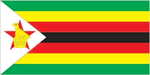
Flag description
seven equal horizontal bands of green (top), yellow, red, black, red, yellow, and green with a white isosceles triangle edged in black with its base on the hoist side; a yellow Zimbabwe bird representing the long history of the country is superimposed on a red five-pointed star in the center of the triangle, which symbolizes peace; green represents agriculture, yellow mineral wealth, red the blood shed to achieve independence, and black stands for the native people
National symbol(s)
Zimbabwe bird symbol, African fish eagle, flame lily; national colors: green, yellow, red, black, white
National anthem
name: "Kalibusiswe Ilizwe leZimbabwe" [Northern Ndebele language] "Simudzai Mureza WeZimbabwe" [Shona] (Blessed Be the Land of Zimbabwe)
lyrics/music: Solomon MUTSWAIRO/Fred Lecture CHANGUNDEGA
note: adopted 1994
Economy
Economic overview
Zimbabwe's economy depends heavily on its mining and agriculture sectors. Following a contraction from 1998 to 2008, the economy recorded real growth of more than 10% per year in the period 2010-13, before falling below 3% in the period 2014-17, due to poor harvests, low diamond revenues, and decreased investment. Lower mineral prices, infrastructure and regulatory deficiencies, a poor investment climate, a large public and external debt burden, and extremely high government wage expenses impede the country’s economic performance.
Until early 2009, the Reserve Bank of Zimbabwe (RBZ) routinely printed money to fund the budget deficit, causing hyperinflation. Adoption of a multi-currency basket in early 2009 - which allowed currencies such as the Botswana pula, the South Africa rand, and the US dollar to be used locally - reduced inflation below 10% per year. In January 2015, as part of the government’s effort to boost trade and attract foreign investment, the RBZ announced that the Chinese renmimbi, Indian rupee, Australian dollar, and Japanese yen would be accepted as legal tender in Zimbabwe, though transactions were predominantly carried out in US dollars and South African rand until 2016, when the rand’s devaluation and instability led to near-exclusive use of the US dollar. The government in November 2016 began releasing bond notes, a parallel currency legal only in Zimbabwe which the government claims will have a one-to-one exchange ratio with the US dollar, to ease cash shortages. Bond notes began trading at a discount of up to 10% in the black market by the end of 2016.
Zimbabwe’s government entered a second Staff Monitored Program with the IMF in 2014 and undertook other measures to reengage with international financial institutions. Zimbabwe repaid roughly $108 million in arrears to the IMF in October 2016, but financial observers note that Zimbabwe is unlikely to gain new financing because the government has not disclosed how it plans to repay more than $1.7 billion in arrears to the World Bank and African Development Bank. International financial institutions want Zimbabwe to implement significant fiscal and structural reforms before granting new loans. Foreign and domestic investment continues to be hindered by the lack of land tenure and titling, the inability to repatriate dividends to investors overseas, and the lack of clarity regarding the government’s Indigenization and Economic Empowerment Act.
Real GDP (purchasing power parity)
$40.79 billion note: data are in 2017 dollars (2020 est.)
$44.34 billion note: data are in 2017 dollars (2019 est.)
$48.25 billion note: data are in 2017 dollars (2018 est.)
note: data are in 2017 dollars
Real GDP growth rate
3.7% (2017 est.)
0.7% (2016 est.)
1.4% (2015 est.)
Real GDP per capita
$2,700 note: data are in 2017 dollars (2020 est.)
$3,000 note: data are in 2017 dollars (2019 est.)
$3,300 note: data are in 2017 dollars (2018 est.)
note: data are in 2017 dollars
GDP (official exchange rate)
$21.441 billion (2019 est.)
Inflation rate (consumer prices)
241.7% (2019 est.)
10.6% (2018 est.)
0.9% (2017 est.)
GDP - composition, by sector of origin
agriculture: 12% (2017 est.)
industry: 22.2% (2017 est.)
services: 65.8% (2017 est.)
GDP - composition, by end use
household consumption: 77.6% (2017 est.)
government consumption: 24% (2017 est.)
investment in fixed capital: 12.6% (2017 est.)
investment in inventories: 0% (2017 est.)
exports of goods and services: 25.6% (2017 est.)
imports of goods and services: -39.9% (2017 est.)
Agricultural products
sugar cane, maize, milk, tobacco, cassava, vegetables, bananas, beef, cotton, oranges
Industries
mining (coal, gold, platinum, copper, nickel, tin, diamonds, clay, numerous metallic and nonmetallic ores), steel; wood products, cement, chemicals, fertilizer, clothing and footwear, foodstuffs, beverages
Labor force - by occupation
agriculture: 67.5%
industry: 7.3%
services: 25.2% (2017 est.)
Unemployment rate
11.3% (2014 est.)
80% (2005 est.)
note: data include both unemployment and underemployment; true unemployment is unknown and, under current economic conditions, unknowable
Population below poverty line
38.3% (2019 est.)
Gini Index coefficient - distribution of family income
44.3 (2017 est.)
50.1 (2006)
Household income or consumption by percentage share
lowest 10%: 2%
highest 10%: 40.4% (1995)
Budget
revenues: 3.8 billion (2017 est.)
expenditures: 5.5 billion (2017 est.)
Fiscal year
calendar year
Current account balance
-$716 million (2017 est.)
-$553 million (2016 est.)
Exports - partners
United Arab Emirates 40%, South Africa 23%, Mozambique 9% (2019)
Exports - commodities
gold, tobacco, iron alloys, nickel, diamonds, jewelry (2019)
Imports - partners
South Africa 41%, Singapore 23%, China 8% (2019)
Imports - commodities
refined petroleum, delivery trucks, packaged medicines, fertilizers, tractors (2019)
Reserves of foreign exchange and gold
$431.8 million (31 December 2017 est.)
$407.2 million (31 December 2016 est.)
Debt - external
$9.357 billion (31 December 2017 est.)
$10.14 billion (31 December 2016 est.)
Exchange rates
Zimbabwean dollars (ZWD) per US dollar -
82.3138 (2020 est.)
16.44579 (2019 est.)
322.355 (2018 est.)
234.25 (2010)
note: the dollar was adopted as a legal currency in 2009; since then the Zimbabwean dollar has experienced hyperinflation and is essentially worthless
Unemployment, youth ages 15-24
total: 27.5%
male: 25%
female: 31.4% (2019 est.)
Energy
Electricity access
electrification - total population: 53% (2019)
electrification - urban areas: 89% (2019)
electrification - rural areas: 36% (2019)
Electricity - installed generating capacity
2.122 million kW (2016 est.)
country comparison to the world: 111Electricity - from fossil fuels
58% of total installed capacity (2016 est.)
country comparison to the world: 136Electricity - from nuclear fuels
0% of total installed capacity (2017 est.)
country comparison to the world: 214Electricity - from hydroelectric plants
37% of total installed capacity (2017 est.)
country comparison to the world: 58Electricity - from other renewable sources
5% of total installed capacity (2017 est.)
country comparison to the world: 109Refined petroleum products - consumption
27,000 bbl/day (2016 est.)
country comparison to the world: 127Communications
Telephones - fixed lines
total subscriptions: 252,067 (2020)
subscriptions per 100 inhabitants: 1.7 (2020 est.)
Telephones - mobile cellular
total subscriptions: 13,191,708 (2020)
subscriptions per 100 inhabitants: 88.76 (2020 est.)
Telecommunication systems
general assessment: the pandemic, drought, and rising hyperinflation have devastated the economy and hindered foreign investment; regulator extended tax exemption for Huawei, raising concerns of independence; mobile tariffs were increased three times since mid-2019, raising consumer prices; Internet is limited, exacerbated by inadequate electricity; mobile Internet connections make up almost all Internet connections; competition has driven some expansion of the telecommunications sector, though operators warn that lack of government investment will cause further deterioration, especially in rural areas; mobile network operators continue to invest in e-commerce and e-banking; slow progress on national and international fiber backbone network, as well as 3G and LTE mobile-broadband services; international bandwidth through submarine cables via neighboring countries (2020)
domestic: consists of microwave radio relay links, open-wire lines, radiotelephone communication stations, fixed wireless local loop installations, fiber-optic cable, VSAT terminals, and a substantial mobile-cellular network; Internet connection is most readily available in Harare and major towns; two government owned and two private cellular providers; fixed-line 2 per 100 and mobile-cellular 90 per 100 (2019)
international: country code - 263; fiber-optic connections to neighboring states provide access to international networks via undersea cable; satellite earth stations - 2 Intelsat; 5 international digital gateway exchanges
note: the COVID-19 pandemic continues to have a significant impact on production and supply chains globally; since 2020, some aspects of the telecom sector have experienced downturn, particularly in mobile device production; many network operators delayed upgrades to infrastructure; progress towards 5G implementation was postponed or slowed in some countries; consumer spending on telecom services and devices was affected by large-scale job losses and the consequent restriction on disposable incomes; the crucial nature of telecom services as a tool for work and school from home became evident, and received some support from governments
Broadcast media
government owns all local radio and TV stations; foreign shortwave broadcasts and satellite TV are available to those who can afford antennas and receivers; in rural areas, access to TV broadcasts is extremely limited; analog TV only, no digital service (2017)
Internet users
total: 5.01 million (2021)
percent of population: 27.06% (2019 est.)
Broadband - fixed subscriptions
total: 203,461 (2020)
subscriptions per 100 inhabitants: 1.37 (2020 est.)
Transportation
National air transport system
number of registered air carriers: 2 (2020)
inventory of registered aircraft operated by air carriers: 12
annual passenger traffic on registered air carriers: 285,539 (2018)
annual freight traffic on registered air carriers: 670,000 mt-km (2018)
Airports - with paved runways
total: 17
over 3,047 m: 3
2,438 to 3,047 m: 2
1,524 to 2,437 m: 5
914 to 1,523 m: 7 (2013)
Airports - with unpaved runways
total: 179
1,524 to 2,437 m: 3
914 to 1,523 m: 104
under 914 m: 72 (2013)
Pipelines
270 km refined products (2013)
Railways
total: 3,427 km (2014)
narrow gauge: 3,427 km 1.067-m gauge (313 km electrified) (2014)
Roadways
total: 97,267 km (2019)
paved: 18,481 km (2019)
unpaved: 78,786 km (2019)
Waterways
(some navigation possible on Lake Kariba) (2011)
Ports and terminals
river port(s): Binga, Kariba (Zambezi)
Military and Security
Military and security forces
Zimbabwe Defense Forces (ZDF): Zimbabwe National Army (ZNA), Air Force of Zimbabwe (AFZ) (2021)
Military expenditures
0.7% of GDP (2019 est.)
1.2% of GDP (2018 est.)
1.5% of GDP (2017 est.)
1.8% of GDP (2016 est.)
1.9% of GDP (2015 est.)
Military and security service personnel strengths
information varies; approximately 30,000 active duty troops, including about 4,000 serving in the Air Force (2021)
Military equipment inventories and acquisitions
the ZDF inventory is comprised mostly of older Chinese- and Russian-origin equipment; since 2000, China is the leading arms supplier to the ZDF, although there are no recorded deliveries of weapons since 2006; since the early 2000s, Zimbabwe has been under an arms embargo from the European Union, as well as targeted sanctions from Australia, Canada, New Zealand, and the US (2020)
Military service age and obligation
18-22 years of age for voluntary military service (18-24 for officer cadets; 18-30 for technical/specialist personnel); no conscription; women are eligible to serve (2021)
Military - note
the ZDF was formed after independence from the former Rhodesian Army and the two guerrilla forces that opposed it during the Rhodesian Civil War (aka "Bush War") of the 1970s, the Zimbabwe African National Liberation Army (ZANLA) and the Zimbabwe People's Revolutionary Army (ZIPRA); internal security is a key current responsibility, and the military continues to play an active role in the country’s politics since the coup of 2017 (2021)
Transnational Issues
Disputes - international
Namibia has supported, and in 2004 Zimbabwe dropped objections to, plans between Botswana and Zambia to build a bridge over the Zambezi River, thereby de facto recognizing a short, but not clearly delimited, Botswana-Zambia boundary in the river; South Africa has placed military units to assist police operations along the border of Lesotho, Zimbabwe, and Mozambique to control smuggling, poaching, and illegal migration
Refugees and internally displaced persons
refugees (country of origin): 11,199 (Democratic Republic of Congo) (refugees and asylum seekers) (2021)
Trafficking in persons
current situation: Zimbabwe is a source, transit, and destination country for men, women, and children subjected to forced labor and sex trafficking; Zimbabwean women and girls from towns bordering South Africa, Mozambique, and Zambia are subjected to forced labor, including domestic servitude, and prostitution catering to long-distance truck drivers; Zimbabwean men, women, and children experience forced labor in agriculture and domestic servitude in rural areas; family members may recruit children and other relatives from rural areas with promises of work or education in cities and towns where they end up in domestic servitude and sex trafficking; Zimbabwean women and men are lured into exploitative labor situations in South Africa and other neighboring countries
tier rating: Tier 3 - Zimbabwe does not fully comply with the minimum standards for the elimination of trafficking and is not making significant efforts to do so; the government passed an anti-trafficking law in 2014 defining trafficking in persons as a crime of transportation and failing to capture the key element of the international definition of human trafficking – the purpose of exploitation – which prevents the law from being comprehensive or consistent with the 2000 UN TIP Protocol that Zimbabwe acceded to in 2013; the government did not report on anti-trafficking law enforcement efforts during 2014, and corruption in law enforcement and the judiciary remain a concern; authorities made minimal efforts to identify and protect trafficking victims, relying on NGOs to identify and assist victims; Zimbabwe’s 2014 anti-trafficking law required the opening of 10 centers for trafficking victims, but none were established during the year; five existing shelters for vulnerable children and orphans may have accommodated child victims; in January 2015, an inter-ministerial anti-trafficking committee was established, but it is unclear if the committee ever met or initiated any activities (2015)
Illicit drugs
transit point for cannabis and South Asian heroin, methaqualone, and methamphetamines en route to South Africa