Isle of Man
Introduction
Background
Part of the Norwegian Kingdom of the Hebrides until the 13th century when it was ceded to Scotland, the isle came under the British crown in 1765. Current concerns include reviving the almost extinct Manx Gaelic language. The Isle of Man is a British Crown dependency, which makes it a self-governing possession of the British Crown that is not part of the UK. The UK Government, however, remains constitutionally responsible for its defense and international representation.
Visit the Definitions and Notes page to view a description of each topic.
Geography
Location
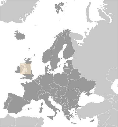
Western Europe, island in the Irish Sea, between Great Britain and Ireland
Geographic coordinates
54 15 N, 4 30 W
Map references
Europe
Area - comparative
slightly more than three times the size of Washington, DC
Land boundaries
total: 0 km
Coastline
160 km
Maritime claims
territorial sea: 12 nm
exclusive fishing zone: 12 nm
Climate
temperate; cool summers and mild winters; overcast about a third of the time
Terrain
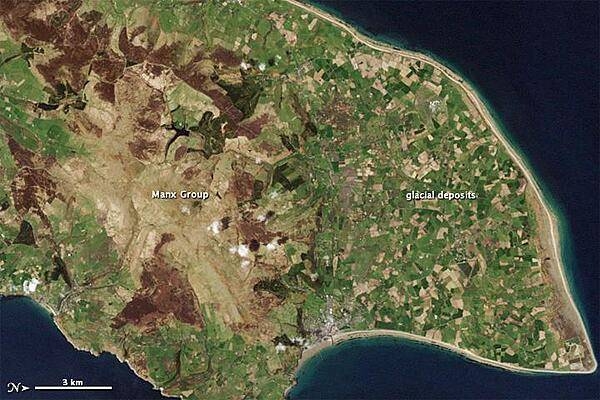
hills in north and south bisected by central valley
Elevation
highest point: Snaefell 621 m
lowest point: Irish Sea 0 m
Land use
agricultural land: 74.7% (2018 est.)
arable land: 43.8% (2018 est.)
permanent crops: 0% (2018 est.)
permanent pasture: 30.9% (2018 est.)
forest: 6.1% (2018 est.)
other: 19.2% (2018 est.)
Irrigated land
0 sq km (2022)
Population distribution
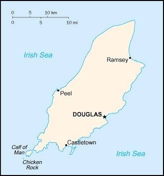
most people concentrated in cities and large towns of which Douglas, in the southeast, is the largest
Natural hazards
occasional high winds and rough seas
Geography - note
one small islet, the Calf of Man, lies to the southwest and is a bird sanctuary
People and Society
Nationality
noun: Manxman (men), Manxwoman (women)
adjective: Manx
Ethnic groups
White 94.7%, Asian 3.1%, Mixed 1%, Black 0.6%, other 0.4% (2021 est.)
note: data represent population by nationality
Languages
English, Manx Gaelic (about 2% of the population has some knowledge)
Religions
Christian 54.7%, Muslim 0.5%, Buddhist 0.5%, Hindu 0.4%, Jewish 0.2%, none 43.8% (2021 est.)
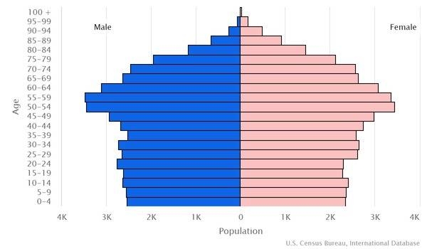
Age structure
0-14 years: 16.28% (male 7,688/female 7,046)
15-24 years: 11.02% (male 5,328/female 4,642)
25-54 years: 37.8% (male 17,080/female 17,131)
55-64 years: 13.82% (male 6,284/female 6,219)
65 years and over: 21.08% (male 9,023/female 10,058) (2020 est.)
Dependency ratios
total dependency ratio: 58.6
youth dependency ratio: 23.6
elderly dependency ratio: 34.9
potential support ratio: 2.9 (2021)
Median age
total: 44.6 years
male: 43.6 years
female: 45.6 years (2020 est.)
Population distribution
most people concentrated in cities and large towns of which Douglas, in the southeast, is the largest
Urbanization
urban population: 53.5% of total population (2023)
rate of urbanization: 0.97% annual rate of change (2020-25 est.)
Major urban areas - population
27,000 DOUGLAS (capital) (2018)
Sex ratio
at birth: 1.08 male(s)/female
0-14 years: 1.08 male(s)/female
15-24 years: 1.18 male(s)/female
25-54 years: 1 male(s)/female
55-64 years: 1.02 male(s)/female
65 years and over: 0.75 male(s)/female
total population: 1.01 male(s)/female (2022 est.)
Infant mortality rate
total: 4.24 deaths/1,000 live births
male: 4.59 deaths/1,000 live births
female: 3.85 deaths/1,000 live births (2022 est.)
Life expectancy at birth
total population: 82.04 years
male: 80.23 years
female: 84 years (2022 est.)
Drinking water source
improved: urban: NA
rural: NA
total: 99.1% of population
unimproved: urban: NA
rural: NA
total: 0.9% of population (2020)
Sanitation facility access
improved: urban: NA
rural: NA
total: NA
unimproved: urban: NA
rural: NA
total: NA
Literacy
total population: NA
male: NA
female: NA
Youth unemployment rate (ages 15-24)
total: 10.1%
male: 11.8%
female: 8.2% (2011 est.)
Environment
Environment - current issues
air pollution, marine pollution; waste disposal (both household and industrial)
Climate
temperate; cool summers and mild winters; overcast about a third of the time
Land use
agricultural land: 74.7% (2018 est.)
arable land: 43.8% (2018 est.)
permanent crops: 0% (2018 est.)
permanent pasture: 30.9% (2018 est.)
forest: 6.1% (2018 est.)
other: 19.2% (2018 est.)
Urbanization
urban population: 53.5% of total population (2023)
rate of urbanization: 0.97% annual rate of change (2020-25 est.)
Revenue from forest resources
forest revenues: 0% of GDP (2017 est.)
country comparison to the world: 175Waste and recycling
municipal solid waste generated annually: 50,551 tons (2011 est.)
municipal solid waste recycled annually: 25,276 tons (2011 est.)
percent of municipal solid waste recycled: 50% (2011 est.)
Government
Country name
conventional long form: none
conventional short form: Isle of Man
abbreviation: I.O.M.
etymology: the name "man" may be derived from the Celtic word for "mountain"
Government type
parliamentary democracy (Tynwald)
Dependency status
British crown dependency
Capital
name: Douglas
geographic coordinates: 54 09 N, 4 29 W
time difference: UTC 0 (5 hours ahead of Washington, DC, during Standard Time)
daylight saving time: +1hr, begins last Sunday in March; ends last Sunday in October
etymology: name derives from the Dhoo and Glass Rivers, which flow through the valley in which the town is located and which in Manx mean the "dark" and the "light" rivers respectively
Administrative divisions
none; there are no first-order administrative divisions as defined by the US Government, but there are 24 local authorities each with its own elections
Independence
none (British Crown dependency)
National holiday
Tynwald Day, 5 July (1417); date Tynwald Day was first recorded
Constitution
history: development of the Isle of Man constitution dates to at least the 14th century
amendments: proposed as a bill in the House of Keys, by the "Government," by a "Member of the House," or through petition to the House or Legislative Council; passage normally requires three separate readings and approval of at least 13 House members; following both House and Council agreement, assent is required by the lieutenant governor on behalf of the Crown; the constitution has been expanded and amended many times, last in 2020
Legal system
the laws of the UK apply where applicable and include Manx statutes
Citizenship
see United Kingdom
Suffrage
16 years of age; universal
Executive branch
chief of state: Lord of Mann King CHARLES III (since 8 September 2022); represented by Lieutenant Governor Sir John LORIMER (since 29 September 2021)
head of government: Chief Minister Alfred CANNAN (since 12 October 2021)
cabinet: Council of Ministers appointed by the lieutenant governor
elections/appointments: the monarchy is hereditary; lieutenant governor appointed by the monarch; chief minister indirectly elected by the Tynwald for a 5-year term (eligible for second term); election last held on 23 September 2021 (next to be held in 2026)
election results: 2021: Alfred CANNAN (independent) elected chief minister; Tynwald House of Keys vote - 21 of 24
2016: Howard QUAYLE elected chief minister; Tynwald House of Keys vote - 21 of 33
Legislative branch
description: bicameral Tynwald or the High Court of Tynwald consists of:
Legislative Council (11 seats; includes the President of Tynwald, 2 ex-officio members - the Lord Bishop of Sodor and Man and the attorney general (non-voting) - and 8 members indirectly elected by the House of Keys with renewal of 4 members every 2 years; elected members serve 4-year terms)
House of Keys (24 seats; 2 members directly elected by simple majority vote from 12 constituencies to serve 5-year terms)
elections:
Legislative Council - last held 29 February 2020 (next to be held on 28 February 2022)
House of Keys - last held on 23 September 2021 (next to be held in September 2026)
election results:
Legislative Council - composition (as of 2022) - men 6, women 4, 1 vacancy; percent of women 36.4%
House of Keys - percent of vote by party - Liberal Vannin 5.3%, Manx Labour Prty 5.1%, Green Party 3.3% independent 86.3%; seats by party - independent 21; Manx Labour Party 2, Liberal Vannin 1; composition – men 14, women 10, percent of women 41.7%; note - total Tynwald percent of women 37.1%
Judicial branch
highest court(s): Isle of Man High Court of Justice (consists of 3 permanent judges or "deemsters" and 1 judge of appeal; organized into the Staff of Government Division or Court of Appeal and the Civil Division); the Court of General Gaol Delivery is not formally part of the High Court but is administered as though part of the High Court and deals with serious criminal cases; note - appeals beyond the Court of Appeal are referred to the Judicial Committee of the Privy Council (in London)
judge selection and term of office: deemsters appointed by the Lord Chancellor of England on the nomination of the lieutenant governor; deemsters can serve until age 70
subordinate courts: High Court; Court of Summary Gaol Delivery; Summary Courts; Magistrate's Court; specialized courts
Political parties and leaders
Green Party [Andrew LANGAN-NEWTON]
Liberal Vannin Party or LVP [Lawrie HOOPER]
Manx Labor Party [Joney FARAGHER]
Mec Vannin [Mark KERMODE] (sometimes referred to as the Manx Nationalist Party)
note: most members sit as independents
Diplomatic representation in the US
none (British crown dependency)
Diplomatic representation from the US
embassy: none (British crown dependency)
Flag description
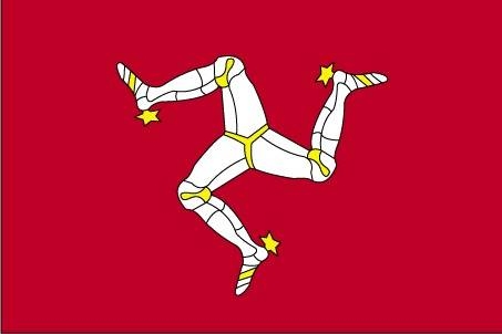
red with the Three Legs of Man emblem (triskelion), in the center; the three legs are joined at the thigh and bent at the knee; in order to have the toes pointing clockwise on both sides of the flag, a two-sided emblem is used; the flag is based on the coat of arms of the last recognized Norse King of Mann, MAGNUS III (r. 1252-65); the triskelion has its roots in an early Celtic sun symbol
National symbol(s)
triskelion (a motif of three legs); national colors: red, white
National anthem
name: "Arrane Ashoonagh dy Vannin" (O Land of Our Birth)
lyrics/music: William Henry GILL [English], John J. KNEEN [Manx]/traditional
note: adopted 2003, in use since 1907; serves as a local anthem; as a British Crown dependency, "God Save the King" is official (see United Kingdom) and is played when the sovereign, members of the royal family, or the lieutenant governor are present
Economy
Economic overview
Financial services, manufacturing, and tourism are key sectors of the economy. The government offers low taxes and other incentives to high-technology companies and financial institutions to locate on the island; this has paid off in expanding employment opportunities in high-income industries. As a result, agriculture and fishing, once the mainstays of the economy, have declined in their contributions to GDP. The Isle of Man also attracts online gambling sites and the film industry. Online gambling sites provided about 10% of the islands income in 2014. The Isle of Man currently enjoys free access to EU markets and trade is mostly with the UK. The Isle of Man’s trade relationship with the EU derives from the United Kingdom’s EU membership and will need to be renegotiated in light of the United Kingdom’s decision to withdraw from the bloc. A transition period is expected to allow the free movement of goods and agricultural products to the EU until the end of 2020 or until a new settlement is negotiated.
Real GDP (purchasing power parity)
$6.792 billion (2015 est.)
$7.428 billion (2014 est.)
$6.298 billion (2013 est.)
note: data are in 2014 US dollars
Real GDP growth rate
-8.6% (2015 est.)
17.9% (2014 est.)
2.1% (2010 est.)
Real GDP per capita
$84,600 (2014 est.)
$86,200 (2013 est.)
$73,700 (2012 est.)
GDP (official exchange rate)
$6.792 billion (2015 est.)
Credit ratings
Moody's rating: Aa3 (2020)
Standard & Poors rating: N/A
note: The year refers to the year in which the current credit rating was first obtained.
GDP - composition, by sector of origin
agriculture: 1% (FY12/13 est.)
industry: 13% (FY12/13 est.)
services: 86% (FY12/13 est.)
Agricultural products
cereals, vegetables; cattle, sheep, pigs, poultry
Industries
financial services, light manufacturing, tourism
Labor force - by occupation
manufacturing: 5% (2006 est.)
construction: 8% (2006 est.)
tourism: 1% (2006 est.)
transport and communications: 9% (2006 est.)
agriculture, forestry, and fishing: 2% (2006 est.)
gas, electricity, and water: 1% (2006 est.)
wholesale and retail distribution: 11% (2006 est.)
professional and scientific services: 20% (2006 est.)
public administration: 7% (2006 est.)
banking and finance: 23% (2006 est.)
entertainment and catering: 5% (2006 est.)
miscellaneous services: 8% (2006 est.)
Youth unemployment rate (ages 15-24)
total: 10.1%
male: 11.8%
female: 8.2% (2011 est.)
Household income or consumption by percentage share
lowest 10%: NA
highest 10%: NA
Budget
revenues: 965 million (FY05/06 est.)
expenditures: 943 million (FY05/06 est.)
Fiscal year
1 April - 31 March
Exports
NA
Exports - commodities
tweeds, herring, processed shellfish, beef, lamb
Imports
NA
Imports - commodities
timber, fertilizers, fish
Exchange rates
Manx pounds (IMP) per US dollar -
0.7836 (2017 est.)
0.738 (2016 est.)
0.738 (2015)
0.6542 (2014)
0.6472 (2013 est.)
Energy
Electricity access
electrification - total population: 100% (2020)
Communications
Telecommunication systems
general assessment: the Isle of Man has an extensive communications infrastructure consisting of telephone cables, submarine cables, and an array of television and mobile phone transmitters and towers (2022)
domestic: landline, telefax, mobile cellular telephone system
international: country code - 44; fiber-optic cable, microwave radio relay, satellite earth station, submarine cable
note: the COVID-19 pandemic continues to have a significant impact on production and supply chains globally; since 2020, some aspects of the telecom sector have experienced a downturn, particularly in mobile device production; progress toward 5G implementation has resumed, as well as upgrades to infrastructure; consumer spending on telecom services has increased due to the surge in demand for capacity and bandwidth; the crucial nature of telecom services as a tool for work and school from home is still evident, and the spike in this area has seen growth opportunities for development of new tools and increased services
Broadcast media
national public radio broadcasts over 3 FM stations and 1 AM station; 2 commercial broadcasters operating with 1 having multiple FM stations; receives radio and TV services via relays from British TV and radio broadcasters
Transportation
Airports - with paved runways
total: 1
1,524 to 2,437 m: 1 (2021)
Railways
total: 63 km (2008)
narrow gauge: 6 km (2008) 1.076-m gauge (6 km electrified)
57 0.914-mm gauge (29 km electrified) note: primarily summer tourist attractions
Ports and terminals
major seaport(s): Douglas, Ramsey
Military and Security
Military - note
defense is the responsibility of the UK
Transnational Issues
Disputes - international
none identified
