Saint Pierre and Miquelon
Introduction
Background
First settled by the French in the early 17th century, the islands represent the sole remaining vestige of France's once vast North American possessions. They attained the status of an overseas collectivity in 2003.
Visit the Definitions and Notes page to view a description of each topic.
Geography
Location
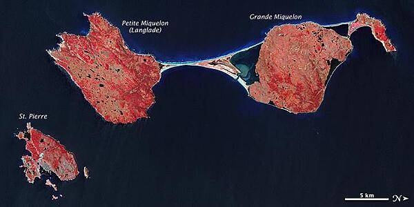
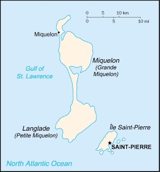
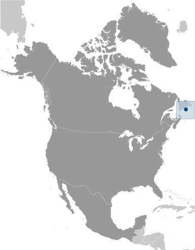
Northern North America, islands in the North Atlantic Ocean, south of Newfoundland (Canada)
Geographic coordinates
46 50 N, 56 20 W
Map references
North America
Area
total: 242 sq km
land: 242 sq km
water: 0 sq km
note: includes eight small islands in the Saint Pierre and the Miquelon groups
Area - comparative
one and half times the size of Washington, DC
Land boundaries
total: 0 km
Coastline
120 km
Maritime claims
territorial sea: 12 nm
exclusive economic zone: 200 nm
Climate
cold and wet, with considerable mist and fog; spring and autumn are often windy
Terrain
mostly barren rock
Elevation
highest point: Morne de la Grande Montagne 240 m
lowest point: Atlantic Ocean 0 m
Natural resources
fish, deepwater ports
Land use
agricultural land: 8.7% (2018 est.)
arable land: 8.7% (2018 est.)
permanent crops: 0% (2018 est.)
permanent pasture: 0% (2018 est.)
forest: 12.5% (2018 est.)
other: 78.8% (2018 est.)
Irrigated land
0 sq km (2012)
Population distribution
most of the population is found on Saint Pierre Island; a small settlement is located on the north end of Miquelon Island
Natural hazards
persistent fog throughout the year can be a maritime hazard
Geography - note
vegetation scanty; the islands are actually part of the northern Appalachians along with Newfoundland
People and Society
Nationality
noun: Frenchman(men), Frenchwoman(women)
adjective: French
Ethnic groups
Basques and Bretons (French fishermen)
Languages
French (official)
major-language sample(s):
The World Factbook, une source indispensable d'informations de base. (French)
The World Factbook, the indispensable source for basic information.
Religions
Roman Catholic 99%, other 1%
Age structure
0-14 years: 14.31% (male 395/female 370)
15-24 years: 8.83% (male 245/female 227)
25-54 years: 40% (male 1,039/female 1,100)
55-64 years: 14.49% (male 400/female 375)
65 years and over: 22.37% (male 513/female 683) (2020 est.)
Dependency ratios
total dependency ratio: NA
youth dependency ratio: NA
elderly dependency ratio: NA
potential support ratio: NA
Median age
total: 48.5 years
male: 47.9 years
female: 49 years (2020 est.)
Population distribution
most of the population is found on Saint Pierre Island; a small settlement is located on the north end of Miquelon Island
Urbanization
urban population: 90% of total population (2021)
rate of urbanization: 0.75% annual rate of change (2020-25 est.)
Major urban areas - population
6,000 SAINT-PIERRE (capital) (2018)
Sex ratio
at birth: 1.06 male(s)/female
0-14 years: 1.07 male(s)/female
15-24 years: 1.08 male(s)/female
25-54 years: 0.94 male(s)/female
55-64 years: 1.07 male(s)/female
65 years and over: 0.75 male(s)/female
total population: 0.94 male(s)/female (2020 est.)
Infant mortality rate
total: 8.35 deaths/1,000 live births
male: 10.37 deaths/1,000 live births
female: 6.23 deaths/1,000 live births (2021 est.)
Life expectancy at birth
total population: 81.2 years
male: 78.83 years
female: 83.7 years (2021 est.)
Drinking water source
improved: total: 91.4% of population
unimproved: total: 8.6% of population (2017 est.)
Environment
Environment - current issues
overfishing; recent test drilling for oil in waters around Saint Pierre and Miquelon may bring future development that would impact the environment
Climate
cold and wet, with considerable mist and fog; spring and autumn are often windy
Land use
agricultural land: 8.7% (2018 est.)
arable land: 8.7% (2018 est.)
permanent crops: 0% (2018 est.)
permanent pasture: 0% (2018 est.)
forest: 12.5% (2018 est.)
other: 78.8% (2018 est.)
Urbanization
urban population: 90% of total population (2021)
rate of urbanization: 0.75% annual rate of change (2020-25 est.)
Government
Country name
conventional long form: Territorial Collectivity of Saint Pierre and Miquelon
conventional short form: Saint Pierre and Miquelon
local long form: Departement de Saint-Pierre et Miquelon
local short form: Saint-Pierre et Miquelon
etymology: Saint-Pierre is named after Saint PETER, the patron saint of fishermen; Miquelon may be a corruption of the Basque name Mikelon
Government type
parliamentary democracy (Territorial Council); overseas collectivity of France
Dependency status
overseas collectivity of France
Capital
name: Saint-Pierre
geographic coordinates: 46 46 N, 56 11 W
time difference: UTC-3 (2 hours ahead of Washington, DC, during Standard Time)
daylight saving time: +1hr, begins second Sunday in March; ends first Sunday in November
etymology: named after Saint Peter, the patron saint of fisherman
Administrative divisions
none (territorial overseas collectivity of France); note - there are no first-order administrative divisions as defined by the US Government, but there are 2 communes at the second order - Saint Pierre, Miquelon
Independence
none (overseas collectivity collectivity of France; has been under French control since 1763)
National holiday
Fete de la Federation, 14 July (1790)
Constitution
history: 4 October 1958 (French Constitution)
amendments: amendment procedures of France's constitution apply
Legal system
French civil law
Citizenship
see France
Suffrage
18 years of age; universal
Executive branch
chief of state: President Emmanuel MACRON (since 14 May 2017); represented by Prefect Christian POUGET (since 6 January 2021)
head of government: President of Territorial Council Bernard BRIAND (since 13 October 2020)
cabinet: Le Cabinet du Prefet
elections/appointments: French president directly elected by absolute majority popular vote in 2 rounds if needed for a 5-year term (eligible for a second term); election last held on 23 April and 6 May 2017 (next to be held in 2022); prefect appointed by French president on the advice of French Ministry of Interior
Legislative branch
description: unicameral Territorial Council or Conseil Territorial (19 seats - Saint Pierre 15, Miquelon 4; members directly elected in single-seat constituencies by absolute majority vote in 2 rounds if needed to serve 6-year terms);
Saint Pierre and Miquelon indirectly elects 1 senator to the French Senate by an electoral college to serve a 6-year term and directly elects 1 deputy to the French National Assembly by absolute majority vote to serve a 5-year term
elections: Territorial Council - last held on 19 March 2017 (next to be held in March 2023)
French Senate - last held on 24 September 2017 (next to be held no later than September 2023)
French National Assembly - last held on 11 and 18 June 2017 (next to be held by June 2022)
election results: Territorial Council - percent of vote by party - AD 70.2%, Cap sur l'Avenir 29.8%; seats by party - AD 17, Cap sur l'Avenir 2; composition - men 10, women 9, percent of women 47.4%
French Senate - percent of vote by party - NA; seats by party - PS 1 (affiliated with UMP)
French National Assembly - percent of vote by party - NA; seats by party - Ensemble pour l'Avenir 1 (affiliated with PRG); the Republicans (LR) 1
Judicial branch
highest courts: Superior Tribunal of Appeals or Tribunal Superieur d'Appel (composition NA)
judge selection and term of office: judge selection and tenure NA
subordinate courts: NA
Political parties and leaders
Archipelago Tomorrow or AD (affiliated with UMP)
Cap sur l'Avenir [Annick GIRARDIN] (affiliated with Left Radical Party)
Togerther for the Future (Ensemble pour l'Avenir) (affiliated with PRG) SPM ensemble
International organization participation
UPU, WFTU (NGOs)
Diplomatic representation in the US
none (territorial overseas collectivity of France)
Diplomatic representation from the US
embassy: none (territorial overseas collectivity of France)
Flag description
a yellow three-masted sailing ship facing the hoist side rides on a blue background with scattered, white, wavy lines under the ship; a continuous black-over-white wavy line divides the ship from the white wavy lines; on the hoist side, a vertical band is divided into three parts: the top part (called ikkurina) is red with a green diagonal cross extending to the corners overlaid by a white cross dividing the rectangle into four sections; the middle part has a white background with an ermine pattern; the third part has a red background with two stylized yellow lions outlined in black, one above the other; these three heraldic arms represent settlement by colonists from the Basque Country (top), Brittany, and Normandy; the blue on the main portion of the flag symbolizes the Atlantic Ocean and the stylized ship represents the Grande Hermine in which Jacques Cartier "discovered" the islands in 1536
note: the flag of France used for official occasions
National symbol(s)
16th-century sailing ship
Economy
Economic overview
The inhabitants have traditionally earned their livelihood by fishing and by servicing fishing fleets operating off the coast of Newfoundland. The economy has been declining, however, because of disputes with Canada over fishing quotas and a steady decline in the number of ships stopping at Saint Pierre. The services sector accounted for 86% of GDP in 2010, the last year data is available for. Government employment accounts for than 46% of the GDP, and 78% of the population is working age.
The government hopes an expansion of tourism will boost economic prospects. Fish farming, crab fishing, and agriculture are being developed to diversify the local economy. Recent test drilling for oil may pave the way for development of the energy sector. Trade is the second largest sector in terms of value added created, where it contributes significantly to economic activity. The extractive industries and energy sector is the third largest sector of activity in the archipelago, attributable in part to the construction of a new thermal power plant in 2015.
Real GDP (purchasing power parity)
$261.3 million (2015 est.)
$215.3 million (2006 est.)
note: supplemented by annual payments from France of about $60 million
GDP (official exchange rate)
$261.3 million (2015 est.)
GDP - composition, by sector of origin
agriculture: 2% (2006 est.)
industry: 15% (2006 est.)
services: 83% (2006 est.)
Agricultural products
vegetables; poultry, cattle, sheep, pigs; fish
Industries
fish processing and supply base for fishing fleets; tourism
Labor force - by occupation
agriculture: 18%
industry: 41%
services: 41% (1996 est.)
Household income or consumption by percentage share
lowest 10%: NA
highest 10%: NA
Budget
revenues: 70 million (1996 est.)
expenditures: 60 million (1996 est.)
Fiscal year
calendar year
Exports - partners
Canada 79%, France 8%, Belgium 6% (2019)
Exports - commodities
crustaceans, fish, medical instruments, electrical parts, pasta (2019)
Imports - partners
France 69%, Canada 22% (2019)
Imports - commodities
food preparation, packaged medicines, low-voltage protection equipment, cars, computers, iron structures (2019)
Exchange rates
euros (EUR) per US dollar -
0.885 (2017 est.)
0.903 (2016 est.)
0.9214 (2015 est.)
0.885 (2014 est.)
0.7634 (2013 est.)
Energy
Electricity - installed generating capacity
27,600 kW (2016 est.)
country comparison to the world: 201Electricity - from fossil fuels
96% of total installed capacity (2016 est.)
country comparison to the world: 42Electricity - from nuclear fuels
0% of total installed capacity (2017 est.)
country comparison to the world: 174Electricity - from hydroelectric plants
0% of total installed capacity (2017 est.)
country comparison to the world: 197Electricity - from other renewable sources
4% of total installed capacity (2017 est.)
country comparison to the world: 117Communications
Telephones - fixed lines
total subscriptions: 4,086
subscriptions per 100 inhabitants: 75.55 (2019 est.)
Telecommunication systems
general assessment: adequate (2019)
domestic: fixed-line teledensity 76 per 100 persons (2019)
international: country code - 508; landing point for the St Pierre and Miquelon Cable connecting Saint Pierre & Miquelon and Canada; radiotelephone communication with most countries in the world; satellite earth station - 1 in French domestic satellite system (2019)
note: the COVID-19 pandemic continues to have a significant impact on production and supply chains globally; since 2020, some aspects of the telecom sector have experienced downturn, particularly in mobile device production; many network operators delayed upgrades to infrastructure; progress towards 5G implementation was postponed or slowed in some countries; consumer spending on telecom services and devices was affected by large-scale job losses and the consequent restriction on disposable incomes; the crucial nature of telecom services as a tool for work and school from home became evident, and received some support from governments
Broadcast media
8 TV stations, all part of the French Overseas Network, and local cable provided by SPM Telecom; 3 of 4 radio stations on St. Pierre and on Miquelon are part of the French Overseas Network (2021)
Internet users
total: 4,600 (2020 est.)
percent of population: 79.5% (July 2016 est.)
Transportation
Airports - with paved runways
total: 2
1,524 to 2,437 m: 1
914 to 1,523 m: 1 (2019)
Roadways
total: 117 km (2009)
paved: 80 km (2009)
unpaved: 37 km (2009)
Ports and terminals
major seaport(s): Saint-Pierre
Military and Security
Military - note
defense is the responsibility of France


